Property Record
600 Orchard Ave, Avalon, PA 15202
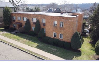

Property Detail
600 Orchard Ave
Pittsburgh, PA
R E BREED PLAN 1 TO 5 INCL LOT 130.12XAVG128.47 LOTS 1-5 = 110.39X100.00X139.31X104.10 R E BREED PLAN
0159-C-00099-0000-00
Allegheny
Apartment
Pennsylvania
B and X Area of moderate flood hazard, usually the area between the limits of the 100-year and 500-year floods.
99
2024
0.38 AC
2025
Avalon-Bellevue-Ben Avon
432400
Pittsburgh
NEARBY LISTINGS FOR SALE OR LEASE
DEMOGRAPHICS near 600 Orchard Ave
1 mile
3 mile
5 mile
2025 Total Population
10,484
69,901
176,037
2030 Population
10,175
68,563
173,896
Pop Growth 2025-2030
(2.95%)
(1.91%)
(1.22%)
Average Age
42
42
42
2025 Total Households
5,253
31,649
79,107
HH Growth 2025-2030
(3.05%)
(2.02%)
(1.29%)
Median Household Inc
$65,310
$69,590
$73,550
Avg Household Size
2.00
2.10
2.20
2025 Avg HH Vehicles
1.00
1.00
1.00
Median Home Value
$198,476
$211,599
$235,954
Median Year Built
1948
1951
1956
Nearby Places
Map Layers
Map Styles
 Street
 Aerial
Layers
 Traffic
 Biking
Places
Listings with unknown addresses are not visible on the map
- Restaurants
- Banks
- Shops
- Fitness
- Groceries
PUBLIC TRANSPORTATION
COMMUTER RAIL
Drive
Walk
Distance
14 min
6.6 mi
AIRPORT
Pittsburgh International
Drive
Walk
Distance
Pittsburgh International
25 min
12.3 mi
SALE & LEASE HISTORY
LISTING DATE
SALE/LEASE

Mar 22, 2022
For Sale
Nearby Properties
Address
Land Use
TOTAL SIZE
Lot Size
Zoning
Address
Land Use
TOTAL SIZE
Lot Size
Zoning
26.68 AC
Address
Land Use
TOTAL SIZE
Lot Size
Zoning
21.20 AC
Address
Land Use
TOTAL SIZE
Lot Size
Zoning
33.85 AC
Address
Land Use
TOTAL SIZE
Lot Size
Zoning
25.70 AC
Address
Land Use
TOTAL SIZE
Lot Size
Zoning
Address
Land Use
TOTAL SIZE
Lot Size
Zoning
45.85 AC
Address
Land Use
TOTAL SIZE
Lot Size
Zoning
25.09 AC
Address
Land Use
TOTAL SIZE
Lot Size
Zoning
88.84 AC
Address
Land Use
TOTAL SIZE
Lot Size
Zoning
Address
Land Use
TOTAL SIZE
Lot Size
Zoning
Address
Land Use
TOTAL SIZE
Lot Size
Zoning
6.52 AC
Address
Land Use
TOTAL SIZE
Lot Size
Zoning
9.18 AC
Address
Land Use
TOTAL SIZE
Lot Size
Zoning
21.49 AC
Address
Land Use
TOTAL SIZE
Lot Size
Zoning
Address
Land Use
TOTAL SIZE
Lot Size
Zoning
Address
Land Use
TOTAL SIZE
Lot Size
Zoning
5.74 AC
Address
Land Use
TOTAL SIZE
Lot Size
Zoning
8.31 AC
Address
Land Use
TOTAL SIZE
Lot Size
Zoning
Address
Land Use
TOTAL SIZE
Lot Size
Zoning
44.02 AC
Address
Land Use
TOTAL SIZE
Lot Size
Zoning
Address
Land Use
TOTAL SIZE
Lot Size
Zoning
5.58 AC
Address
Land Use
TOTAL SIZE
Lot Size
Zoning
Address
Land Use
TOTAL SIZE
Lot Size
Zoning
48.63 AC
Address
Land Use
TOTAL SIZE
Lot Size
Zoning
Address
Land Use
TOTAL SIZE
Lot Size
Zoning
2.20 AC
Address
Land Use
TOTAL SIZE
Lot Size
Zoning
8.69 AC
Address
Land Use
TOTAL SIZE
Lot Size
Zoning
Address
Land Use
TOTAL SIZE
Lot Size
Zoning
2,198 SF
4.05 AC
Address
Land Use
TOTAL SIZE
Lot Size
Zoning
45.06 AC
Address
Land Use
TOTAL SIZE
Lot Size
Zoning
4.76 AC
The World's #1 Commercial Real Estate Marketplace
Connect with us
© 2026 CoStar Group
The information above has been obtained from sources believed reliable. While we do not doubt its accuracy we have not verified it and make no guarantee, warranty or representation about it. It is your responsibility to independently confirm its accuracy and completeness. Any projections, opinions, assumptions, or estimates used are for example only and do not represent the current or future performance of the property. The value of this transaction to you depends on tax and other factors which should be evaluated by your tax, financial, and legal advisors. You and your advisors should conduct a careful, independent investigation of the property to determine to your satisfaction the suitability of the property for your needs.