Property Record
600 Pine Ave, Goleta, CA 93117
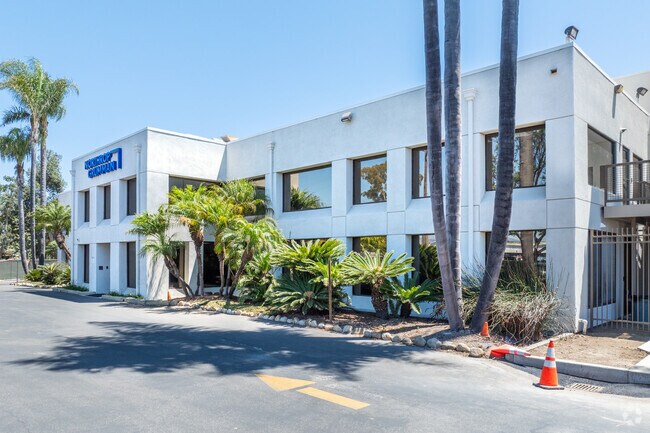

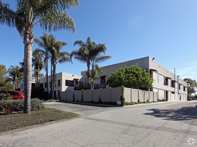
Property Detail
600 Pine Ave
Santa Maria-Santa Barbara, CA
RO GOLETA MAP 13A LOT 36
071-130-081
Santa Barbara
Lightindustrial
California
AO River or stream flood hazard areas, and areas with a 1% or greater chance of shallow flooding each year. These areas have a 26% chance of flooding over the life of a 30-year mortgage.
36
2024
4.73 AC
2025
Santa Barbara Airport
003001
Santa Barbara/Sta Maria/Goleta
53,294 SF
NEARBY LISTINGS FOR SALE OR LEASE
DEMOGRAPHICS near 600 Pine Ave
1 mile
3 mile
5 mile
2024 Total Population
10,492
59,729
93,591
2029 Population
10,780
59,679
93,534
Pop Growth 2024-2029
+ 2.74%
(0.08%)
(0.06%)
Average Age
43
37
39
2024 Total Households
4,109
20,023
33,196
HH Growth 2024-2029
+ 3.02%
+ 0.06%
+ 0.02%
Median Household Inc
$81,045
$95,148
$103,190
Avg Household Size
2.40
2.60
2.60
2024 Avg HH Vehicles
2.00
2.00
2.00
Median Home Value
$944,334
$1,091,173
$1,078,448
Median Year Built
1976
1973
1973
Nearby Places
Map Layers
Map Styles
 Street
 Aerial
Transit
 Traffic
 Biking
Places
Listings with unknown addresses are not visible on the map
- Restaurants
- Banks
- Shops
- Fitness
- Groceries
PUBLIC TRANSPORTATION
COMMUTER RAIL
Drive
Walk
Distance
7 min
2.1 mi
Drive
Walk
Distance
14 min
8.9 mi
AIRPORT
Santa Barbara Municipal
Drive
Walk
Distance
Santa Barbara Municipal
7 min
2.0 mi
Freight Ports
The Port of Hueneme
Drive
Walk
Distance
The Port of Hueneme
64 min
48.2 mi
SALE & LEASE HISTORY
LISTING DATE
SALE/LEASE

Sep 24, 2016
For Sale
Sep 23, 2016
For Sale
Jul 12, 2017
For Lease
Aug 17, 2017
For Sale
Nearby Properties
Address
Land Use
TOTAL SIZE
Lot Size
Zoning
Address
Land Use
TOTAL SIZE
Lot Size
Zoning
13,528 SF
9.35 AC
Address
Land Use
TOTAL SIZE
Lot Size
Zoning
20.78 AC
8R1
Address
Land Use
TOTAL SIZE
Lot Size
Zoning
2.50 AC
SRH20
Address
Land Use
TOTAL SIZE
Lot Size
Zoning
5.30 AC
Address
Land Use
TOTAL SIZE
Lot Size
Zoning
1.90 AC
Address
Land Use
TOTAL SIZE
Lot Size
Zoning
13.08 AC
Address
Land Use
TOTAL SIZE
Lot Size
Zoning
8.82 AC
Address
Land Use
TOTAL SIZE
Lot Size
Zoning
4.25 AC
Address
Land Use
TOTAL SIZE
Lot Size
Zoning
Address
Land Use
TOTAL SIZE
Lot Size
Zoning
2.42 AC
SRH20
Address
Land Use
TOTAL SIZE
Lot Size
Zoning
2.18 AC
Address
Land Use
TOTAL SIZE
Lot Size
Zoning
102,570 SF
14.03 AC
Address
Land Use
TOTAL SIZE
Lot Size
Zoning
3.05 AC
Address
Land Use
TOTAL SIZE
Lot Size
Zoning
37,584 SF
2 AC
SRH20
Address
Land Use
TOTAL SIZE
Lot Size
Zoning
3.81 AC
Address
Land Use
TOTAL SIZE
Lot Size
Zoning
85,052 SF
2.97 AC
SRH20
Address
Land Use
TOTAL SIZE
Lot Size
Zoning
7.18 AC
Address
Land Use
TOTAL SIZE
Lot Size
Zoning
7.99 AC
Address
Land Use
TOTAL SIZE
Lot Size
Zoning
0.87 AC
SRH20
Address
Land Use
TOTAL SIZE
Lot Size
Zoning
109,624 SF
9.11 AC
SC
Address
Land Use
TOTAL SIZE
Lot Size
Zoning
13.74 AC
Address
Land Use
TOTAL SIZE
Lot Size
Zoning
34,688 SF
2.17 AC
Address
Land Use
TOTAL SIZE
Lot Size
Zoning
6.90 AC
Address
Land Use
TOTAL SIZE
Lot Size
Zoning
0.38 AC
C2
Address
Land Use
TOTAL SIZE
Lot Size
Zoning
5.38 AC
Address
Land Use
TOTAL SIZE
Lot Size
Zoning
1.82 AC
Address
Land Use
TOTAL SIZE
Lot Size
Zoning
10.19 AC
Address
Land Use
TOTAL SIZE
Lot Size
Zoning
5.34 AC
Address
Land Use
TOTAL SIZE
Lot Size
Zoning
68,163 SF
4.04 AC
Address
Land Use
TOTAL SIZE
Lot Size
Zoning
18.65 AC
The World's #1 Commercial Real Estate Marketplace
Connect with us
© 2026 CoStar Group
The information above has been obtained from sources believed reliable. While we do not doubt its accuracy we have not verified it and make no guarantee, warranty or representation about it. It is your responsibility to independently confirm its accuracy and completeness. Any projections, opinions, assumptions, or estimates used are for example only and do not represent the current or future performance of the property. The value of this transaction to you depends on tax and other factors which should be evaluated by your tax, financial, and legal advisors. You and your advisors should conduct a careful, independent investigation of the property to determine to your satisfaction the suitability of the property for your needs.