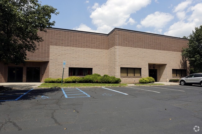
Property Record
600 Ryerson Rd, Lincoln Park, NJ 07035


Current Lease Availabilities
NEARBY LISTINGS FOR SALE OR LEASE
Property Detail
600 Ryerson Rd
16-00022-0000-00339-7
Final Subdivision Map For Frassetto
Industrialgeneral
Morris
AE
New Jersey
34027C0191F
5
2024
9.64 AC
2025
Eastern Morris
040102
Northern New Jersey
101,685 SF
Newark, NJ
DEMOGRAPHICS near 600 Ryerson Rd
1 Mile
3 Mile
5 Mile
2024 Total Population
5,980
46,929
163,044
2029 Population
5,990
46,743
161,814
Pop Growth 2024-2029
+ 0.17%
(0.40%)
(0.75%)
Average Age
42
43
43
2024 Total Households
2,286
16,394
57,907
HH Growth 2024-2029
+ 0.09%
(0.52%)
(0.89%)
Median Household Inc
$96,702
$126,750
$122,659
Avg Household Size
2.60
2.80
2.70
2024 Avg HH Vehicles
2.00
2.00
2.00
Median Home Value
$384,120
$511,005
$529,283
Median Year Built
1968
1964
1965
Nearby Places
Map Layers
Map Styles
 Street
 Aerial
- Restaurants
- Banks
- Shops
- Fitness
- Groceries
PUBLIC TRANSPORTATION
COMMUTER RAIL
Lincoln Park (Montclair-Boonton Line - NJ Transit Commuter Rail (NJ Transit))
DRIVE
WALK
Distance
Lincoln Park (Montclair-Boonton Line - NJ Transit Commuter Rail (NJ Transit))
4 min
1.4 mi
Mountain View (Montclair-Boonton Line - NJ Transit Commuter Rail (NJ Transit))
DRIVE
WALK
Distance
Mountain View (Montclair-Boonton Line - NJ Transit Commuter Rail (NJ Transit))
4 min
1.4 mi
AIRPORT
Newark Liberty International
DRIVE
WALK
Distance
Newark Liberty International
29 min
24.0 mi
LaGuardia
DRIVE
WALK
Distance
LaGuardia
45 min
32.0 mi
Westchester County
DRIVE
WALK
Distance
Westchester County
66 min
47.8 mi
Freight Ports
Maher Terminal
DRIVE
WALK
Distance
Maher Terminal
36 min
23.9 mi
Nearby Properties
Address
Land Use
TOTAL SIZE
Lot Size
Zoning
Address
Land Use
TOTAL SIZE
Lot Size
Zoning
667,698 SF
38.15 AC
Address
Land Use
TOTAL SIZE
Lot Size
Zoning
21.99 AC
H
Address
Land Use
TOTAL SIZE
Lot Size
Zoning
49,701 SF
29.34 AC
GAR
Address
Land Use
TOTAL SIZE
Lot Size
Zoning
49.48 AC
Address
Land Use
TOTAL SIZE
Lot Size
Zoning
8,600 SF
27.27 AC
L3
Address
Land Use
TOTAL SIZE
Lot Size
Zoning
960 SF
22.84 AC
GWS
Address
Land Use
TOTAL SIZE
Lot Size
Zoning
67.49 AC
Address
Land Use
TOTAL SIZE
Lot Size
Zoning
243,660 SF
20.53 AC
Address
Land Use
TOTAL SIZE
Lot Size
Zoning
207,519 SF
32.39 AC
Address
Land Use
TOTAL SIZE
Lot Size
Zoning
5,880 SF
17.46 AC
I
Address
Land Use
TOTAL SIZE
Lot Size
Zoning
342,518 SF
31.80 AC
IP
Address
Land Use
TOTAL SIZE
Lot Size
Zoning
251,974 SF
27.96 AC
Address
Land Use
TOTAL SIZE
Lot Size
Zoning
Address
Land Use
TOTAL SIZE
Lot Size
Zoning
136,500 SF
12.65 AC
HD
Address
Land Use
TOTAL SIZE
Lot Size
Zoning
192,206 SF
7.73 AC
R-20
Address
Land Use
TOTAL SIZE
Lot Size
Zoning
41.71 AC
C-4
Address
Land Use
TOTAL SIZE
Lot Size
Zoning
439,114 SF
19.21 AC
Address
Land Use
TOTAL SIZE
Lot Size
Zoning
9,874 SF
9.20 AC
HD
Address
Land Use
TOTAL SIZE
Lot Size
Zoning
97,631 SF
10.01 AC
B-2
Address
Land Use
TOTAL SIZE
Lot Size
Zoning
Address
Land Use
TOTAL SIZE
Lot Size
Zoning
175,000 SF
12.54 AC
L-1
Address
Land Use
TOTAL SIZE
Lot Size
Zoning
6.48 AC
HD
Address
Land Use
TOTAL SIZE
Lot Size
Zoning
374,755 SF
24.88 AC
Address
Land Use
TOTAL SIZE
Lot Size
Zoning
148,000 SF
6.44 AC
Address
Land Use
TOTAL SIZE
Lot Size
Zoning
9,448 SF
13.53 AC
HD
Address
Land Use
TOTAL SIZE
Lot Size
Zoning
9.08 AC
H-C
Address
Land Use
TOTAL SIZE
Lot Size
Zoning
8,628 SF
9.95 AC
HD
Address
Land Use
TOTAL SIZE
Lot Size
Zoning
14.01 AC
Address
Land Use
TOTAL SIZE
Lot Size
Zoning
Address
Land Use
TOTAL SIZE
Lot Size
Zoning
9.28 AC
R-11
The World's #1 Commercial Real Estate Marketplace
Connect with us
© 2026 CoStar Group
The information above has been obtained from sources believed reliable. While we do not doubt its accuracy we have not verified it and make no guarantee, warranty or representation about it. It is your responsibility to independently confirm its accuracy and completeness. Any projections, opinions, assumptions, or estimates used are for example only and do not represent the current or future performance of the property. The value of this transaction to you depends on tax and other factors which should be evaluated by your tax, financial, and legal advisors. You and your advisors should conduct a careful, independent investigation of the property to determine to your satisfaction the suitability of the property for your needs.