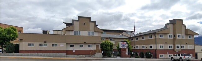
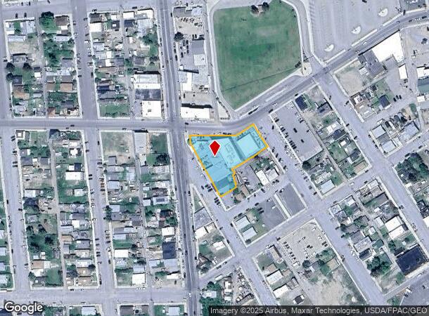
Property Record
600 S Main St, Butte, MT 59701
NEARBY LISTINGS FOR SALE OR LEASE
Property Detail
600 S Main St
Butte-Silver Bow, MT
Upton Add
01-1197-13-4-35-16-0000
UPTON ADD, S13, T03 N, R08 W, BLOCK 3, LOT 1 - 5, LT 6A OF PLAT 739-B, LT 10 & ADJ VAC ALLEY; NOYES & UPTON RR #2 - BLK 5 LTS
Officebuilding
Silver Bow
X
Montana
30093C0170E
1-5
2025
0.81 AC
2025
Uptown Butte
000102
Other Market Areas
21,205 SF
DEMOGRAPHICS near 600 S Main St
1 Mile
3 Mile
5 Mile
2024 Total Population
9,020
28,284
34,108
2029 Population
9,720
30,312
36,509
Pop Growth 2024-2029
+ 7.76%
+ 7.17%
+ 7.04%
Average Age
40
41
42
2024 Total Households
4,283
12,649
15,144
HH Growth 2024-2029
+ 7.96%
+ 7.28%
+ 7.15%
Median Household Inc
$30,388
$47,380
$49,770
Avg Household Size
1.90
2.10
2.10
2024 Avg HH Vehicles
1.00
2.00
2.00
Median Home Value
$139,710
$156,564
$169,582
Median Year Built
1945
1948
1952
Nearby Places
Map Layers
Map Styles
 Street
 Aerial
- Restaurants
- Banks
- Shops
- Fitness
- Groceries
Nearby Properties
Address
Land Use
TOTAL SIZE
Lot Size
Zoning
Address
Land Use
TOTAL SIZE
Lot Size
Zoning
174,891 SF
6.45 AC
3
Address
Land Use
TOTAL SIZE
Lot Size
Zoning
99,845 SF
1.55 AC
C3
Address
Land Use
TOTAL SIZE
Lot Size
Zoning
2,000 SF
9.12 AC
2
Address
Land Use
TOTAL SIZE
Lot Size
Zoning
7,740 SF
13.21 AC
R3
Address
Land Use
TOTAL SIZE
Lot Size
Zoning
74,010 SF
7.41 AC
R-4
Address
Land Use
TOTAL SIZE
Lot Size
Zoning
44,945 SF
3
Address
Land Use
TOTAL SIZE
Lot Size
Zoning
75,921 SF
5.27 AC
C-2
Address
Land Use
TOTAL SIZE
Lot Size
Zoning
53,459 SF
1.90 AC
C2
Address
Land Use
TOTAL SIZE
Lot Size
Zoning
54,557 SF
3.01 AC
R-1
Address
Land Use
TOTAL SIZE
Lot Size
Zoning
49,791 SF
1.81 AC
C-2
Address
Land Use
TOTAL SIZE
Lot Size
Zoning
47,740 SF
4.76 AC
R1
Address
Land Use
TOTAL SIZE
Lot Size
Zoning
91,860 SF
0.48 AC
C3
Address
Land Use
TOTAL SIZE
Lot Size
Zoning
86,040 SF
7.89 AC
1
Address
Land Use
TOTAL SIZE
Lot Size
Zoning
40,875 SF
10.14 AC
M-2L
Address
Land Use
TOTAL SIZE
Lot Size
Zoning
83,246 SF
59.93 AC
C2
Address
Land Use
TOTAL SIZE
Lot Size
Zoning
35,008 SF
3.21 AC
C2
Address
Land Use
TOTAL SIZE
Lot Size
Zoning
5,706 SF
119 AC
R2
Address
Land Use
TOTAL SIZE
Lot Size
Zoning
272,408 SF
22.65 AC
6
Address
Land Use
TOTAL SIZE
Lot Size
Zoning
34,039 SF
0.21 AC
C3
Address
Land Use
TOTAL SIZE
Lot Size
Zoning
53,095 SF
2.86 AC
C-2
Address
Land Use
TOTAL SIZE
Lot Size
Zoning
40,212 SF
1.77 AC
C-2
Address
Land Use
TOTAL SIZE
Lot Size
Zoning
60,468 SF
4.89 AC
1
Address
Land Use
TOTAL SIZE
Lot Size
Zoning
18,066 SF
3.51 AC
R1
Address
Land Use
TOTAL SIZE
Lot Size
Zoning
44,416 SF
6.58 AC
C-2L
Address
Land Use
TOTAL SIZE
Lot Size
Zoning
60,000 SF
7.50 AC
7
Address
Land Use
TOTAL SIZE
Lot Size
Zoning
83,012 SF
3.90 AC
C-2
Address
Land Use
TOTAL SIZE
Lot Size
Zoning
36,762 SF
9 AC
R1
Address
Land Use
TOTAL SIZE
Lot Size
Zoning
11,008 SF
3.38 AC
1
Address
Land Use
TOTAL SIZE
Lot Size
Zoning
4,258 SF
2.90 AC
R3
The World's #1 Commercial Real Estate Marketplace
Connect with us
© 2025 CoStar Group
The information above has been obtained from sources believed reliable. While we do not doubt its accuracy we have not verified it and make no guarantee, warranty or representation about it. It is your responsibility to independently confirm its accuracy and completeness. Any projections, opinions, assumptions, or estimates used are for example only and do not represent the current or future performance of the property. The value of this transaction to you depends on tax and other factors which should be evaluated by your tax, financial, and legal advisors. You and your advisors should conduct a careful, independent investigation of the property to determine to your satisfaction the suitability of the property for your needs.