Property Record
600 S Pine Island Rd, Plantation, FL 33324
Current Lease Availabilities
NEARBY LISTINGS FOR SALE OR LEASE
Property Detail
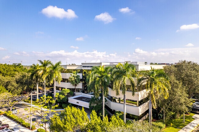
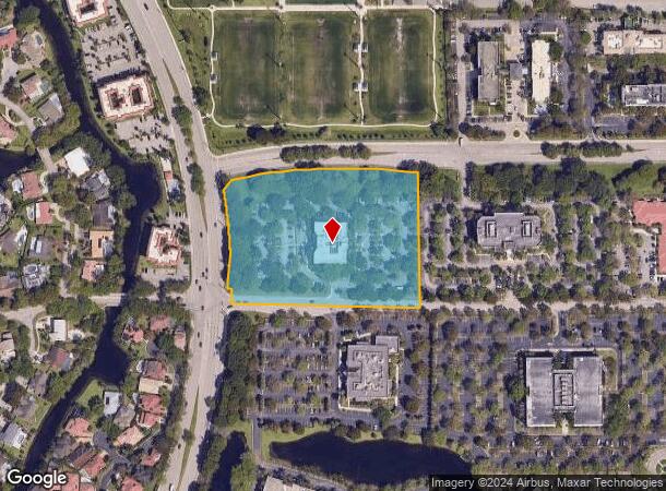
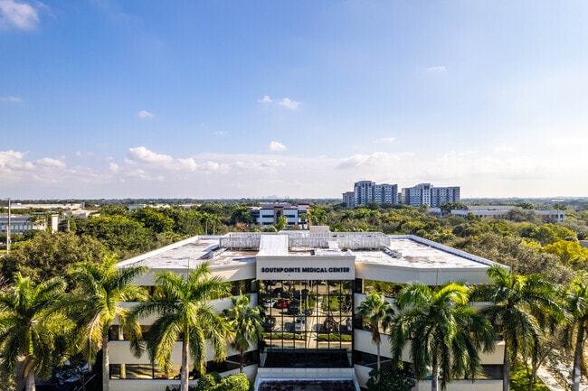
600 S Pine Island Rd
Fort Lauderdale-Pompano Beach-Sunrise, FL
Jacaranda Parcel 817
50-41-09-27-0051
JACARANDA PARCEL 817 143-1 B POR OF PAR 5 DESC AS:COMM NE COR SAID PAR 5,W 161.12 TO POB, W 28.88,NW 100.72, W 174.40,WLY 242.22,SW 59.85,SW 41.71,SLY 200 SW 100.42, SLY 15.63, E 12, SLY 49.75, E 607.33, N 438.07 TO POB AKA:PARCEL 5A
Officebuilding
Broward
X
Florida
12011C0535J
5
2024
6.10 AC
2025
Plantation
061004
South Florida
51,348 SF
DEMOGRAPHICS near 600 S Pine Island Rd
1 Mile
3 Mile
5 Mile
2024 Total Population
13,780
119,626
377,696
2029 Population
14,219
118,462
376,043
Pop Growth 2024-2029
+ 3.19%
(0.97%)
(0.44%)
Average Age
40
41
40
2024 Total Households
6,045
46,792
140,590
HH Growth 2024-2029
+ 2.86%
(1.35%)
(0.69%)
Median Household Inc
$81,002
$80,518
$62,743
Avg Household Size
2.20
2.40
2.60
2024 Avg HH Vehicles
2.00
2.00
2.00
Median Home Value
$429,900
$367,004
$315,412
Median Year Built
1987
1982
1979
Nearby Places
Map Layers
Map Styles
 Street
 Aerial
- Restaurants
- Banks
- Shops
- Fitness
- Groceries
PUBLIC TRANSPORTATION
COMMUTER RAIL
Fort Lauderdale (Tri-County Commuter - South Florida Regional Transportation Authority (Tri-Rail))
DRIVE
WALK
Distance
Fort Lauderdale (Tri-County Commuter - South Florida Regional Transportation Authority (Tri-Rail))
15 min
6.8 mi
DRIVE
WALK
Distance
17 min
8.1 mi
AIRPORT
Fort Lauderdale/Hollywood International
DRIVE
WALK
Distance
Fort Lauderdale/Hollywood International
17 min
9.1 mi
Miami International
DRIVE
WALK
Distance
Miami International
45 min
32.9 mi
Freight Ports
Port Everglades
DRIVE
WALK
Distance
Port Everglades
17 min
11.1 mi
Nearby Properties
Address
Land Use
TOTAL SIZE
Lot Size
Zoning
Address
Land Use
TOTAL SIZE
Lot Size
Zoning
4,069,966 SF
161.58 AC
RAC-AV
Address
Land Use
TOTAL SIZE
Lot Size
Zoning
589,748 SF
27.34 AC
RAC-RTE
Address
Land Use
TOTAL SIZE
Lot Size
Zoning
663,255 SF
3.15 AC
RAC-CC
Address
Land Use
TOTAL SIZE
Lot Size
Zoning
632,250 SF
34.15 AC
PRD-11.6Q
Address
Land Use
TOTAL SIZE
Lot Size
Zoning
1,357,572 SF
126.23 AC
RAC-ED
Address
Land Use
TOTAL SIZE
Lot Size
Zoning
458,854 SF
30.97 AC
PRD-15Q **
Address
Land Use
TOTAL SIZE
Lot Size
Zoning
627,368 SF
4.33 AC
PRD-21Q
Address
Land Use
TOTAL SIZE
Lot Size
Zoning
507,890 SF
39.49 AC
M-PM
Address
Land Use
TOTAL SIZE
Lot Size
Zoning
475,897 SF
14.91 AC
RAC-RTE
Address
Land Use
TOTAL SIZE
Lot Size
Zoning
413,123 SF
63.50 AC
B-3
Address
Land Use
TOTAL SIZE
Lot Size
Zoning
438,123 SF
47.44 AC
RM-22
Address
Land Use
TOTAL SIZE
Lot Size
Zoning
409,340 SF
15.49 AC
RAC-RTE
Address
Land Use
TOTAL SIZE
Lot Size
Zoning
613,363 SF
6.24 AC
B-7Q
Address
Land Use
TOTAL SIZE
Lot Size
Zoning
517,961 SF
3.92 AC
M-PM
Address
Land Use
TOTAL SIZE
Lot Size
Zoning
337,553 SF
39.13 AC
RM-10
Address
Land Use
TOTAL SIZE
Lot Size
Zoning
497,004 SF
4.46 AC
M-PM
Address
Land Use
TOTAL SIZE
Lot Size
Zoning
456,384 SF
81.33 AC
RAC-ED
Address
Land Use
TOTAL SIZE
Lot Size
Zoning
524,015 SF
6.43 AC
B-7Q
Address
Land Use
TOTAL SIZE
Lot Size
Zoning
471,109 SF
5.57 AC
M-PM
Address
Land Use
TOTAL SIZE
Lot Size
Zoning
527,086 SF
2.34 AC
M-PM
Address
Land Use
TOTAL SIZE
Lot Size
Zoning
334,723 SF
7.47 AC
RAC-AV
Address
Land Use
TOTAL SIZE
Lot Size
Zoning
356,053 SF
8.12 AC
RAC-RTE
Address
Land Use
TOTAL SIZE
Lot Size
Zoning
320,919 SF
27.70 AC
M-PM
Address
Land Use
TOTAL SIZE
Lot Size
Zoning
439,908 SF
13.54 AC
OP-P
Address
Land Use
TOTAL SIZE
Lot Size
Zoning
505,730 SF
18.07 AC
RAC-AV
Address
Land Use
TOTAL SIZE
Lot Size
Zoning
256,568 SF
22.61 AC
PRD-12.15Q
Address
Land Use
TOTAL SIZE
Lot Size
Zoning
312,067 SF
20.94 AC
PRD-15Q
Address
Land Use
TOTAL SIZE
Lot Size
Zoning
321,240 SF
2.16 AC
M-PM
Address
Land Use
TOTAL SIZE
Lot Size
Zoning
277,664 SF
21.35 AC
PRD-12.15Q
Address
Land Use
TOTAL SIZE
Lot Size
Zoning
445,798 SF
11.80 AC
OP-P
The World's #1 Commercial Real Estate Marketplace
Connect with us
© 2026 CoStar Group
The information above has been obtained from sources believed reliable. While we do not doubt its accuracy we have not verified it and make no guarantee, warranty or representation about it. It is your responsibility to independently confirm its accuracy and completeness. Any projections, opinions, assumptions, or estimates used are for example only and do not represent the current or future performance of the property. The value of this transaction to you depends on tax and other factors which should be evaluated by your tax, financial, and legal advisors. You and your advisors should conduct a careful, independent investigation of the property to determine to your satisfaction the suitability of the property for your needs.