Property Record
600 Santee Rd, Durham, NC 27704
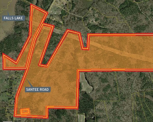

Property Detail
600 Santee Rd
193815
PROP-DURHAM COUNTY PL:000191-000340
Agriculturalland
DURHAM
RR
North Carolina
AE The base floodplain where base flood elevations are provided. AE Zones are now used on new format FIRMs instead of A1-A30 Zones.
260.12 AC
0
North Durham
2025
Raleigh/Durham
001801
Durham-Chapel Hill, NC
NEARBY LISTINGS FOR SALE OR LEASE
DEMOGRAPHICS near 600 Santee Rd
1 mile
3 mile
5 mile
2025 Total Population
90
10,797
47,354
2030 Population
100
11,504
50,474
Pop Growth 2025-2030
+ 11.11%
+ 6.55%
+ 6.59%
Average Age
46
41
41
2025 Total Households
36
4,032
17,686
HH Growth 2025-2030
+ 11.11%
+ 6.89%
+ 6.89%
Median Household Inc
$140,277
$111,210
$108,955
Avg Household Size
2.40
2.60
2.60
2025 Avg HH Vehicles
3.00
2.00
2.00
Median Home Value
$612,500
$370,503
$400,896
Median Year Built
2003
2001
2003
Nearby Places
Map Layers
Map Styles
 Street
 Aerial
Transit
 Traffic
 Biking
Places
Listings with unknown addresses are not visible on the map
- Restaurants
- Banks
- Shops
- Fitness
- Groceries
PUBLIC TRANSPORTATION
COMMUTER RAIL
Durham Amtrak Station (Carolinian - Amtrak, Piedmont - Amtrak)
Drive
Walk
Distance
Durham Amtrak Station (Carolinian - Amtrak, Piedmont - Amtrak)
22 min
9.6 mi
AIRPORT
Raleigh-Durham International
Drive
Walk
Distance
Raleigh-Durham International
25 min
12.6 mi
Freight Ports
Virginia Port Authority - Richmond
Drive
Walk
Distance
Virginia Port Authority - Richmond
176 min
147.9 mi
Nearby Properties
Address
Land Use
TOTAL SIZE
Lot Size
Zoning
Address
Land Use
TOTAL SIZE
Lot Size
Zoning
61,242 SF
8.59 AC
CC(D)
Address
Land Use
TOTAL SIZE
Lot Size
Zoning
131,114 SF
48.95 AC
RR
Address
Land Use
TOTAL SIZE
Lot Size
Zoning
181.12 AC
PDR 2.883
Address
Land Use
TOTAL SIZE
Lot Size
Zoning
319.81 AC
RR
Address
Land Use
TOTAL SIZE
Lot Size
Zoning
13,824 SF
3.55 AC
SPLIT
Address
Land Use
TOTAL SIZE
Lot Size
Zoning
12,040 SF
1.79 AC
CN
Address
Land Use
TOTAL SIZE
Lot Size
Zoning
17,105 SF
36.53 AC
RR
Address
Land Use
TOTAL SIZE
Lot Size
Zoning
39.84 AC
PDR 3.551
Address
Land Use
TOTAL SIZE
Lot Size
Zoning
7,764 SF
4.62 AC
CC
Address
Land Use
TOTAL SIZE
Lot Size
Zoning
170.90 AC
RR
Address
Land Use
TOTAL SIZE
Lot Size
Zoning
175.69 AC
RR
Address
Land Use
TOTAL SIZE
Lot Size
Zoning
63.10 AC
RR
Address
Land Use
TOTAL SIZE
Lot Size
Zoning
5,200 SF
50.75 AC
RR
Address
Land Use
TOTAL SIZE
Lot Size
Zoning
116.70 AC
RR
Address
Land Use
TOTAL SIZE
Lot Size
Zoning
99.33 AC
RR
Address
Land Use
TOTAL SIZE
Lot Size
Zoning
3,134 SF
90.48 AC
RR
Address
Land Use
TOTAL SIZE
Lot Size
Zoning
4,273 SF
64.26 AC
RR
Address
Land Use
TOTAL SIZE
Lot Size
Zoning
3,288 SF
92.02 AC
RR
Address
Land Use
TOTAL SIZE
Lot Size
Zoning
134.90 AC
RR
Address
Land Use
TOTAL SIZE
Lot Size
Zoning
13,988 SF
156.30 AC
RR
Address
Land Use
TOTAL SIZE
Lot Size
Zoning
11,514 SF
2.23 AC
CC(D)
Address
Land Use
TOTAL SIZE
Lot Size
Zoning
2,458 SF
91.38 AC
RR
Address
Land Use
TOTAL SIZE
Lot Size
Zoning
6,841 SF
20.10 AC
RR
Address
Land Use
TOTAL SIZE
Lot Size
Zoning
147.70 AC
RR
Address
Land Use
TOTAL SIZE
Lot Size
Zoning
9,180 SF
0.94 AC
CC(D)
Address
Land Use
TOTAL SIZE
Lot Size
Zoning
24.73 AC
RR
Address
Land Use
TOTAL SIZE
Lot Size
Zoning
4,237 SF
1.38 AC
CC(D)
Address
Land Use
TOTAL SIZE
Lot Size
Zoning
3,631 SF
44.20 AC
RR,RS-20
Address
Land Use
TOTAL SIZE
Lot Size
Zoning
4,776 SF
53.30 AC
RR
The World's #1 Commercial Real Estate Marketplace
Connect with us
© 2026 CoStar Group
The information above has been obtained from sources believed reliable. While we do not doubt its accuracy we have not verified it and make no guarantee, warranty or representation about it. It is your responsibility to independently confirm its accuracy and completeness. Any projections, opinions, assumptions, or estimates used are for example only and do not represent the current or future performance of the property. The value of this transaction to you depends on tax and other factors which should be evaluated by your tax, financial, and legal advisors. You and your advisors should conduct a careful, independent investigation of the property to determine to your satisfaction the suitability of the property for your needs.