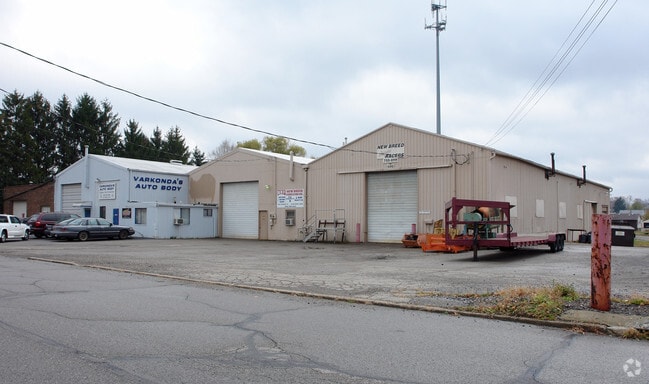
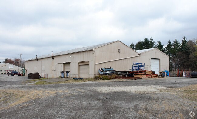
Property Record
600 Spring St, Struthers, OH 44471
Property Detail
600 Spring St
Youngstown-Warren, OH
LOT 6840 131.86 X 315.00 IRR REPLAT OF STRUTHERS CITY LOT NO 6840
38-016-0-342.02-0
Mahoning
Commercialnec
Ohio
2025
6840
2025
1.11 AC
810700
Mahoning County
9,920 SF
Youngstown/Warren/Boardman
NEARBY LISTINGS FOR SALE OR LEASE
DEMOGRAPHICS near 600 Spring St
1 mile
3 mile
5 mile
2025 Total Population
11,358
59,726
113,083
2030 Population
11,284
59,627
112,962
Pop Growth 2025-2030
(0.65%)
(0.17%)
(0.11%)
Average Age
42
41
42
2025 Total Households
4,986
25,504
48,357
HH Growth 2025-2030
(0.70%)
(0.21%)
(0.15%)
Median Household Inc
$51,933
$48,876
$48,404
Avg Household Size
2.20
2.30
2.20
2025 Avg HH Vehicles
2.00
2.00
2.00
Median Home Value
$86,832
$109,371
$127,592
Median Year Built
1954
1954
1956
Nearby Places
Map Layers
Map Styles
 Street
 Aerial
Transit
 Traffic
 Biking
Places
Listings with unknown addresses are not visible on the map
- Restaurants
- Banks
- Shops
- Fitness
- Groceries
Nearby Properties
Address
Land Use
TOTAL SIZE
Lot Size
Zoning
Address
Land Use
TOTAL SIZE
Lot Size
Zoning
252,909 SF
22.37 AC
C
Address
Land Use
TOTAL SIZE
Lot Size
Zoning
Address
Land Use
TOTAL SIZE
Lot Size
Zoning
139,416 SF
9.06 AC
Address
Land Use
TOTAL SIZE
Lot Size
Zoning
0.53 AC
Address
Land Use
TOTAL SIZE
Lot Size
Zoning
15.60 AC
Address
Land Use
TOTAL SIZE
Lot Size
Zoning
140,889 SF
14.71 AC
C
Address
Land Use
TOTAL SIZE
Lot Size
Zoning
134,650 SF
16.10 AC
C
Address
Land Use
TOTAL SIZE
Lot Size
Zoning
121,281 SF
11.79 AC
Address
Land Use
TOTAL SIZE
Lot Size
Zoning
96,005 SF
3.89 AC
C
Address
Land Use
TOTAL SIZE
Lot Size
Zoning
108,150 SF
6.06 AC
C
Address
Land Use
TOTAL SIZE
Lot Size
Zoning
79,778 SF
5.85 AC
Address
Land Use
TOTAL SIZE
Lot Size
Zoning
53,530 SF
5.85 AC
Address
Land Use
TOTAL SIZE
Lot Size
Zoning
39,370 SF
10.58 AC
C
Address
Land Use
TOTAL SIZE
Lot Size
Zoning
259,148 SF
15 AC
Address
Land Use
TOTAL SIZE
Lot Size
Zoning
56,688 SF
10.33 AC
R1
Address
Land Use
TOTAL SIZE
Lot Size
Zoning
66,482 SF
10.80 AC
Address
Land Use
TOTAL SIZE
Lot Size
Zoning
141,528 SF
16.11 AC
C
Address
Land Use
TOTAL SIZE
Lot Size
Zoning
140,132 SF
8.91 AC
C
Address
Land Use
TOTAL SIZE
Lot Size
Zoning
123,138 SF
8.16 AC
C
Address
Land Use
TOTAL SIZE
Lot Size
Zoning
68,415 SF
11.60 AC
R1
Address
Land Use
TOTAL SIZE
Lot Size
Zoning
29,735 SF
8.65 AC
C
Address
Land Use
TOTAL SIZE
Lot Size
Zoning
69,600 SF
5.84 AC
C
Address
Land Use
TOTAL SIZE
Lot Size
Zoning
134,320 SF
3.36 AC
Address
Land Use
TOTAL SIZE
Lot Size
Zoning
77,880 SF
6.38 AC
Address
Land Use
TOTAL SIZE
Lot Size
Zoning
58,865 SF
4.80 AC
Address
Land Use
TOTAL SIZE
Lot Size
Zoning
67,143 SF
7.54 AC
C
Address
Land Use
TOTAL SIZE
Lot Size
Zoning
55,042 SF
5.72 AC
C
Address
Land Use
TOTAL SIZE
Lot Size
Zoning
74,523 SF
4.04 AC
Address
Land Use
TOTAL SIZE
Lot Size
Zoning
115,719 SF
8.70 AC
I
Address
Land Use
TOTAL SIZE
Lot Size
Zoning
164,368 SF
31.04 AC
The World's #1 Commercial Real Estate Marketplace
Connect with us
© 2026 CoStar Group
The information above has been obtained from sources believed reliable. While we do not doubt its accuracy we have not verified it and make no guarantee, warranty or representation about it. It is your responsibility to independently confirm its accuracy and completeness. Any projections, opinions, assumptions, or estimates used are for example only and do not represent the current or future performance of the property. The value of this transaction to you depends on tax and other factors which should be evaluated by your tax, financial, and legal advisors. You and your advisors should conduct a careful, independent investigation of the property to determine to your satisfaction the suitability of the property for your needs.