Property Record
600 State Road 13 N, Saint Johns, FL 32259


NEARBY LISTINGS FOR SALE OR LEASE
-
-
View all Saint Johns listings for sale on LoopNet.com
Property Detail
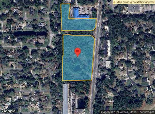
600 State Road 13 N
Jacksonville, FL
Fruit Cove Estates
005120-0000
3 ALL W1/2 LOT 1 LYING W OF RD 13 (EX PT N 500 FT & EX PT IN FRUIT COVE ESTATES SUB) OR221/420 & 4228/1308
Commercialacreage
St. Johns
X
Florida
12109C0132J
1
2023
7.70 AC
2025
St Johns County
020803
Jacksonville (Florida)
600 SF
DEMOGRAPHICS near 600 State Road 13 N
1 Mile
3 Mile
5 Mile
2024 Total Population
5,520
41,547
104,995
2029 Population
7,181
50,884
122,386
Pop Growth 2024-2029
+ 30.09%
+ 22.47%
+ 16.56%
Average Age
46
42
41
2024 Total Households
1,888
14,394
37,986
HH Growth 2024-2029
+ 29.71%
+ 21.32%
+ 15.01%
Median Household Inc
$122,868
$121,678
$104,514
Avg Household Size
2.60
2.80
2.70
2024 Avg HH Vehicles
2.00
2.00
2.00
Median Home Value
$374,999
$381,936
$348,752
Median Year Built
1989
1996
1994
Nearby Places
Map Layers
Map Styles
 Street
 Aerial
- Restaurants
- Banks
- Shops
- Fitness
- Groceries
PUBLIC TRANSPORTATION
AIRPORT
Jacksonville International
DRIVE
WALK
Distance
Jacksonville International
53 min
38.0 mi
Freight Ports
Jacksonville Port
DRIVE
WALK
Distance
Jacksonville Port
38 min
21.0 mi
Nearby Properties
Address
Land Use
TOTAL SIZE
Lot Size
Zoning
Address
Land Use
TOTAL SIZE
Lot Size
Zoning
193,858 SF
8.67 AC
PUD
Address
Land Use
TOTAL SIZE
Lot Size
Zoning
96,065 SF
4.11 AC
PUD
Address
Land Use
TOTAL SIZE
Lot Size
Zoning
321,392 SF
42.84 AC
PUD
Address
Land Use
TOTAL SIZE
Lot Size
Zoning
80,974 SF
4.94 AC
CCG-1
Address
Land Use
TOTAL SIZE
Lot Size
Zoning
65,155 SF
58.66 AC
OR
Address
Land Use
TOTAL SIZE
Lot Size
Zoning
66,280 SF
9.45 AC
PUD
Address
Land Use
TOTAL SIZE
Lot Size
Zoning
94,789 SF
30 AC
OR
Address
Land Use
TOTAL SIZE
Lot Size
Zoning
123,398 SF
25.30 AC
PUD
Address
Land Use
TOTAL SIZE
Lot Size
Zoning
50,800 SF
2.39 AC
PUD
Address
Land Use
TOTAL SIZE
Lot Size
Zoning
82,518 SF
10.27 AC
PSD
Address
Land Use
TOTAL SIZE
Lot Size
Zoning
95,870 SF
9.71 AC
OR
Address
Land Use
TOTAL SIZE
Lot Size
Zoning
45,676 SF
5.86 AC
PUD
Address
Land Use
TOTAL SIZE
Lot Size
Zoning
46,789 SF
5.86 AC
Address
Land Use
TOTAL SIZE
Lot Size
Zoning
101,150 SF
11.51 AC
PUD
Address
Land Use
TOTAL SIZE
Lot Size
Zoning
25,837 SF
5.05 AC
OR
Address
Land Use
TOTAL SIZE
Lot Size
Zoning
91,522 SF
9.84 AC
PUD
Address
Land Use
TOTAL SIZE
Lot Size
Zoning
81,119 SF
8.98 AC
PUD
Address
Land Use
TOTAL SIZE
Lot Size
Zoning
93,536 SF
3.85 AC
CCG-1
Address
Land Use
TOTAL SIZE
Lot Size
Zoning
75,805 SF
36.69 AC
PUD
Address
Land Use
TOTAL SIZE
Lot Size
Zoning
30,328 SF
2.97 AC
CG
Address
Land Use
TOTAL SIZE
Lot Size
Zoning
32,417 SF
3.48 AC
PUD
Address
Land Use
TOTAL SIZE
Lot Size
Zoning
18,774 SF
4.25 AC
PUD
Address
Land Use
TOTAL SIZE
Lot Size
Zoning
41,885 SF
2.38 AC
PUD
Address
Land Use
TOTAL SIZE
Lot Size
Zoning
25,792 SF
2.64 AC
PBF-1
Address
Land Use
TOTAL SIZE
Lot Size
Zoning
19,664 SF
0.40 AC
CCG-1
Address
Land Use
TOTAL SIZE
Lot Size
Zoning
4,720 SF
36.92 AC
PBF-1
Address
Land Use
TOTAL SIZE
Lot Size
Zoning
33,704 SF
3.72 AC
PUD
Address
Land Use
TOTAL SIZE
Lot Size
Zoning
10,427 SF
1.78 AC
Address
Land Use
TOTAL SIZE
Lot Size
Zoning
122,561 SF
48.29 AC
OR
Address
Land Use
TOTAL SIZE
Lot Size
Zoning
11,431 SF
3.77 AC
PUD
The World's #1 Commercial Real Estate Marketplace
Connect with us
© 2025 CoStar Group
The information above has been obtained from sources believed reliable. While we do not doubt its accuracy we have not verified it and make no guarantee, warranty or representation about it. It is your responsibility to independently confirm its accuracy and completeness. Any projections, opinions, assumptions, or estimates used are for example only and do not represent the current or future performance of the property. The value of this transaction to you depends on tax and other factors which should be evaluated by your tax, financial, and legal advisors. You and your advisors should conduct a careful, independent investigation of the property to determine to your satisfaction the suitability of the property for your needs.