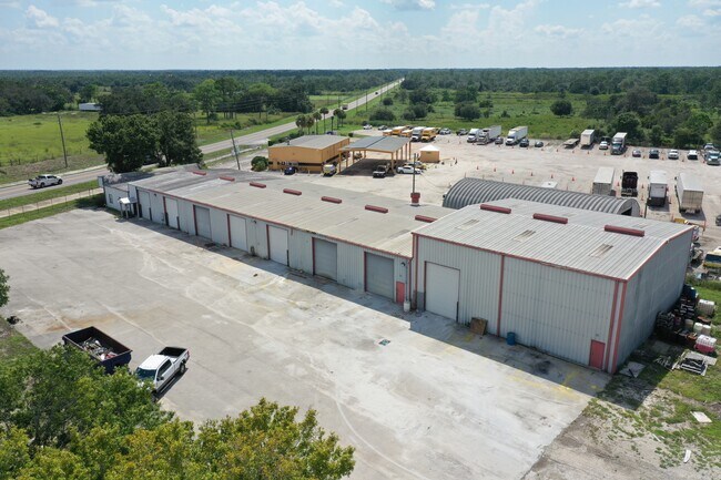
Property Record
600 State Road 66, Sebring, FL 33875

Property Detail
600 State Road 66
C-16-35-29-020-0000-0310
GEORGETOWN INDUSTRIAL PARK PB 13 PG 41 LOT 31
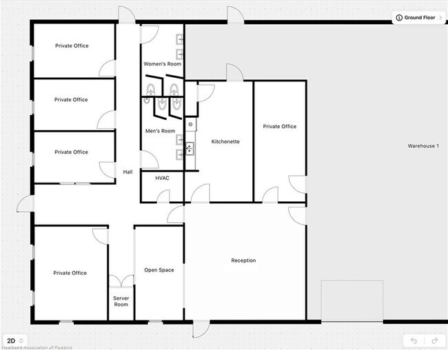
Warehouse
Highlands
I2
Florida
B and X Area of moderate flood hazard, usually the area between the limits of the 100-year and 500-year floods.
31
2024
1.41 AC
2025
Florida Central South Area
961303
Other Market Areas
15,900 SF
Sebring, FL
NEARBY LISTINGS FOR SALE OR LEASE
-
-
View all Sebring listings for lease on LoopNet.com
DEMOGRAPHICS near 600 State Road 66
1 mile
3 mile
5 mile
2025 Total Population
125
8,096
24,830
2030 Population
135
8,785
26,752
Pop Growth 2025-2030
+ 8.00%
+ 8.51%
+ 7.74%
Average Age
55
54
49
2025 Total Households
59
3,813
10,993
HH Growth 2025-2030
+ 8.47%
+ 8.81%
+ 7.85%
Median Household Inc
$62,000
$58,217
$49,479
Avg Household Size
2.10
2.10
2.20
2025 Avg HH Vehicles
2.00
2.00
2.00
Median Home Value
$126,470
$130,208
$169,999
Median Year Built
1986
1988
1984
Nearby Places
Map Layers
Map Styles
 Street
 Aerial
Layers
 Traffic
 Biking
Places
Listings with unknown addresses are not visible on the map
- Restaurants
- Banks
- Shops
- Fitness
- Groceries
PUBLIC TRANSPORTATION
COMMUTER RAIL
Drive
Walk
Distance
11 min
5.7 mi
SALE & LEASE HISTORY
LISTING DATE
SALE/LEASE

Sep 07, 2023
For Lease
Nearby Properties
Address
Land Use
TOTAL SIZE
Lot Size
Zoning
Address
Land Use
TOTAL SIZE
Lot Size
Zoning
123,239 SF
10.51 AC
C1
Address
Land Use
TOTAL SIZE
Lot Size
Zoning
128,672 SF
6.84 AC
C1
Address
Land Use
TOTAL SIZE
Lot Size
Zoning
70,602 SF
50 AC
PU
Address
Land Use
TOTAL SIZE
Lot Size
Zoning
41,822 SF
4.11 AC
C1
Address
Land Use
TOTAL SIZE
Lot Size
Zoning
113,523 SF
11.38 AC
R1
Address
Land Use
TOTAL SIZE
Lot Size
Zoning
49,298 SF
33.38 AC
PU
Address
Land Use
TOTAL SIZE
Lot Size
Zoning
34,234 SF
3.46 AC
C1
Address
Land Use
TOTAL SIZE
Lot Size
Zoning
40,680 SF
5.29 AC
C1
Address
Land Use
TOTAL SIZE
Lot Size
Zoning
4,693 SF
13.79 AC
CG1
Address
Land Use
TOTAL SIZE
Lot Size
Zoning
43,588 SF
5.43 AC
C1
Address
Land Use
TOTAL SIZE
Lot Size
Zoning
3,015 SF
10.23 AC
CG3
Address
Land Use
TOTAL SIZE
Lot Size
Zoning
50,426 SF
6.83 AC
C1
Address
Land Use
TOTAL SIZE
Lot Size
Zoning
28,766 SF
32.17 AC
CG2
Address
Land Use
TOTAL SIZE
Lot Size
Zoning
28,360 SF
13.47 AC
B3
Address
Land Use
TOTAL SIZE
Lot Size
Zoning
2,986 SF
10.14 AC
RV
Address
Land Use
TOTAL SIZE
Lot Size
Zoning
20,931 SF
183.34 AC
R1A
Address
Land Use
TOTAL SIZE
Lot Size
Zoning
1,024 SF
7.22 AC
CG3
Address
Land Use
TOTAL SIZE
Lot Size
Zoning
5,830 SF
2.55 AC
C1
Address
Land Use
TOTAL SIZE
Lot Size
Zoning
34,706 SF
4.24 AC
C1
Address
Land Use
TOTAL SIZE
Lot Size
Zoning
21,336 SF
1.80 AC
PU
Address
Land Use
TOTAL SIZE
Lot Size
Zoning
26,316 SF
9.94 AC
I1
Address
Land Use
TOTAL SIZE
Lot Size
Zoning
30,967 SF
43.49 AC
AU
Address
Land Use
TOTAL SIZE
Lot Size
Zoning
42,026 SF
9.98 AC
PU
Address
Land Use
TOTAL SIZE
Lot Size
Zoning
3,623 SF
9.64 AC
CG3
Address
Land Use
TOTAL SIZE
Lot Size
Zoning
19,362 SF
1.38 AC
B3
Address
Land Use
TOTAL SIZE
Lot Size
Zoning
7,452 SF
1.29 AC
B2
Address
Land Use
TOTAL SIZE
Lot Size
Zoning
13,987 SF
3.44 AC
AU
Address
Land Use
TOTAL SIZE
Lot Size
Zoning
7.60 AC
AU
Address
Land Use
TOTAL SIZE
Lot Size
Zoning
5,962 SF
3.79 AC
B3
Address
Land Use
TOTAL SIZE
Lot Size
Zoning
31,480 SF
1.68 AC
B3
The World's #1 Commercial Real Estate Marketplace
Connect with us
© 2026 CoStar Group
The information above has been obtained from sources believed reliable. While we do not doubt its accuracy we have not verified it and make no guarantee, warranty or representation about it. It is your responsibility to independently confirm its accuracy and completeness. Any projections, opinions, assumptions, or estimates used are for example only and do not represent the current or future performance of the property. The value of this transaction to you depends on tax and other factors which should be evaluated by your tax, financial, and legal advisors. You and your advisors should conduct a careful, independent investigation of the property to determine to your satisfaction the suitability of the property for your needs.