Property Record
600 W Belt Line Rd, Lancaster, TX 75146
NEARBY LISTINGS FOR SALE OR LEASE
Property Detail
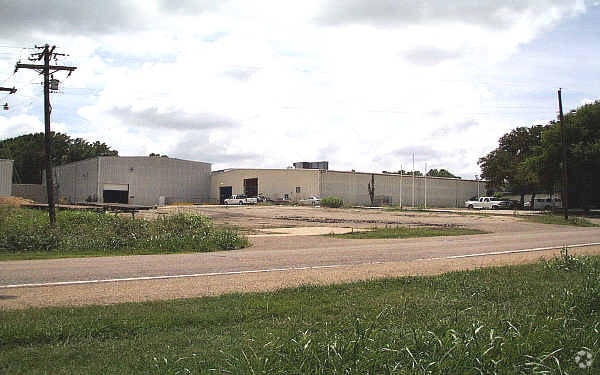
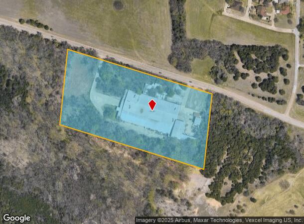
600 W Belt Line Rd
65017228010280000
E Bader
Officebuilding
E BADER ABST 172 PG 280 TR 28 ACS 11.1805 INT201700141740 DD05182017 CO-DC 0172280102800 4CN01722801
X
Dallas
48139C0060G
Texas
2024
11.18 AC
2025
SE Dallas/I-45
016802
Dallas/Ft Worth
94,596 SF
Dallas-Fort Worth-Arlington, TX
DEMOGRAPHICS near 600 W Belt Line Rd
1 Mile
3 Mile
5 Mile
2024 Total Population
4,133
32,821
87,307
2029 Population
4,076
32,508
90,309
Pop Growth 2024-2029
(1.38%)
(0.95%)
+ 3.44%
Average Age
38
36
37
2024 Total Households
1,351
10,894
29,119
HH Growth 2024-2029
(1.55%)
(1.24%)
+ 3.25%
Median Household Inc
$60,243
$59,210
$65,870
Avg Household Size
2.90
3.00
2.90
2024 Avg HH Vehicles
2.00
2.00
2.00
Median Home Value
$200,347
$182,582
$205,694
Median Year Built
1980
1989
1991
Nearby Places
Map Layers
Map Styles
 Street
 Aerial
- Restaurants
- Banks
- Shops
- Fitness
- Groceries
PUBLIC TRANSPORTATION
AIRPORT
Dallas Love Field
DRIVE
WALK
Distance
Dallas Love Field
35 min
23.1 mi
Dallas-Fort Worth International
DRIVE
WALK
Distance
Dallas-Fort Worth International
48 min
36.8 mi
Nearby Properties
Address
Land Use
TOTAL SIZE
Lot Size
Zoning
Address
Land Use
TOTAL SIZE
Lot Size
Zoning
2,492,806 SF
273.09 AC
Z34
Address
Land Use
TOTAL SIZE
Lot Size
Zoning
241,034 SF
301.97 AC
Z298
Address
Land Use
TOTAL SIZE
Lot Size
Zoning
1,225,000 SF
69.44 AC
Z04
Address
Land Use
TOTAL SIZE
Lot Size
Zoning
735,000 SF
159.91 AC
Z04
Address
Land Use
TOTAL SIZE
Lot Size
Zoning
1,015,340 SF
55.63 AC
Z239
Address
Land Use
TOTAL SIZE
Lot Size
Zoning
799,529 SF
56.34 AC
Address
Land Use
TOTAL SIZE
Lot Size
Zoning
753,200 SF
52.61 AC
Z239
Address
Land Use
TOTAL SIZE
Lot Size
Zoning
506,285 SF
26.49 AC
Address
Land Use
TOTAL SIZE
Lot Size
Zoning
615,060 SF
53.36 AC
Z125
Address
Land Use
TOTAL SIZE
Lot Size
Zoning
160,003 SF
29.67 AC
Z350
Address
Land Use
TOTAL SIZE
Lot Size
Zoning
78,200 SF
6.93 AC
Z239
Address
Land Use
TOTAL SIZE
Lot Size
Zoning
103,340 SF
219.50 AC
Z04
Address
Land Use
TOTAL SIZE
Lot Size
Zoning
61,671 SF
88.78 AC
Z345
Address
Land Use
TOTAL SIZE
Lot Size
Zoning
94,407 SF
11.68 AC
Z239
Address
Land Use
TOTAL SIZE
Lot Size
Zoning
298,000 SF
21.24 AC
Z175
Address
Land Use
TOTAL SIZE
Lot Size
Zoning
269,955 SF
16.18 AC
Z125
Address
Land Use
TOTAL SIZE
Lot Size
Zoning
178,250 SF
32.89 AC
Address
Land Use
TOTAL SIZE
Lot Size
Zoning
231,646 SF
36.66 AC
Z125
Address
Land Use
TOTAL SIZE
Lot Size
Zoning
182,220 SF
9.25 AC
Z175
Address
Land Use
TOTAL SIZE
Lot Size
Zoning
86,200 SF
9.50 AC
Z239
Address
Land Use
TOTAL SIZE
Lot Size
Zoning
207,120 SF
10 AC
Z175
Address
Land Use
TOTAL SIZE
Lot Size
Zoning
550,137 SF
43.30 AC
Z239
Address
Land Use
TOTAL SIZE
Lot Size
Zoning
364,306 SF
50.27 AC
Z04
Address
Land Use
TOTAL SIZE
Lot Size
Zoning
130,128 SF
14.47 AC
Z175
Address
Land Use
TOTAL SIZE
Lot Size
Zoning
181,393 SF
12.40 AC
Address
Land Use
TOTAL SIZE
Lot Size
Zoning
184,000 SF
10.32 AC
Address
Land Use
TOTAL SIZE
Lot Size
Zoning
125,588 SF
7.66 AC
Z175
Address
Land Use
TOTAL SIZE
Lot Size
Zoning
100 SF
98.88 AC
Z350
Address
Land Use
TOTAL SIZE
Lot Size
Zoning
1,000 SF
198.52 AC
Z34
Address
Land Use
TOTAL SIZE
Lot Size
Zoning
272,000 SF
38.53 AC
The World's #1 Commercial Real Estate Marketplace
Connect with us
© 2025 CoStar Group
The information above has been obtained from sources believed reliable. While we do not doubt its accuracy we have not verified it and make no guarantee, warranty or representation about it. It is your responsibility to independently confirm its accuracy and completeness. Any projections, opinions, assumptions, or estimates used are for example only and do not represent the current or future performance of the property. The value of this transaction to you depends on tax and other factors which should be evaluated by your tax, financial, and legal advisors. You and your advisors should conduct a careful, independent investigation of the property to determine to your satisfaction the suitability of the property for your needs.