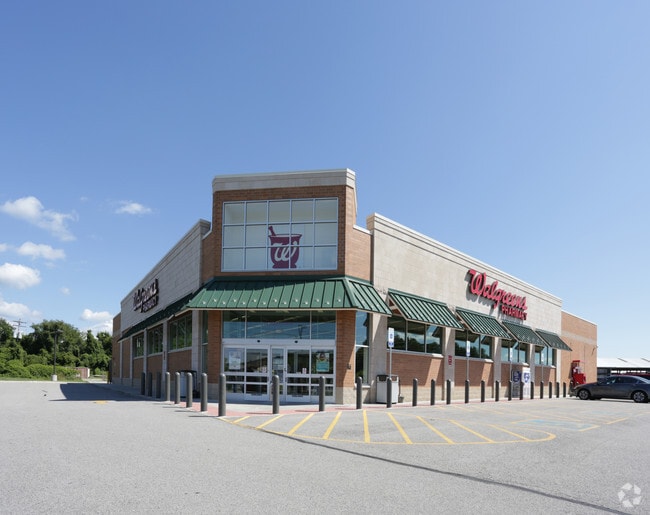
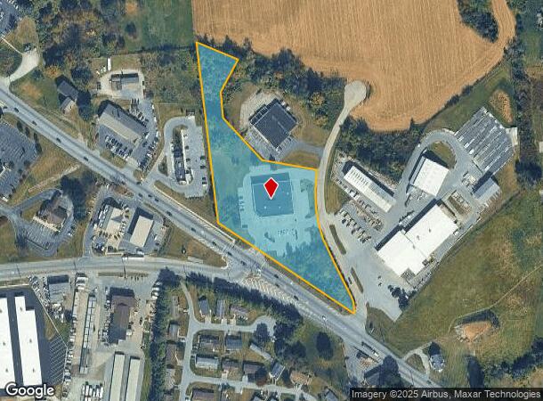
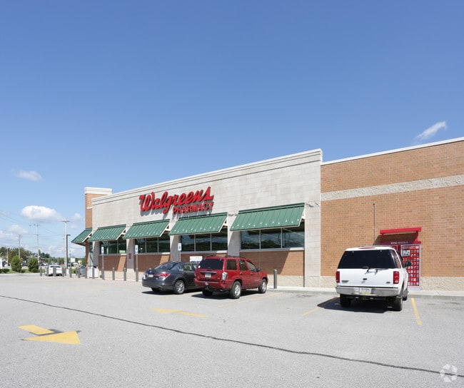
Property Record
600 W London Grove Rd, Avondale, PA 19311
NEARBY LISTINGS FOR SALE OR LEASE
Property Detail
600 W London Grove Rd
Philadelphia-Camden-Wilmington, PA-NJ-DE-MD
William F Butler Jr & Margaret
59-005-0117.01D0
4.2 AC & COMM BLDG LOT 1
Commercialnec
Chester
X
Pennsylvania
42029C0290G
1
2024
4.25 AC
2025
Outer Chester County
306504
Philadelphia
14,945 SF
DEMOGRAPHICS near 600 W London Grove Rd
1 Mile
3 Mile
5 Mile
2024 Total Population
2,529
16,884
42,750
2029 Population
2,580
17,434
44,521
Pop Growth 2024-2029
+ 2.02%
+ 3.26%
+ 4.14%
Average Age
36
38
40
2024 Total Households
762
5,284
14,582
HH Growth 2024-2029
+ 2.23%
+ 3.44%
+ 4.38%
Median Household Inc
$75,446
$108,131
$110,822
Avg Household Size
3.30
3.10
2.80
2024 Avg HH Vehicles
2.00
2.00
2.00
Median Home Value
$329,899
$372,741
$405,159
Median Year Built
1973
1990
1990
Nearby Places
Map Layers
Map Styles
 Street
 Aerial
- Restaurants
- Banks
- Shops
- Fitness
- Groceries
PUBLIC TRANSPORTATION
AIRPORT
Philadelphia International
DRIVE
WALK
Distance
Philadelphia International
52 min
32.8 mi
Freight Ports
Port of Wilmington, RI
DRIVE
WALK
Distance
Port of Wilmington, RI
35 min
19.7 mi
Nearby Properties
Address
Land Use
TOTAL SIZE
Lot Size
Zoning
Address
Land Use
TOTAL SIZE
Lot Size
Zoning
309,221 SF
66 AC
RR
Address
Land Use
TOTAL SIZE
Lot Size
Zoning
258,320 SF
42.68 AC
CI
Address
Land Use
TOTAL SIZE
Lot Size
Zoning
105,405 SF
17 AC
R1
Address
Land Use
TOTAL SIZE
Lot Size
Zoning
152,629 SF
152.30 AC
ES1
Address
Land Use
TOTAL SIZE
Lot Size
Zoning
451,182 SF
94.70 AC
BP
Address
Land Use
TOTAL SIZE
Lot Size
Zoning
66,899 SF
21.40 AC
RR
Address
Land Use
TOTAL SIZE
Lot Size
Zoning
200,337 SF
14 AC
CI
Address
Land Use
TOTAL SIZE
Lot Size
Zoning
52,779 SF
14.50 AC
RR
Address
Land Use
TOTAL SIZE
Lot Size
Zoning
87,680 SF
11.40 AC
CI
Address
Land Use
TOTAL SIZE
Lot Size
Zoning
50,234 SF
16.40 AC
RR
Address
Land Use
TOTAL SIZE
Lot Size
Zoning
106,200 SF
10.40 AC
CI
Address
Land Use
TOTAL SIZE
Lot Size
Zoning
262,839 SF
59.75 AC
R1
Address
Land Use
TOTAL SIZE
Lot Size
Zoning
13,784 SF
214.02 AC
AC
Address
Land Use
TOTAL SIZE
Lot Size
Zoning
66,184 SF
16 AC
ES1
Address
Land Use
TOTAL SIZE
Lot Size
Zoning
58,773 SF
11.04 AC
CI
Address
Land Use
TOTAL SIZE
Lot Size
Zoning
29,614 SF
28.29 AC
R1
Address
Land Use
TOTAL SIZE
Lot Size
Zoning
150,423 SF
44.22 AC
R1
Address
Land Use
TOTAL SIZE
Lot Size
Zoning
50,846 SF
10 AC
CI
Address
Land Use
TOTAL SIZE
Lot Size
Zoning
64,044 SF
69.21 AC
BP
Address
Land Use
TOTAL SIZE
Lot Size
Zoning
100,807 SF
83.99 AC
BP
Address
Land Use
TOTAL SIZE
Lot Size
Zoning
21,910 SF
8.75 AC
R1
Address
Land Use
TOTAL SIZE
Lot Size
Zoning
25,537 SF
15.20 AC
I
Address
Land Use
TOTAL SIZE
Lot Size
Zoning
26,274 SF
1.81 AC
R1
Address
Land Use
TOTAL SIZE
Lot Size
Zoning
13,092 SF
2.60 AC
CI
Address
Land Use
TOTAL SIZE
Lot Size
Zoning
56,509 SF
7.48 AC
AC
Address
Land Use
TOTAL SIZE
Lot Size
Zoning
112,968 SF
39.50 AC
RR
Address
Land Use
TOTAL SIZE
Lot Size
Zoning
111,794 SF
40.45 AC
I
Address
Land Use
TOTAL SIZE
Lot Size
Zoning
74,496 SF
17.40 AC
R1
Address
Land Use
TOTAL SIZE
Lot Size
Zoning
76,738 SF
40 AC
AG
The World's #1 Commercial Real Estate Marketplace
Connect with us
© 2025 CoStar Group
The information above has been obtained from sources believed reliable. While we do not doubt its accuracy we have not verified it and make no guarantee, warranty or representation about it. It is your responsibility to independently confirm its accuracy and completeness. Any projections, opinions, assumptions, or estimates used are for example only and do not represent the current or future performance of the property. The value of this transaction to you depends on tax and other factors which should be evaluated by your tax, financial, and legal advisors. You and your advisors should conduct a careful, independent investigation of the property to determine to your satisfaction the suitability of the property for your needs.