Property Record
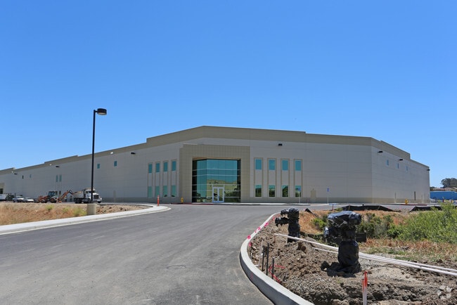
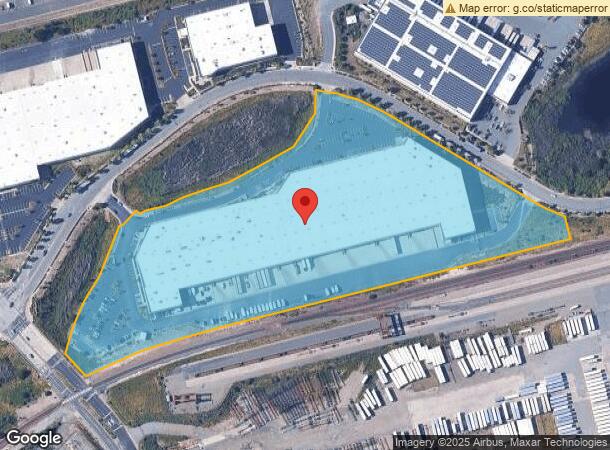
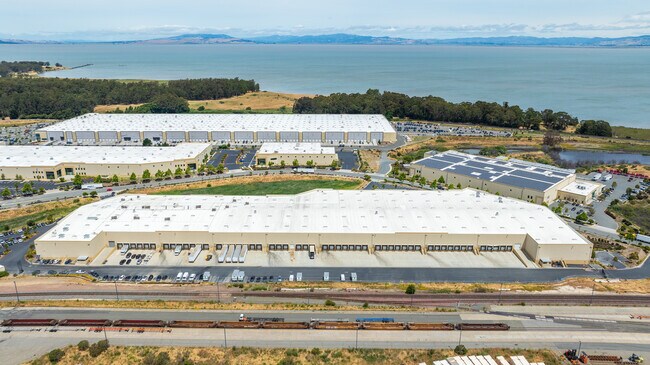
6000 Giant Rd, San Pablo, CA 94806

Current Lease Availabilities
NEARBY LISTINGS FOR SALE OR LEASE
Property Detail
6000 Giant Rd
Oakland-Fremont-Berkeley, CA
Subdivision 8414
405-030-052-6
TR 8414 LTS 4 & 5
Industrialpark
Contra Costa
X
California
06013C0226G
4,5
2025
14.36 AC
2025
Richmond/San Pablo
392201
East Bay/Oakland
247,924 SF
DEMOGRAPHICS near 6000 Giant Rd
1 Mile
3 Mile
5 Mile
2024 Total Population
7,188
76,292
194,452
2029 Population
7,101
75,522
192,501
Pop Growth 2024-2029
(1.21%)
(1.01%)
(1.00%)
Average Age
38
39
39
2024 Total Households
2,092
24,582
62,566
HH Growth 2024-2029
(1.29%)
(1.10%)
(1.07%)
Median Household Inc
$100,218
$81,724
$87,431
Avg Household Size
3.20
3.00
3.00
2024 Avg HH Vehicles
2.00
2.00
2.00
Median Home Value
$673,636
$641,183
$680,449
Median Year Built
1996
1969
1966
Nearby Places
Map Layers
Map Styles
 Street
 Aerial
- Restaurants
- Banks
- Shops
- Fitness
- Groceries
PUBLIC TRANSPORTATION
COMMUTER RAIL
Richmond (Capitol Corridor - Capitol Corridor Joint Powers Authority)
DRIVE
WALK
Distance
Richmond (Capitol Corridor - Capitol Corridor Joint Powers Authority)
12 min
5.7 mi
AIRPORT
Metro Oakland International
DRIVE
WALK
Distance
Metro Oakland International
37 min
26.6 mi
San Francisco International
DRIVE
WALK
Distance
San Francisco International
50 min
34.2 mi
Freight Ports
Port of Richmond
DRIVE
WALK
Distance
Port of Richmond
18 min
9.8 mi
Nearby Properties
Address
Land Use
TOTAL SIZE
Lot Size
Zoning
Address
Land Use
TOTAL SIZE
Lot Size
Zoning
892,224 SF
46.87 AC
Address
Land Use
TOTAL SIZE
Lot Size
Zoning
707,820 SF
44.29 AC
Address
Land Use
TOTAL SIZE
Lot Size
Zoning
481,487 SF
27.88 AC
P-1
Address
Land Use
TOTAL SIZE
Lot Size
Zoning
205,900 SF
20.70 AC
P1
Address
Land Use
TOTAL SIZE
Lot Size
Zoning
321,008 SF
47.36 AC
Address
Land Use
TOTAL SIZE
Lot Size
Zoning
252,714 SF
14.68 AC
C
Address
Land Use
TOTAL SIZE
Lot Size
Zoning
459,003 SF
21.30 AC
Address
Land Use
TOTAL SIZE
Lot Size
Zoning
179,961 SF
1.05 AC
Address
Land Use
TOTAL SIZE
Lot Size
Zoning
245,680 SF
18.89 AC
Address
Land Use
TOTAL SIZE
Lot Size
Zoning
200,000 SF
14.95 AC
Address
Land Use
TOTAL SIZE
Lot Size
Zoning
70,250 SF
9.55 AC
Address
Land Use
TOTAL SIZE
Lot Size
Zoning
220,864 SF
11.10 AC
Address
Land Use
TOTAL SIZE
Lot Size
Zoning
190,471 SF
11.32 AC
Address
Land Use
TOTAL SIZE
Lot Size
Zoning
171,052 SF
12.06 AC
M3
Address
Land Use
TOTAL SIZE
Lot Size
Zoning
135,904 SF
7.12 AC
Address
Land Use
TOTAL SIZE
Lot Size
Zoning
113,346 SF
10.11 AC
Address
Land Use
TOTAL SIZE
Lot Size
Zoning
41,400 SF
6.32 AC
Address
Land Use
TOTAL SIZE
Lot Size
Zoning
177,724 SF
63.32 AC
M-2
Address
Land Use
TOTAL SIZE
Lot Size
Zoning
118,658 SF
8.57 AC
Address
Land Use
TOTAL SIZE
Lot Size
Zoning
178,277 SF
58.72 AC
Address
Land Use
TOTAL SIZE
Lot Size
Zoning
131,693 SF
7.47 AC
Address
Land Use
TOTAL SIZE
Lot Size
Zoning
144,000 SF
7.64 AC
Address
Land Use
TOTAL SIZE
Lot Size
Zoning
110,765 SF
2.67 AC
Address
Land Use
TOTAL SIZE
Lot Size
Zoning
60,196 SF
13.44 AC
Address
Land Use
TOTAL SIZE
Lot Size
Zoning
61,403 SF
8.38 AC
Address
Land Use
TOTAL SIZE
Lot Size
Zoning
7.06 AC
P1
Address
Land Use
TOTAL SIZE
Lot Size
Zoning
97,116 SF
7.26 AC
Address
Land Use
TOTAL SIZE
Lot Size
Zoning
72,927 SF
3.47 AC
Address
Land Use
TOTAL SIZE
Lot Size
Zoning
6,440 SF
8.14 AC
The World's #1 Commercial Real Estate Marketplace
Connect with us
© 2026 CoStar Group
The information above has been obtained from sources believed reliable. While we do not doubt its accuracy we have not verified it and make no guarantee, warranty or representation about it. It is your responsibility to independently confirm its accuracy and completeness. Any projections, opinions, assumptions, or estimates used are for example only and do not represent the current or future performance of the property. The value of this transaction to you depends on tax and other factors which should be evaluated by your tax, financial, and legal advisors. You and your advisors should conduct a careful, independent investigation of the property to determine to your satisfaction the suitability of the property for your needs.