Property Record
6000 Old Lansing Rd, Lansing, MI 48917
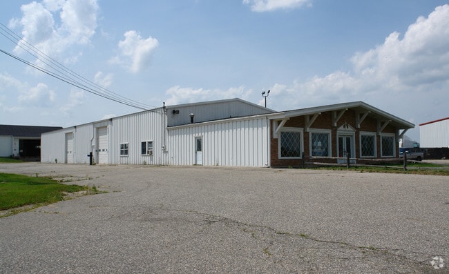

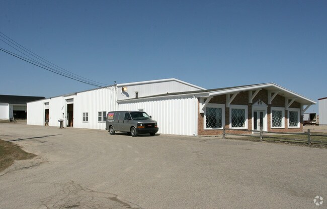
Property Detail
6000 Old Lansing Rd
040-035-100-211-00
A PARCEL OF LAND IN THE NORTHWEST 1/4 OF SECTION 35 DESCRIBED AS: COMMENCING AT THE WEST 1/4 CORNER OF SECTION 35, THENCE
Storebuilding
Eaton
NONE
Michigan
B and X Area of moderate flood hazard, usually the area between the limits of the 100-year and 500-year floods.
2.07 AC
2025
Southern Lansing
2026
West Michigan
020202
Lansing-East Lansing, MI
15,662 SF
NEARBY LISTINGS FOR SALE OR LEASE
DEMOGRAPHICS near 6000 Old Lansing Rd
1 mile
3 mile
5 mile
2025 Total Population
346
29,596
104,659
2030 Population
346
29,743
105,253
Pop Growth 2025-2030
0.00%
+ 0.50%
+ 0.57%
Average Age
43
41
40
2025 Total Households
148
12,245
45,307
HH Growth 2025-2030
0.00%
+ 0.51%
+ 0.60%
Median Household Inc
$44,499
$62,868
$62,279
Avg Household Size
2.30
2.30
2.20
2025 Avg HH Vehicles
2.00
2.00
2.00
Median Home Value
$192,221
$184,493
$176,393
Median Year Built
1956
1972
1969
Nearby Places
Map Layers
Map Styles
 Street
 Aerial
Layers
 Traffic
 Biking
Places
Listings with unknown addresses are not visible on the map
- Restaurants
- Banks
- Shops
- Fitness
- Groceries
PUBLIC TRANSPORTATION
COMMUTER RAIL
East Lansing Amtrak Station (Blue Water - Amtrak)
Drive
Walk
Distance
East Lansing Amtrak Station (Blue Water - Amtrak)
13 min
8.7 mi
AIRPORT
Capital Region International
Drive
Walk
Distance
Capital Region International
14 min
7.6 mi
Freight Ports
Port of Toledo
Drive
Walk
Distance
Port of Toledo
150 min
128.7 mi
Nearby Properties
Address
Land Use
TOTAL SIZE
Lot Size
Zoning
Address
Land Use
TOTAL SIZE
Lot Size
Zoning
Address
Land Use
TOTAL SIZE
Lot Size
Zoning
4,395,257 SF
324 AC
I HVY
Address
Land Use
TOTAL SIZE
Lot Size
Zoning
1,085,633 SF
115.14 AC
NONE
Address
Land Use
TOTAL SIZE
Lot Size
Zoning
628,230 SF
38.20 AC
NONE
Address
Land Use
TOTAL SIZE
Lot Size
Zoning
166,083 SF
39.98 AC
NONE
Address
Land Use
TOTAL SIZE
Lot Size
Zoning
286.23 AC
NONE
Address
Land Use
TOTAL SIZE
Lot Size
Zoning
1,059,295 SF
139.28 AC
NONE
Address
Land Use
TOTAL SIZE
Lot Size
Zoning
389,485 SF
30.04 AC
NONE
Address
Land Use
TOTAL SIZE
Lot Size
Zoning
217,664 SF
61.37 AC
NONE
Address
Land Use
TOTAL SIZE
Lot Size
Zoning
198,225 SF
11.54 AC
NONE
Address
Land Use
TOTAL SIZE
Lot Size
Zoning
2,276,790 SF
96.93 AC
NONE
Address
Land Use
TOTAL SIZE
Lot Size
Zoning
628,651 SF
34.29 AC
NONE
Address
Land Use
TOTAL SIZE
Lot Size
Zoning
231,000 SF
26 AC
Address
Land Use
TOTAL SIZE
Lot Size
Zoning
292,918 SF
I-FAC
Address
Land Use
TOTAL SIZE
Lot Size
Zoning
111,804 SF
80 AC
NONE
Address
Land Use
TOTAL SIZE
Lot Size
Zoning
824,570 SF
47.65 AC
NONE
Address
Land Use
TOTAL SIZE
Lot Size
Zoning
219,176 SF
9.45 AC
NONE
Address
Land Use
TOTAL SIZE
Lot Size
Zoning
50,364 SF
25.57 AC
M-1
Address
Land Use
TOTAL SIZE
Lot Size
Zoning
144,630 SF
11.51 AC
M-1
Address
Land Use
TOTAL SIZE
Lot Size
Zoning
14,505 SF
90 AC
Address
Land Use
TOTAL SIZE
Lot Size
Zoning
269,800 SF
20.10 AC
NONE
Address
Land Use
TOTAL SIZE
Lot Size
Zoning
146,200 SF
5.41 AC
NONE
Address
Land Use
TOTAL SIZE
Lot Size
Zoning
250,100 SF
25.45 AC
NONE
Address
Land Use
TOTAL SIZE
Lot Size
Zoning
160,000 SF
16.18 AC
Address
Land Use
TOTAL SIZE
Lot Size
Zoning
106,344 SF
10.69 AC
NONE
Address
Land Use
TOTAL SIZE
Lot Size
Zoning
404,215 SF
40 AC
NONE
Address
Land Use
TOTAL SIZE
Lot Size
Zoning
151,542 SF
6.76 AC
NONE
Address
Land Use
TOTAL SIZE
Lot Size
Zoning
53,147 SF
15.70 AC
C
Address
Land Use
TOTAL SIZE
Lot Size
Zoning
133,280 SF
27.22 AC
Address
Land Use
TOTAL SIZE
Lot Size
Zoning
147,234 SF
17.13 AC
NONE
The World's #1 Commercial Real Estate Marketplace
Connect with us
© 2026 CoStar Group
The information above has been obtained from sources believed reliable. While we do not doubt its accuracy we have not verified it and make no guarantee, warranty or representation about it. It is your responsibility to independently confirm its accuracy and completeness. Any projections, opinions, assumptions, or estimates used are for example only and do not represent the current or future performance of the property. The value of this transaction to you depends on tax and other factors which should be evaluated by your tax, financial, and legal advisors. You and your advisors should conduct a careful, independent investigation of the property to determine to your satisfaction the suitability of the property for your needs.