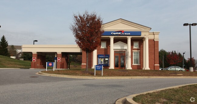
Property Record
6000 Marshalee Dr, Elkridge, MD 21075


Save to a Folder
{{folder.Name}}
{{folder.ListingIds.length}} Properties
{{folder.ListingIds.length}} Property
Create a New Folder
Property Detail
6000 Marshalee Dr
01-275003
PAR A1 10.1473 A 6000 MARSHALEE DR R/W LYN SQ RSB LYN MAN S1 A1
Communitycenter
HOWARD
B2PEC
Maryland
B and X Area of moderate flood hazard, usually the area between the limits of the 100-year and 500-year floods.
a 1
2025
10.14 AC
2025
Columbia North
601103
Baltimore
19,660 SF
Baltimore-Columbia-Towson, MD
NEARBY LISTINGS FOR SALE OR LEASE
DEMOGRAPHICS near 6000 Marshalee Dr
1 mile
3 mile
5 mile
2025 Total Population
10,107
81,671
195,877
2030 Population
10,282
82,836
198,363
Pop Growth 2025-2030
+ 1.73%
+ 1.43%
+ 1.27%
Average Age
39
38
39
2025 Total Households
3,543
29,049
72,099
HH Growth 2025-2030
+ 1.89%
+ 1.43%
+ 1.28%
Median Household Inc
$173,697
$138,528
$129,817
Avg Household Size
2.80
2.70
2.60
2025 Avg HH Vehicles
2.00
2.00
2.00
Median Home Value
$495,509
$498,039
$480,797
Median Year Built
1993
1993
1988
Nearby Places
Map Layers
Map Styles
 Street
 Aerial
Layers
 Traffic
 Biking
Places
Listings with unknown addresses are not visible on the map
- Restaurants
- Banks
- Shops
- Fitness
- Groceries
PUBLIC TRANSPORTATION
COMMUTER RAIL
Dorsey Marc Sb (CAMDEN - WASHINGTON - Maryland Transit Administration)
Drive
Walk
Distance
Dorsey Marc Sb (CAMDEN - WASHINGTON - Maryland Transit Administration)
9 min
4.8 mi
Dorsey Marc Nb (CAMDEN - WASHINGTON - Maryland Transit Administration)
Drive
Walk
Distance
Dorsey Marc Nb (CAMDEN - WASHINGTON - Maryland Transit Administration)
9 min
4.8 mi
AIRPORT
Baltimore/Washington International Thurgood Marshall
Drive
Walk
Distance
Baltimore/Washington International Thurgood Marshall
17 min
11.2 mi
Ronald Reagan Washington Ntl
Drive
Walk
Distance
Ronald Reagan Washington Ntl
53 min
34.2 mi
Freight Ports
Port of Baltimore
Drive
Walk
Distance
Port of Baltimore
22 min
14.0 mi
SALE & LEASE HISTORY
LISTING DATE
SALE/LEASE

Jul 28, 2017
For Lease
Aug 27, 2019
For Lease
Nearby Properties
Address
Land Use
TOTAL SIZE
Lot Size
Zoning
Address
Land Use
TOTAL SIZE
Lot Size
Zoning
31,730 SF
43.99 AC
RA15
Address
Land Use
TOTAL SIZE
Lot Size
Zoning
120,108 SF
28.23 AC
TOD
Address
Land Use
TOTAL SIZE
Lot Size
Zoning
154,666 SF
27.65 AC
M1
Address
Land Use
TOTAL SIZE
Lot Size
Zoning
77,028 SF
18.68 AC
NT
Address
Land Use
TOTAL SIZE
Lot Size
Zoning
87,344 SF
5.46 AC
CECLI
Address
Land Use
TOTAL SIZE
Lot Size
Zoning
307,626 SF
5.46 AC
CACLI
Address
Land Use
TOTAL SIZE
Lot Size
Zoning
988,378 SF
115.55 AC
M1
Address
Land Use
TOTAL SIZE
Lot Size
Zoning
256,156 SF
14.56 AC
M1
Address
Land Use
TOTAL SIZE
Lot Size
Zoning
21,240 SF
20.31 AC
RA 15
Address
Land Use
TOTAL SIZE
Lot Size
Zoning
14,040 SF
10.86 AC
RA15
Address
Land Use
TOTAL SIZE
Lot Size
Zoning
309,703 SF
39.71 AC
R20
Address
Land Use
TOTAL SIZE
Lot Size
Zoning
370,240 SF
4.18 AC
CACLI
Address
Land Use
TOTAL SIZE
Lot Size
Zoning
202,692 SF
4.28 AC
TOD
Address
Land Use
TOTAL SIZE
Lot Size
Zoning
359,185 SF
3.63 AC
TOD
Address
Land Use
TOTAL SIZE
Lot Size
Zoning
55,400 SF
10.19 AC
CACLI
Address
Land Use
TOTAL SIZE
Lot Size
Zoning
56,584 SF
12.03 AC
RA15
Address
Land Use
TOTAL SIZE
Lot Size
Zoning
236,935 SF
37.08 AC
M1
Address
Land Use
TOTAL SIZE
Lot Size
Zoning
79,448 SF
8.11 AC
TOD
Address
Land Use
TOTAL SIZE
Lot Size
Zoning
307,032 SF
4.35 AC
TOD
Address
Land Use
TOTAL SIZE
Lot Size
Zoning
53,024 SF
10.02 AC
CACLI
Address
Land Use
TOTAL SIZE
Lot Size
Zoning
271,600 SF
30.43 AC
M1
Address
Land Use
TOTAL SIZE
Lot Size
Zoning
133,600 SF
11.75 AC
NT
Address
Land Use
TOTAL SIZE
Lot Size
Zoning
234,007 SF
49.96 AC
NT
Address
Land Use
TOTAL SIZE
Lot Size
Zoning
151,844 SF
5.77 AC
CACLI
Address
Land Use
TOTAL SIZE
Lot Size
Zoning
132,552 SF
47.72 AC
RED
Address
Land Use
TOTAL SIZE
Lot Size
Zoning
157,672 SF
14.16 AC
B2
Address
Land Use
TOTAL SIZE
Lot Size
Zoning
160,000 SF
12.19 AC
NT
Address
Land Use
TOTAL SIZE
Lot Size
Zoning
32,000 SF
26.24 AC
NT
Address
Land Use
TOTAL SIZE
Lot Size
Zoning
180,914 SF
11.28 AC
M2
Address
Land Use
TOTAL SIZE
Lot Size
Zoning
697,152 SF
48.69 AC
M1
The World's #1 Commercial Real Estate Marketplace
Connect with us
© 2026 CoStar Group
The information above has been obtained from sources believed reliable. While we do not doubt its accuracy we have not verified it and make no guarantee, warranty or representation about it. It is your responsibility to independently confirm its accuracy and completeness. Any projections, opinions, assumptions, or estimates used are for example only and do not represent the current or future performance of the property. The value of this transaction to you depends on tax and other factors which should be evaluated by your tax, financial, and legal advisors. You and your advisors should conduct a careful, independent investigation of the property to determine to your satisfaction the suitability of the property for your needs.