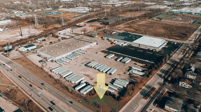
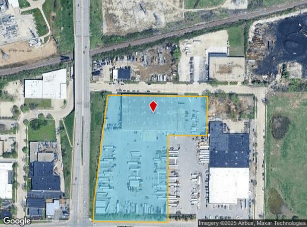
Property Record
6000 N 76Th St, Milwaukee, WI 53218
Current Lease Availabilities
NEARBY LISTINGS FOR SALE OR LEASE
Property Detail
6000 N 76Th St
Milwaukee-Waukesha-West Allis, WI
Cert Surv Map 4538
154-0042-000-6
CERTIFIED SURVEY MAP NO 4538 IN NW 1/4 SEC 27-8-21 PARCEL 2 BID #31
Warehouse
Milwaukee
X
Wisconsin
55089C0245G
2
2024
7.54 AC
2024
Milwaukee NW
001300
Milwaukee/Madison
70,000 SF
DEMOGRAPHICS near 6000 N 76Th St
1 Mile
3 Mile
5 Mile
2024 Total Population
18,275
124,054
285,881
2029 Population
17,961
121,864
281,535
Pop Growth 2024-2029
(1.72%)
(1.77%)
(1.52%)
Average Age
33
36
37
2024 Total Households
6,405
47,143
114,208
HH Growth 2024-2029
(1.84%)
(1.83%)
(1.63%)
Median Household Inc
$40,827
$46,336
$51,442
Avg Household Size
2.70
2.50
2.40
2024 Avg HH Vehicles
1.00
1.00
1.00
Median Home Value
$123,292
$136,640
$171,143
Median Year Built
1958
1958
1956
Nearby Places
- Restaurants
- Banks
- Shops
- Fitness
- Groceries
PUBLIC TRANSPORTATION
AIRPORT
General Mitchell International
DRIVE
WALK
Distance
General Mitchell International
33 min
18.0 mi
Freight Ports
Port of Baltimore
DRIVE
WALK
Distance
Port of Baltimore
1 min
649.8 mi
Nearby Properties
Address
Land Use
TOTAL SIZE
Lot Size
Zoning
Address
Land Use
TOTAL SIZE
Lot Size
Zoning
33.49 AC
TL
Address
Land Use
TOTAL SIZE
Lot Size
Zoning
197,426 SF
26.34 AC
PD
Address
Land Use
TOTAL SIZE
Lot Size
Zoning
206,529 SF
7.88 AC
PD
Address
Land Use
TOTAL SIZE
Lot Size
Zoning
298,666 SF
5.09 AC
PD
Address
Land Use
TOTAL SIZE
Lot Size
Zoning
326,619 SF
30.69 AC
PD
Address
Land Use
TOTAL SIZE
Lot Size
Zoning
12.49 AC
TL
Address
Land Use
TOTAL SIZE
Lot Size
Zoning
104,365 SF
9.85 AC
PD
Address
Land Use
TOTAL SIZE
Lot Size
Zoning
66.42 AC
IL1
Address
Land Use
TOTAL SIZE
Lot Size
Zoning
17.84 AC
TL
Address
Land Use
TOTAL SIZE
Lot Size
Zoning
140,757 SF
19.08 AC
PD
Address
Land Use
TOTAL SIZE
Lot Size
Zoning
221,548 SF
11.80 AC
PD
Address
Land Use
TOTAL SIZE
Lot Size
Zoning
93.72 AC
PK
Address
Land Use
TOTAL SIZE
Lot Size
Zoning
169,550 SF
12.04 AC
RB2
Address
Land Use
TOTAL SIZE
Lot Size
Zoning
21,516 SF
11.86 AC
IL1
Address
Land Use
TOTAL SIZE
Lot Size
Zoning
18.54 AC
RS6
Address
Land Use
TOTAL SIZE
Lot Size
Zoning
7,420 SF
18.06 AC
IL1
Address
Land Use
TOTAL SIZE
Lot Size
Zoning
17.91 AC
RS5
Address
Land Use
TOTAL SIZE
Lot Size
Zoning
297,894 SF
19.67 AC
IL1
Address
Land Use
TOTAL SIZE
Lot Size
Zoning
333,971 SF
16.93 AC
IL1
Address
Land Use
TOTAL SIZE
Lot Size
Zoning
166,245 SF
55 AC
PD
Address
Land Use
TOTAL SIZE
Lot Size
Zoning
28.12 AC
RM1
Address
Land Use
TOTAL SIZE
Lot Size
Zoning
116,862 SF
14.39 AC
RM1
Address
Land Use
TOTAL SIZE
Lot Size
Zoning
23.38 AC
RS6
Address
Land Use
TOTAL SIZE
Lot Size
Zoning
163,539 SF
7.17 AC
PUD
Address
Land Use
TOTAL SIZE
Lot Size
Zoning
49.03 AC
PK
Address
Land Use
TOTAL SIZE
Lot Size
Zoning
88,259 SF
14.70 AC
PD
Address
Land Use
TOTAL SIZE
Lot Size
Zoning
9.94 AC
IL1
Address
Land Use
TOTAL SIZE
Lot Size
Zoning
92,303 SF
19.02 AC
PD
Address
Land Use
TOTAL SIZE
Lot Size
Zoning
118,520 SF
7.69 AC
RM1
Address
Land Use
TOTAL SIZE
Lot Size
Zoning
73,748 SF
5.76 AC
PD
The World's #1 Commercial Real Estate Marketplace
Connect with us
© 2025 CoStar Group
The information above has been obtained from sources believed reliable. While we do not doubt its accuracy we have not verified it and make no guarantee, warranty or representation about it. It is your responsibility to independently confirm its accuracy and completeness. Any projections, opinions, assumptions, or estimates used are for example only and do not represent the current or future performance of the property. The value of this transaction to you depends on tax and other factors which should be evaluated by your tax, financial, and legal advisors. You and your advisors should conduct a careful, independent investigation of the property to determine to your satisfaction the suitability of the property for your needs.