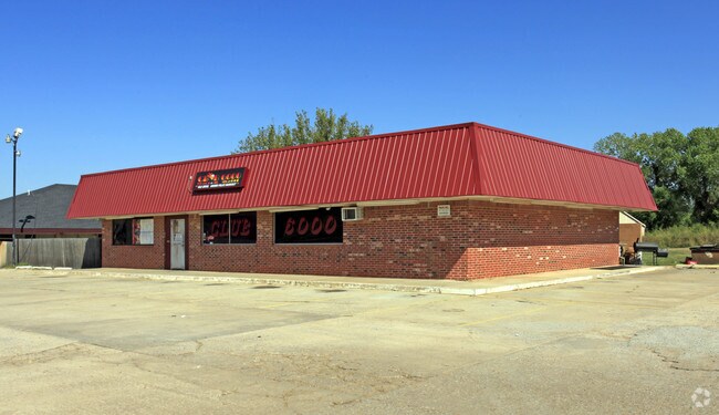
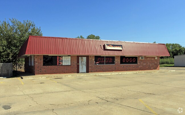
Property Record
6000 N Bryant Ave, Oklahoma City, OK 73121

NEARBY LISTINGS FOR SALE OR LEASE
Property Detail
6000 N Bryant Ave
141712670
Unpltd Pt Sec 07 12N 2W
Motel
UNPLTD PT NW4 SEC 7 12N 2W BEG IN CNTR OF BRYANT AVE & 1336FT S OF NW/C NW4 TH E450FT S230.61FT W89.27FT NW31.68FT W157.80FT N17.25FT W51.53FT N23.96FT NW28.55FT W96.78FT N162.71FT TO BEG
X
Oklahoma
40109C0190H
Oklahoma
2023
2.13 AC
2024
East Oklahoma County
106000
Oklahoma City
23,305 SF
Oklahoma City, OK
DEMOGRAPHICS near 6000 N Bryant Ave
1 Mile
3 Mile
5 Mile
2024 Total Population
317
16,977
77,771
2029 Population
318
17,526
80,557
Pop Growth 2024-2029
+ 0.32%
+ 3.23%
+ 3.58%
Average Age
47
41
39
2024 Total Households
129
7,020
34,828
HH Growth 2024-2029
+ 0.78%
+ 3.32%
+ 3.69%
Median Household Inc
$88,586
$41,289
$48,245
Avg Household Size
2.30
2.20
2.10
2024 Avg HH Vehicles
2.00
2.00
2.00
Median Home Value
$230,769
$168,238
$196,200
Median Year Built
1957
1961
1963
Nearby Places
Map Layers
Map Styles
 Street
 Aerial
- Restaurants
- Banks
- Shops
- Fitness
- Groceries
PUBLIC TRANSPORTATION
COMMUTER RAIL
Oklahoma City (Heartland Flyer - Amtrak)
DRIVE
WALK
Distance
Oklahoma City (Heartland Flyer - Amtrak)
11 min
7.7 mi
AIRPORT
Will Rogers World
DRIVE
WALK
Distance
Will Rogers World
28 min
17.1 mi
Freight Ports
Tulsa Port Of Catoosa
DRIVE
WALK
Distance
Tulsa Port Of Catoosa
126 min
116.7 mi
Nearby Properties
Address
Land Use
TOTAL SIZE
Lot Size
Zoning
Address
Land Use
TOTAL SIZE
Lot Size
Zoning
442,553 SF
58.86 AC
PUD
Address
Land Use
TOTAL SIZE
Lot Size
Zoning
327,248 SF
14.22 AC
R-4
Address
Land Use
TOTAL SIZE
Lot Size
Zoning
93,244 SF
7.54 AC
PUD
Address
Land Use
TOTAL SIZE
Lot Size
Zoning
241,874 SF
36.89 AC
PUD
Address
Land Use
TOTAL SIZE
Lot Size
Zoning
377,880 SF
24.34 AC
PUD
Address
Land Use
TOTAL SIZE
Lot Size
Zoning
21,000 SF
2.64 AC
I-1
Address
Land Use
TOTAL SIZE
Lot Size
Zoning
280,970 SF
24.32 AC
Address
Land Use
TOTAL SIZE
Lot Size
Zoning
145,124 SF
55 AC
PUD
Address
Land Use
TOTAL SIZE
Lot Size
Zoning
39,800 SF
4.10 AC
PUD
Address
Land Use
TOTAL SIZE
Lot Size
Zoning
316,358 SF
39.39 AC
PUD
Address
Land Use
TOTAL SIZE
Lot Size
Zoning
198,422 SF
4.17 AC
O-2
Address
Land Use
TOTAL SIZE
Lot Size
Zoning
142,592 SF
6.60 AC
PUD
Address
Land Use
TOTAL SIZE
Lot Size
Zoning
160,816 SF
16.14 AC
Address
Land Use
TOTAL SIZE
Lot Size
Zoning
160,849 SF
11.65 AC
C-3
Address
Land Use
TOTAL SIZE
Lot Size
Zoning
151,319 SF
3.43 AC
O-2
Address
Land Use
TOTAL SIZE
Lot Size
Zoning
46,390 SF
14.13 AC
Address
Land Use
TOTAL SIZE
Lot Size
Zoning
131,180 SF
12.90 AC
I-2
Address
Land Use
TOTAL SIZE
Lot Size
Zoning
30,501 SF
2.48 AC
R-1
Address
Land Use
TOTAL SIZE
Lot Size
Zoning
110,172 SF
33.65 AC
PUD
Address
Land Use
TOTAL SIZE
Lot Size
Zoning
7,360 SF
4.69 AC
SPUD
Address
Land Use
TOTAL SIZE
Lot Size
Zoning
104,186 SF
21.32 AC
R-4
Address
Land Use
TOTAL SIZE
Lot Size
Zoning
111,924 SF
10.83 AC
SPUD
Address
Land Use
TOTAL SIZE
Lot Size
Zoning
84,116 SF
5.68 AC
R-4
Address
Land Use
TOTAL SIZE
Lot Size
Zoning
6,000 SF
2.24 AC
C-3
Address
Land Use
TOTAL SIZE
Lot Size
Zoning
54,680 SF
2.20 AC
O-2
Address
Land Use
TOTAL SIZE
Lot Size
Zoning
50,042 SF
150 AC
Address
Land Use
TOTAL SIZE
Lot Size
Zoning
32,717 SF
85 AC
AA
Address
Land Use
TOTAL SIZE
Lot Size
Zoning
156,300 SF
24.99 AC
PUD
Address
Land Use
TOTAL SIZE
Lot Size
Zoning
11,179 SF
20.92 AC
PUD
Address
Land Use
TOTAL SIZE
Lot Size
Zoning
62,409 SF
7.46 AC
SPUD
The World's #1 Commercial Real Estate Marketplace
Connect with us
© 2026 CoStar Group
The information above has been obtained from sources believed reliable. While we do not doubt its accuracy we have not verified it and make no guarantee, warranty or representation about it. It is your responsibility to independently confirm its accuracy and completeness. Any projections, opinions, assumptions, or estimates used are for example only and do not represent the current or future performance of the property. The value of this transaction to you depends on tax and other factors which should be evaluated by your tax, financial, and legal advisors. You and your advisors should conduct a careful, independent investigation of the property to determine to your satisfaction the suitability of the property for your needs.