Property Record
6000 S Park Ln, Spokane, WA 99223


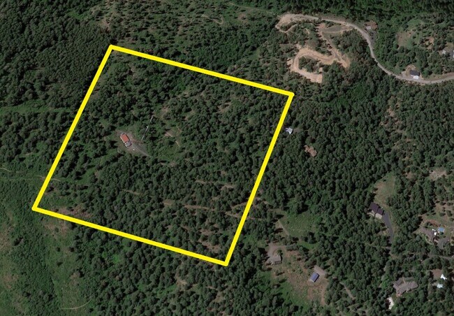
This Property Is For Sale
NEARBY LISTINGS FOR SALE OR LEASE
Property Detail
6000 S Park Ln
Spokane-Spokane Valley, WA
GOVERNMENT LOT13
44063.9022
Spokane
Timberlandforesttreesagricultural
Washington
X
13
53063C0731D
43.50 AC
2025
Valley
2025
Spokane
013300
DEMOGRAPHICS near 6000 S Park Ln
1 Mile
3 Mile
5 Mile
2024 Total Population
191
19,176
105,326
2029 Population
205
20,613
112,824
Pop Growth 2024-2029
+ 7.33%
+ 7.49%
+ 7.12%
Average Age
46
43
42
2024 Total Households
71
7,497
42,167
HH Growth 2024-2029
+ 7.04%
+ 7.56%
+ 7.19%
Median Household Inc
$155,357
$111,799
$82,599
Avg Household Size
2.70
2.50
2.40
2024 Avg HH Vehicles
3.00
2.00
2.00
Median Home Value
$750,000
$535,815
$439,258
Median Year Built
1991
1991
1977
Nearby Places
Map Layers
Map Styles
 Street
 Aerial
- Restaurants
- Banks
- Shops
- Fitness
- Groceries
PUBLIC TRANSPORTATION
COMMUTER RAIL
Spokane (Empire Builder - Amtrak)
DRIVE
WALK
Distance
Spokane (Empire Builder - Amtrak)
25 min
9.4 mi
AIRPORT
Spokane International
DRIVE
WALK
Distance
Spokane International
33 min
15.3 mi
Freight Ports
Port of Everett
DRIVE
WALK
Distance
Port of Everett
361 min
310.9 mi
Nearby Properties
Address
Land Use
TOTAL SIZE
Lot Size
Zoning
Address
Land Use
TOTAL SIZE
Lot Size
Zoning
218,684 SF
13.29 AC
RMF
Address
Land Use
TOTAL SIZE
Lot Size
Zoning
135,715 SF
4.73 AC
RMF
Address
Land Use
TOTAL SIZE
Lot Size
Zoning
69,202 SF
9.99 AC
R-2
Address
Land Use
TOTAL SIZE
Lot Size
Zoning
173,714 SF
9.98 AC
HDR
Address
Land Use
TOTAL SIZE
Lot Size
Zoning
142,500 SF
6.86 AC
RMF
Address
Land Use
TOTAL SIZE
Lot Size
Zoning
172,388 SF
13.59 AC
RSF
Address
Land Use
TOTAL SIZE
Lot Size
Zoning
55,623 SF
4.46 AC
MU
Address
Land Use
TOTAL SIZE
Lot Size
Zoning
144,382 SF
5.43 AC
CC2
Address
Land Use
TOTAL SIZE
Lot Size
Zoning
121,962 SF
3.80 AC
RMF
Address
Land Use
TOTAL SIZE
Lot Size
Zoning
79,855 SF
4.13 AC
RMF
Address
Land Use
TOTAL SIZE
Lot Size
Zoning
40,340 SF
4.87 AC
RSF
Address
Land Use
TOTAL SIZE
Lot Size
Zoning
58,647 SF
5.19 AC
MF-2
Address
Land Use
TOTAL SIZE
Lot Size
Zoning
82,487 SF
4.76 AC
CC
Address
Land Use
TOTAL SIZE
Lot Size
Zoning
93,552 SF
4.18 AC
HDR
Address
Land Use
TOTAL SIZE
Lot Size
Zoning
50,407 SF
13.13 AC
LDR
Address
Land Use
TOTAL SIZE
Lot Size
Zoning
50,124 SF
4.17 AC
HDR
Address
Land Use
TOTAL SIZE
Lot Size
Zoning
52,706 SF
6.48 AC
MU
Address
Land Use
TOTAL SIZE
Lot Size
Zoning
69,485 SF
5.63 AC
CC
Address
Land Use
TOTAL SIZE
Lot Size
Zoning
359.36 AC
RCV
Address
Land Use
TOTAL SIZE
Lot Size
Zoning
62,710 SF
4.11 AC
CC
Address
Land Use
TOTAL SIZE
Lot Size
Zoning
21,530 SF
2.19 AC
HDR
Address
Land Use
TOTAL SIZE
Lot Size
Zoning
30,848 SF
1.24 AC
Address
Land Use
TOTAL SIZE
Lot Size
Zoning
160 AC
RCV
Address
Land Use
TOTAL SIZE
Lot Size
Zoning
49,883 SF
3.62 AC
CC
Address
Land Use
TOTAL SIZE
Lot Size
Zoning
39,312 SF
2.68 AC
RMF
Address
Land Use
TOTAL SIZE
Lot Size
Zoning
29,448 SF
1.11 AC
R-3
Address
Land Use
TOTAL SIZE
Lot Size
Zoning
2,112 SF
18.31 AC
Address
Land Use
TOTAL SIZE
Lot Size
Zoning
190 AC
RCV
Address
Land Use
TOTAL SIZE
Lot Size
Zoning
121.75 AC
RCV
Address
Land Use
TOTAL SIZE
Lot Size
Zoning
19,170 SF
8.16 AC
LDR
The World's #1 Commercial Real Estate Marketplace
Connect with us
© 2026 CoStar Group
The information above has been obtained from sources believed reliable. While we do not doubt its accuracy we have not verified it and make no guarantee, warranty or representation about it. It is your responsibility to independently confirm its accuracy and completeness. Any projections, opinions, assumptions, or estimates used are for example only and do not represent the current or future performance of the property. The value of this transaction to you depends on tax and other factors which should be evaluated by your tax, financial, and legal advisors. You and your advisors should conduct a careful, independent investigation of the property to determine to your satisfaction the suitability of the property for your needs.