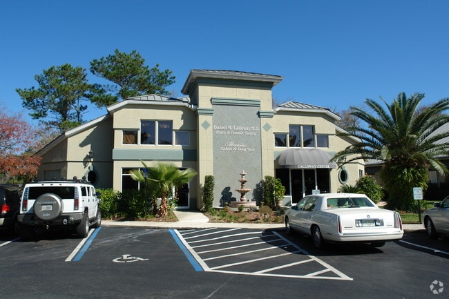
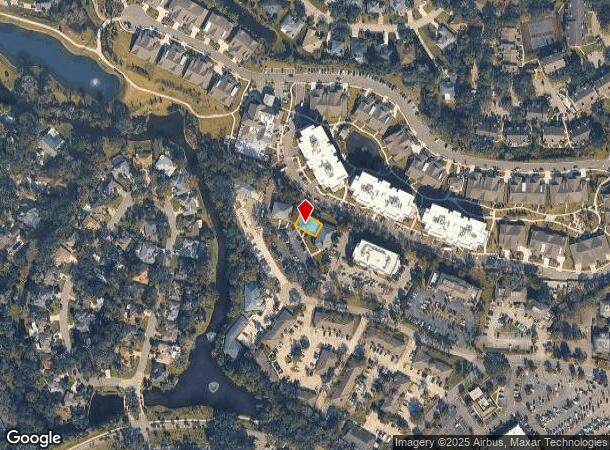
Property Record
6000 Sawgrass Village Cir, Ponte Vedra Beach, FL 32082

NEARBY LISTINGS FOR SALE OR LEASE
Property Detail
6000 Sawgrass Village Cir
Jacksonville, FL
Christina Hill
062280-0121
1-12A PT OF SEC 50 LYING N OF SAWGRASS VILLAGE DRIVE & S OF OAK BRIDGE GOLF COURSE 80.33 X 47FT - BLDG B OR5815/332
Librarymuseum
St. Johns
AE
Florida
12109C0084J
1-12a
2023
0.09 AC
2025
Beaches
020705
Jacksonville (Florida)
5,993 SF
DEMOGRAPHICS near 6000 Sawgrass Village Cir
1 Mile
3 Mile
5 Mile
2024 Total Population
8,397
25,983
47,330
2029 Population
11,040
34,292
59,001
Pop Growth 2024-2029
+ 31.48%
+ 31.98%
+ 24.66%
Average Age
49
48
46
2024 Total Households
3,899
11,243
20,505
HH Growth 2024-2029
+ 31.19%
+ 31.65%
+ 23.99%
Median Household Inc
$110,704
$122,172
$120,014
Avg Household Size
2.10
2.30
2.30
2024 Avg HH Vehicles
2.00
2.00
2.00
Median Home Value
$629,727
$662,967
$625,205
Median Year Built
1987
1989
1991
Nearby Places
- Restaurants
- Banks
- Shops
- Fitness
- Groceries
PUBLIC TRANSPORTATION
AIRPORT
Jacksonville International
DRIVE
WALK
Distance
Jacksonville International
50 min
34.4 mi
Freight Ports
Jacksonville Port
DRIVE
WALK
Distance
Jacksonville Port
41 min
25.1 mi
SALE & LEASE HISTORY
LISTING DATE
SALE/LEASE

Jul 11, 2022
For Sale
Nearby Properties
Address
Land Use
TOTAL SIZE
Lot Size
Zoning
Address
Land Use
TOTAL SIZE
Lot Size
Zoning
199,463 SF
131.13 AC
PUD
Address
Land Use
TOTAL SIZE
Lot Size
Zoning
198,533 SF
9.59 AC
Address
Land Use
TOTAL SIZE
Lot Size
Zoning
159,780 SF
35.73 AC
PUD
Address
Land Use
TOTAL SIZE
Lot Size
Zoning
398,312 SF
39.43 AC
Address
Land Use
TOTAL SIZE
Lot Size
Zoning
422,503 SF
285.32 AC
R2
Address
Land Use
TOTAL SIZE
Lot Size
Zoning
433,943 SF
24.90 AC
PUD
Address
Land Use
TOTAL SIZE
Lot Size
Zoning
256,228 SF
19.47 AC
PUD
Address
Land Use
TOTAL SIZE
Lot Size
Zoning
384,314 SF
24.30 AC
PUD
Address
Land Use
TOTAL SIZE
Lot Size
Zoning
129,840 SF
496.26 AC
PUD
Address
Land Use
TOTAL SIZE
Lot Size
Zoning
118,725 SF
4.37 AC
R2
Address
Land Use
TOTAL SIZE
Lot Size
Zoning
127,691 SF
36.98 AC
PUD
Address
Land Use
TOTAL SIZE
Lot Size
Zoning
69,171 SF
263.69 AC
PUD
Address
Land Use
TOTAL SIZE
Lot Size
Zoning
80,034 SF
7 AC
PUD
Address
Land Use
TOTAL SIZE
Lot Size
Zoning
76,140 SF
14.30 AC
RG1
Address
Land Use
TOTAL SIZE
Lot Size
Zoning
62,405 SF
7.77 AC
Address
Land Use
TOTAL SIZE
Lot Size
Zoning
89,365 SF
1.54 AC
PUD
Address
Land Use
TOTAL SIZE
Lot Size
Zoning
22,248 SF
3.82 AC
R3
Address
Land Use
TOTAL SIZE
Lot Size
Zoning
152,288 SF
2.61 AC
PUD
Address
Land Use
TOTAL SIZE
Lot Size
Zoning
76,729 SF
5 AC
OR
Address
Land Use
TOTAL SIZE
Lot Size
Zoning
76,556 SF
0.87 AC
PUD
Address
Land Use
TOTAL SIZE
Lot Size
Zoning
53,383 SF
6.71 AC
PUD
Address
Land Use
TOTAL SIZE
Lot Size
Zoning
9,759 SF
1.99 AC
R3
Address
Land Use
TOTAL SIZE
Lot Size
Zoning
9,868 SF
1.93 AC
R1B
Address
Land Use
TOTAL SIZE
Lot Size
Zoning
156,788 SF
33.79 AC
R1C
Address
Land Use
TOTAL SIZE
Lot Size
Zoning
43,182 SF
11.51 AC
PUD
Address
Land Use
TOTAL SIZE
Lot Size
Zoning
63,128 SF
0.78 AC
PUD
Address
Land Use
TOTAL SIZE
Lot Size
Zoning
58,707 SF
0.82 AC
PUD
Address
Land Use
TOTAL SIZE
Lot Size
Zoning
29,781 SF
10.15 AC
R2
Address
Land Use
TOTAL SIZE
Lot Size
Zoning
47,357 SF
5.37 AC
R3
Address
Land Use
TOTAL SIZE
Lot Size
Zoning
51,520 SF
2.17 AC
R2
The World's #1 Commercial Real Estate Marketplace
Connect with us
© 2025 CoStar Group
The information above has been obtained from sources believed reliable. While we do not doubt its accuracy we have not verified it and make no guarantee, warranty or representation about it. It is your responsibility to independently confirm its accuracy and completeness. Any projections, opinions, assumptions, or estimates used are for example only and do not represent the current or future performance of the property. The value of this transaction to you depends on tax and other factors which should be evaluated by your tax, financial, and legal advisors. You and your advisors should conduct a careful, independent investigation of the property to determine to your satisfaction the suitability of the property for your needs.