Property Record
6001 S 35Th St, Mcallen, TX 78503

Save to a Folder
{{folder.Name}}
{{folder.ListingIds.length}} Properties
{{folder.ListingIds.length}} Property
Create a New Folder
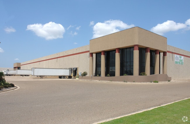
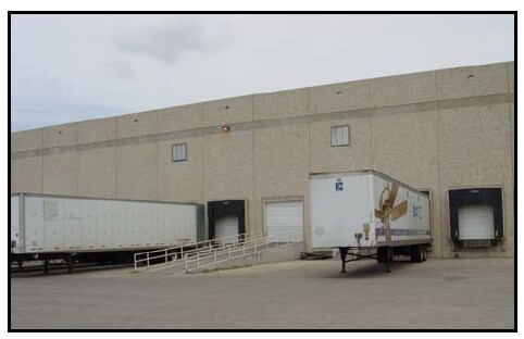
Property Detail
6001 S 35Th St
McAllen-Edinburg-Mission, TX
SOUTH WEST CENTRE LOT 7A
S4775-00-000-007A-00
Hidalgo
Warehouse
Texas
C
7a
2024
9.86 AC
2025
Greater McAllen
020509
McAllen/Edinburg/Pharr
129,065 SF
NEARBY LISTINGS FOR SALE OR LEASE
DEMOGRAPHICS near 6001 S 35Th St
1 mile
3 mile
5 mile
2025 Total Population
5,682
28,402
132,371
2030 Population
5,794
29,361
139,052
Pop Growth 2025-2030
+ 1.97%
+ 3.38%
+ 5.05%
Average Age
34
35
37
2025 Total Households
1,568
8,498
42,208
HH Growth 2025-2030
+ 1.72%
+ 3.17%
+ 5.24%
Median Household Inc
$40,465
$56,801
$54,220
Avg Household Size
3.40
3.30
3.00
2025 Avg HH Vehicles
2.00
2.00
2.00
Median Home Value
$143,220
$198,049
$167,866
Median Year Built
1999
2002
1999
Nearby Places
Map Layers
Map Styles
 Street
 Aerial
Layers
 Traffic
 Biking
Places
Listings with unknown addresses are not visible on the map
- Restaurants
- Banks
- Shops
- Fitness
- Groceries
PUBLIC TRANSPORTATION
AIRPORT
McAllen International
Drive
Walk
Distance
McAllen International
10 min
5.0 mi
Freight Ports
Port of Brownsville
Drive
Walk
Distance
Port of Brownsville
76 min
64.2 mi
SALE & LEASE HISTORY
LISTING DATE
SALE/LEASE

Sep 25, 2016
For Lease
Feb 25, 2020
For Lease
Aug 29, 2017
For Lease
Nearby Properties
Address
Land Use
TOTAL SIZE
Lot Size
Zoning
Address
Land Use
TOTAL SIZE
Lot Size
Zoning
1,199,590 SF
47.93 AC
Address
Land Use
TOTAL SIZE
Lot Size
Zoning
291,859 SF
10.11 AC
CO
Address
Land Use
TOTAL SIZE
Lot Size
Zoning
354,558 SF
26.79 AC
Address
Land Use
TOTAL SIZE
Lot Size
Zoning
208,941 SF
18.57 AC
Address
Land Use
TOTAL SIZE
Lot Size
Zoning
16,600 SF
23.27 AC
Address
Land Use
TOTAL SIZE
Lot Size
Zoning
105,440 SF
19.84 AC
Address
Land Use
TOTAL SIZE
Lot Size
Zoning
236,124 SF
14.03 AC
Address
Land Use
TOTAL SIZE
Lot Size
Zoning
287,691 SF
33.57 AC
Address
Land Use
TOTAL SIZE
Lot Size
Zoning
3,000 SF
16 AC
Address
Land Use
TOTAL SIZE
Lot Size
Zoning
158,844 SF
36.09 AC
Address
Land Use
TOTAL SIZE
Lot Size
Zoning
73,507 SF
23.84 AC
Address
Land Use
TOTAL SIZE
Lot Size
Zoning
323,400 SF
17.29 AC
Address
Land Use
TOTAL SIZE
Lot Size
Zoning
370,000 SF
24.54 AC
Address
Land Use
TOTAL SIZE
Lot Size
Zoning
177,334 SF
10.31 AC
Address
Land Use
TOTAL SIZE
Lot Size
Zoning
289,443 SF
12.91 AC
CO
Address
Land Use
TOTAL SIZE
Lot Size
Zoning
215,000 SF
17.80 AC
Address
Land Use
TOTAL SIZE
Lot Size
Zoning
59,078 SF
12.65 AC
CO
Address
Land Use
TOTAL SIZE
Lot Size
Zoning
288,657 SF
16.75 AC
IN
Address
Land Use
TOTAL SIZE
Lot Size
Zoning
69,184 SF
2.94 AC
Address
Land Use
TOTAL SIZE
Lot Size
Zoning
285,360 SF
13.67 AC
CO
Address
Land Use
TOTAL SIZE
Lot Size
Zoning
352,000 SF
18 AC
Address
Land Use
TOTAL SIZE
Lot Size
Zoning
370,736 SF
16.52 AC
Address
Land Use
TOTAL SIZE
Lot Size
Zoning
251,422 SF
15.01 AC
Address
Land Use
TOTAL SIZE
Lot Size
Zoning
46,195 SF
13.58 AC
Address
Land Use
TOTAL SIZE
Lot Size
Zoning
71,964 SF
2.22 AC
CO
Address
Land Use
TOTAL SIZE
Lot Size
Zoning
240,292 SF
38.55 AC
RS
Address
Land Use
TOTAL SIZE
Lot Size
Zoning
1 SF
12.30 AC
GT
Address
Land Use
TOTAL SIZE
Lot Size
Zoning
103,741 SF
3.09 AC
Address
Land Use
TOTAL SIZE
Lot Size
Zoning
216,116 SF
13.21 AC
IN
Address
Land Use
TOTAL SIZE
Lot Size
Zoning
203,970 SF
10.04 AC
The World's #1 Commercial Real Estate Marketplace
Connect with us
© 2026 CoStar Group
The information above has been obtained from sources believed reliable. While we do not doubt its accuracy we have not verified it and make no guarantee, warranty or representation about it. It is your responsibility to independently confirm its accuracy and completeness. Any projections, opinions, assumptions, or estimates used are for example only and do not represent the current or future performance of the property. The value of this transaction to you depends on tax and other factors which should be evaluated by your tax, financial, and legal advisors. You and your advisors should conduct a careful, independent investigation of the property to determine to your satisfaction the suitability of the property for your needs.