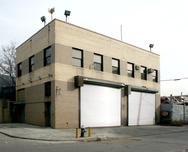
Property Record
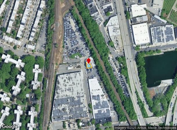
6002 30Th Ave, Woodside, NY 11377
NEARBY LISTINGS FOR SALE OR LEASE
Property Detail
6002 30Th Ave
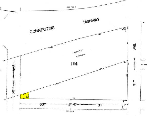
01114-0050
Queens
Autorepair
New York
X
50
3604970094F
0.05 AC
2024
Northwest Queens
2025
Long Island (New York)
029700
New York-Jersey City-White Plains, NY-NJ
4,000 SF
DEMOGRAPHICS near 6002 30Th Ave
1 mile
3 mile
5 mile
2024 Total Population
129,968
869,366
2,826,874
2029 Population
122,162
813,578
2,639,490
Pop Growth 2024-2029
(6.01%)
(6.42%)
(6.63%)
Average Age
41
40
40
2024 Total Households
51,495
344,457
1,177,464
HH Growth 2024-2029
(6.14%)
(6.51%)
(6.93%)
Median Household Inc
$75,487
$78,360
$74,827
Avg Household Size
2.50
2.40
2.30
2024 Avg HH Vehicles
1.00
1.00
.00
Median Home Value
$691,589
$740,556
$811,087
Median Year Built
1949
1955
1955
Nearby Places
Map Layers
Map Styles
 Street
 Aerial
Transit
 Traffic
 Biking
Places
Listings with unknown addresses are not visible on the map
- Restaurants
- Banks
- Shops
- Fitness
- Groceries
PUBLIC TRANSPORTATION
TRANSIT/SUBWAY
Northern Boulevard (E - New York MTA Subway (The Subway), M - New York MTA Subway (The Subway), R - New York MTA Subway (The Subway))
Drive
Walk
Distance
Northern Boulevard (E - New York MTA Subway (The Subway), M - New York MTA Subway (The Subway), R - New York MTA Subway (The Subway))
2 min
13 min
0.7 mi
46 Street (E - New York MTA Subway (The Subway), M - New York MTA Subway (The Subway), R - New York MTA Subway (The Subway))
Drive
Walk
Distance
46 Street (E - New York MTA Subway (The Subway), M - New York MTA Subway (The Subway), R - New York MTA Subway (The Subway))
4 min
16 min
0.8 mi
65 Street (E - New York MTA Subway (The Subway), M - New York MTA Subway (The Subway), R - New York MTA Subway (The Subway))
Drive
Walk
Distance
65 Street (E - New York MTA Subway (The Subway), M - New York MTA Subway (The Subway), R - New York MTA Subway (The Subway))
3 min
17 min
0.9 mi
COMMUTER RAIL
Woodside Station (Babylon Branch - Long Island Rail Road, Far Rockaway Branch - Long Island Rail Road, Hempstead Branch - Long Island Rail Road, Long Beach Branch - Long Island Rail Road, Montauk Branch - Long Island Rail Road, Port Jefferson Branch - Long Island Rail Road, Port Washington Branch - Long Island Rail Road, Ronkonkoma Branch - Long Island Rail Road)
Drive
Walk
Distance
Woodside Station (Babylon Branch - Long Island Rail Road, Far Rockaway Branch - Long Island Rail Road, Hempstead Branch - Long Island Rail Road, Long Beach Branch - Long Island Rail Road, Montauk Branch - Long Island Rail Road, Port Jefferson Branch - Long Island Rail Road, Port Washington Branch - Long Island Rail Road, Ronkonkoma Branch - Long Island Rail Road)
4 min
20 min
1.0 mi
Hunterspoint Avenue Station (Hempstead Branch - Long Island Rail Road, Oyster Bay Branch - Long Island Rail Road)
Drive
Walk
Distance
Hunterspoint Avenue Station (Hempstead Branch - Long Island Rail Road, Oyster Bay Branch - Long Island Rail Road)
10 min
3.3 mi
AIRPORT
LaGuardia
Drive
Walk
Distance
LaGuardia
6 min
2.3 mi
John F Kennedy International
Drive
Walk
Distance
John F Kennedy International
21 min
13.6 mi
Newark Liberty International
Drive
Walk
Distance
Newark Liberty International
35 min
20.9 mi
Freight Ports
NY - Red Hook Container Terminal
Drive
Walk
Distance
NY - Red Hook Container Terminal
19 min
9.7 mi
Nearby Properties
Address
Land Use
TOTAL SIZE
Lot Size
Zoning
Address
Land Use
TOTAL SIZE
Lot Size
Zoning
97.14 AC
R7-2
Address
Land Use
TOTAL SIZE
Lot Size
Zoning
1.22 AC
R7-2
Address
Land Use
TOTAL SIZE
Lot Size
Zoning
0.92 AC
R7-2
Address
Land Use
TOTAL SIZE
Lot Size
Zoning
97.14 AC
R7-2
Address
Land Use
TOTAL SIZE
Lot Size
Zoning
4,380,201 SF
97.06 AC
R7-2
Address
Land Use
TOTAL SIZE
Lot Size
Zoning
5,519,372 SF
409.21 AC
C8-2
Address
Land Use
TOTAL SIZE
Lot Size
Zoning
2,230,742 SF
6.33 AC
R9
Address
Land Use
TOTAL SIZE
Lot Size
Zoning
1,258,350 SF
410.24 AC
PARK
Address
Land Use
TOTAL SIZE
Lot Size
Zoning
1,200,000 SF
10.24 AC
R9
Address
Land Use
TOTAL SIZE
Lot Size
Zoning
1,065,915 SF
2.13 AC
M16R10
Address
Land Use
TOTAL SIZE
Lot Size
Zoning
700,000 SF
2.25 AC
R7-2
Address
Land Use
TOTAL SIZE
Lot Size
Zoning
700,000 SF
2.25 AC
R7-2
Address
Land Use
TOTAL SIZE
Lot Size
Zoning
700,000 SF
2.25 AC
R7-2
Address
Land Use
TOTAL SIZE
Lot Size
Zoning
700,000 SF
2.25 AC
R7-2
Address
Land Use
TOTAL SIZE
Lot Size
Zoning
700,000 SF
2.25 AC
R7-2
Address
Land Use
TOTAL SIZE
Lot Size
Zoning
700,000 SF
2.25 AC
R7-2
Address
Land Use
TOTAL SIZE
Lot Size
Zoning
700,000 SF
2.25 AC
R7-2
Address
Land Use
TOTAL SIZE
Lot Size
Zoning
700,000 SF
2.25 AC
R7-2
Address
Land Use
TOTAL SIZE
Lot Size
Zoning
700,000 SF
2.25 AC
R7-2
Address
Land Use
TOTAL SIZE
Lot Size
Zoning
700,000 SF
2.25 AC
R7-2
Address
Land Use
TOTAL SIZE
Lot Size
Zoning
11.92 AC
R7-2
Address
Land Use
TOTAL SIZE
Lot Size
Zoning
11.92 AC
R7-2
Address
Land Use
TOTAL SIZE
Lot Size
Zoning
11.92 AC
R7-2
Address
Land Use
TOTAL SIZE
Lot Size
Zoning
11.92 AC
R7-2
Address
Land Use
TOTAL SIZE
Lot Size
Zoning
11.92 AC
R7-2
Address
Land Use
TOTAL SIZE
Lot Size
Zoning
11.92 AC
R7-2
Address
Land Use
TOTAL SIZE
Lot Size
Zoning
11.92 AC
R7-2
Address
Land Use
TOTAL SIZE
Lot Size
Zoning
11.92 AC
R7-2
Address
Land Use
TOTAL SIZE
Lot Size
Zoning
11.92 AC
R7-2
Address
Land Use
TOTAL SIZE
Lot Size
Zoning
11.92 AC
R7-2
The World's #1 Commercial Real Estate Marketplace
Connect with us
© 2026 CoStar Group
The information above has been obtained from sources believed reliable. While we do not doubt its accuracy we have not verified it and make no guarantee, warranty or representation about it. It is your responsibility to independently confirm its accuracy and completeness. Any projections, opinions, assumptions, or estimates used are for example only and do not represent the current or future performance of the property. The value of this transaction to you depends on tax and other factors which should be evaluated by your tax, financial, and legal advisors. You and your advisors should conduct a careful, independent investigation of the property to determine to your satisfaction the suitability of the property for your needs.