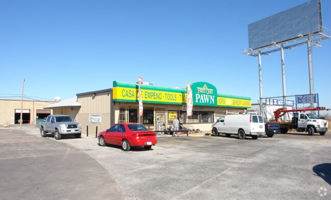
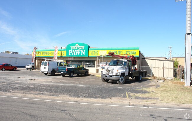
Property Record
6005 Airport Fwy, Haltom City, TX 76117
NEARBY LISTINGS FOR SALE OR LEASE
Property Detail
6005 Airport Fwy
Dallas-Fort Worth-Arlington, TX
Parkdale Gardens Addition
02123029
PARKDALE GARDENS ADDITION BLOCK 17 LOT 14 NW TRI 14 BLK 17
Residentialacreage
Tarrant
AE
Texas
48439C0195L
14
2024
0.06 AC
2025
Haltom City
110301
Dallas/Ft Worth
DEMOGRAPHICS near 6005 Airport Fwy
1 Mile
3 Mile
5 Mile
2024 Total Population
3,848
79,800
246,898
2029 Population
4,049
84,219
261,714
Pop Growth 2024-2029
+ 5.22%
+ 5.54%
+ 6.00%
Average Age
36
37
37
2024 Total Households
1,295
28,616
89,524
HH Growth 2024-2029
+ 5.25%
+ 5.69%
+ 6.16%
Median Household Inc
$41,021
$51,804
$55,450
Avg Household Size
2.90
2.70
2.70
2024 Avg HH Vehicles
2.00
2.00
2.00
Median Home Value
$174,171
$193,625
$205,729
Median Year Built
1960
1967
1975
Nearby Places
Map Layers
Map Styles
 Street
 Aerial
- Restaurants
- Banks
- Shops
- Fitness
- Groceries
PUBLIC TRANSPORTATION
COMMUTER RAIL
Richland Hills (Trinity Railway Express - Dallas Area Rapid Transit (DART))
DRIVE
WALK
Distance
Richland Hills (Trinity Railway Express - Dallas Area Rapid Transit (DART))
5 min
2.7 mi
DRIVE
WALK
Distance
6 min
3.2 mi
AIRPORT
Dallas-Fort Worth International
DRIVE
WALK
Distance
Dallas-Fort Worth International
27 min
19.6 mi
Dallas Love Field
DRIVE
WALK
Distance
Dallas Love Field
38 min
28.3 mi
Nearby Properties
Address
Land Use
TOTAL SIZE
Lot Size
Zoning
Address
Land Use
TOTAL SIZE
Lot Size
Zoning
231,871 SF
17.08 AC
Address
Land Use
TOTAL SIZE
Lot Size
Zoning
459,540 SF
36.02 AC
Address
Land Use
TOTAL SIZE
Lot Size
Zoning
221,946 SF
31.17 AC
Address
Land Use
TOTAL SIZE
Lot Size
Zoning
197,131 SF
43.78 AC
Address
Land Use
TOTAL SIZE
Lot Size
Zoning
241,064 SF
12.63 AC
Address
Land Use
TOTAL SIZE
Lot Size
Zoning
526,195 SF
40.84 AC
Address
Land Use
TOTAL SIZE
Lot Size
Zoning
306,524 SF
24.92 AC
Address
Land Use
TOTAL SIZE
Lot Size
Zoning
141,276 SF
12.04 AC
Address
Land Use
TOTAL SIZE
Lot Size
Zoning
228,667 SF
12.17 AC
Address
Land Use
TOTAL SIZE
Lot Size
Zoning
125,838 SF
12.38 AC
Address
Land Use
TOTAL SIZE
Lot Size
Zoning
106,045 SF
9.64 AC
Address
Land Use
TOTAL SIZE
Lot Size
Zoning
112,000 SF
12.85 AC
Address
Land Use
TOTAL SIZE
Lot Size
Zoning
93,586 SF
7.93 AC
Address
Land Use
TOTAL SIZE
Lot Size
Zoning
197,881 SF
9.98 AC
Address
Land Use
TOTAL SIZE
Lot Size
Zoning
146,000 SF
8.54 AC
Address
Land Use
TOTAL SIZE
Lot Size
Zoning
93,380 SF
8.64 AC
Address
Land Use
TOTAL SIZE
Lot Size
Zoning
300,000 SF
16.60 AC
Address
Land Use
TOTAL SIZE
Lot Size
Zoning
131,607 SF
8.69 AC
Address
Land Use
TOTAL SIZE
Lot Size
Zoning
222,978 SF
12.46 AC
Address
Land Use
TOTAL SIZE
Lot Size
Zoning
272,160 SF
15.53 AC
Address
Land Use
TOTAL SIZE
Lot Size
Zoning
343,452 SF
30.29 AC
Address
Land Use
TOTAL SIZE
Lot Size
Zoning
219,130 SF
42.65 AC
Address
Land Use
TOTAL SIZE
Lot Size
Zoning
204,636 SF
9.98 AC
Address
Land Use
TOTAL SIZE
Lot Size
Zoning
200,081 SF
10.38 AC
Address
Land Use
TOTAL SIZE
Lot Size
Zoning
198,256 SF
7.96 AC
Address
Land Use
TOTAL SIZE
Lot Size
Zoning
139,550 SF
6.58 AC
Address
Land Use
TOTAL SIZE
Lot Size
Zoning
196,098 SF
7.95 AC
Address
Land Use
TOTAL SIZE
Lot Size
Zoning
313,732 SF
22.35 AC
Address
Land Use
TOTAL SIZE
Lot Size
Zoning
176,292 SF
9.64 AC
Address
Land Use
TOTAL SIZE
Lot Size
Zoning
231,580 SF
20.51 AC
The World's #1 Commercial Real Estate Marketplace
Connect with us
© 2025 CoStar Group
The information above has been obtained from sources believed reliable. While we do not doubt its accuracy we have not verified it and make no guarantee, warranty or representation about it. It is your responsibility to independently confirm its accuracy and completeness. Any projections, opinions, assumptions, or estimates used are for example only and do not represent the current or future performance of the property. The value of this transaction to you depends on tax and other factors which should be evaluated by your tax, financial, and legal advisors. You and your advisors should conduct a careful, independent investigation of the property to determine to your satisfaction the suitability of the property for your needs.