Property Record
6005 Lanier Islands Pky, Buford, GA 30518
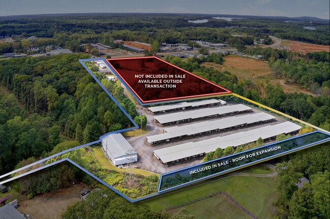
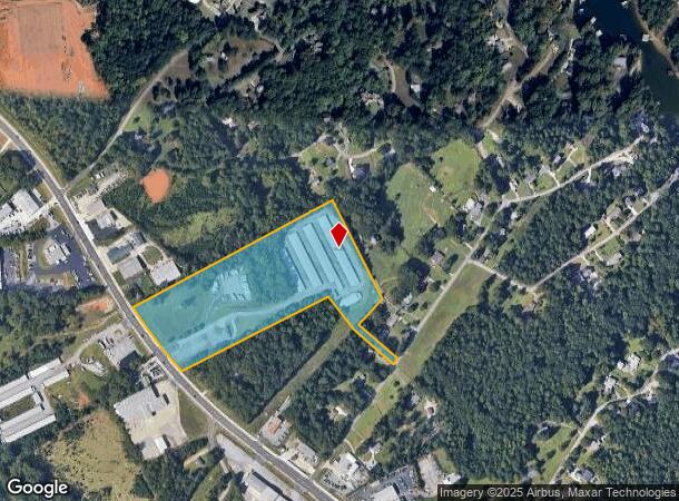


This Property Is For Sale
NEARBY LISTINGS FOR SALE OR LEASE
Property Detail
6005 Lanier Islands Pky
Gainesville, GA
Mm Beard
07-00330-06-009
6005 HOLIDAY ROAD
Officebuilding
Hall
X
Georgia
13139C0288G
329
2025
15.41 AC
2025
Gainesville/Hall County
001502
Atlanta
1,716 SF
DEMOGRAPHICS near 6005 Lanier Islands Pky
1 Mile
3 Mile
5 Mile
2024 Total Population
1,549
23,696
78,122
2029 Population
1,710
25,635
84,288
Pop Growth 2024-2029
+ 10.39%
+ 8.18%
+ 7.89%
Average Age
46
39
38
2024 Total Households
614
8,129
26,514
HH Growth 2024-2029
+ 10.26%
+ 8.35%
+ 8.11%
Median Household Inc
$72,284
$79,173
$82,465
Avg Household Size
2.50
2.90
2.90
2024 Avg HH Vehicles
2.00
2.00
2.00
Median Home Value
$413,934
$337,528
$324,995
Median Year Built
1993
1997
2001
Nearby Places
Map Layers
Map Styles
 Street
 Aerial
- Restaurants
- Banks
- Shops
- Fitness
- Groceries
Nearby Properties
Address
Land Use
TOTAL SIZE
Lot Size
Zoning
Address
Land Use
TOTAL SIZE
Lot Size
Zoning
285,000 SF
97.06 AC
M-I
Address
Land Use
TOTAL SIZE
Lot Size
Zoning
815,563 SF
58.80 AC
M-I
Address
Land Use
TOTAL SIZE
Lot Size
Zoning
101,632 SF
78.33 AC
M-I
Address
Land Use
TOTAL SIZE
Lot Size
Zoning
286,520 SF
21.60 AC
P
Address
Land Use
TOTAL SIZE
Lot Size
Zoning
213,532 SF
44.32 AC
M-I
Address
Land Use
TOTAL SIZE
Lot Size
Zoning
224,093 SF
33.94 AC
M-I
Address
Land Use
TOTAL SIZE
Lot Size
Zoning
652,710 SF
40.90 AC
M1
Address
Land Use
TOTAL SIZE
Lot Size
Zoning
264,600 SF
10.27 AC
M1
Address
Land Use
TOTAL SIZE
Lot Size
Zoning
150,591 SF
24.39 AC
P
Address
Land Use
TOTAL SIZE
Lot Size
Zoning
641,180 SF
57.04 AC
M1
Address
Land Use
TOTAL SIZE
Lot Size
Zoning
875,180 SF
58.69 AC
C1
Address
Land Use
TOTAL SIZE
Lot Size
Zoning
573,750 SF
43.94 AC
C1
Address
Land Use
TOTAL SIZE
Lot Size
Zoning
143,000 SF
41.30 AC
M-I
Address
Land Use
TOTAL SIZE
Lot Size
Zoning
274,018 SF
25.57 AC
M1
Address
Land Use
TOTAL SIZE
Lot Size
Zoning
458,256 SF
26.39 AC
M-I
Address
Land Use
TOTAL SIZE
Lot Size
Zoning
261,368 SF
5.80 AC
M-I
Address
Land Use
TOTAL SIZE
Lot Size
Zoning
225,851 SF
34.35 AC
R75
Address
Land Use
TOTAL SIZE
Lot Size
Zoning
300,000 SF
23.03 AC
M-II
Address
Land Use
TOTAL SIZE
Lot Size
Zoning
350,084 SF
40 AC
M1
Address
Land Use
TOTAL SIZE
Lot Size
Zoning
151,330 SF
19.30 AC
RM
Address
Land Use
TOTAL SIZE
Lot Size
Zoning
139,430 SF
35.40 AC
P
Address
Land Use
TOTAL SIZE
Lot Size
Zoning
73,319 SF
17.43 AC
P
Address
Land Use
TOTAL SIZE
Lot Size
Zoning
303,526 SF
19.77 AC
M1
Address
Land Use
TOTAL SIZE
Lot Size
Zoning
158,900 SF
13.94 AC
M-II
Address
Land Use
TOTAL SIZE
Lot Size
Zoning
114,261 SF
93.99 AC
P
Address
Land Use
TOTAL SIZE
Lot Size
Zoning
250,444 SF
32.04 AC
M1
Address
Land Use
TOTAL SIZE
Lot Size
Zoning
130,211 SF
14.03 AC
C1
Address
Land Use
TOTAL SIZE
Lot Size
Zoning
53,504 SF
10.57 AC
P
Address
Land Use
TOTAL SIZE
Lot Size
Zoning
18,408 SF
15.50 AC
L-I
Address
Land Use
TOTAL SIZE
Lot Size
Zoning
236,184 SF
26.58 AC
M1
The World's #1 Commercial Real Estate Marketplace
Connect with us
© 2025 CoStar Group
The information above has been obtained from sources believed reliable. While we do not doubt its accuracy we have not verified it and make no guarantee, warranty or representation about it. It is your responsibility to independently confirm its accuracy and completeness. Any projections, opinions, assumptions, or estimates used are for example only and do not represent the current or future performance of the property. The value of this transaction to you depends on tax and other factors which should be evaluated by your tax, financial, and legal advisors. You and your advisors should conduct a careful, independent investigation of the property to determine to your satisfaction the suitability of the property for your needs.