Property Record
6005 N 72Nd St, Omaha, NE 68134

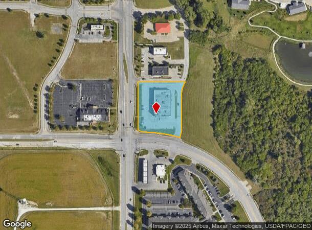
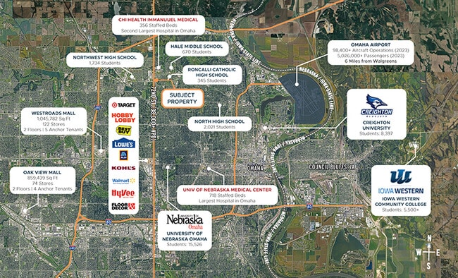

This Property Is For Sale
NEARBY LISTINGS FOR SALE OR LEASE
Property Detail
6005 N 72Nd St
Omaha-Council Bluffs, NE-IA
Shoppes At Crown Point The
3397-8020-22
SHOPPES AT CROWN POINT THE REP 1 LOT 1 BLOCK 0 IRREG 1.696 AC
Storebuilding
Douglas
X
Nebraska
31055C0209H
1
2024
1.70 AC
2025
Northeast Omaha
006506
Omaha/Council Bluffs
14,466 SF
DEMOGRAPHICS near 6005 N 72Nd St
1 Mile
3 Mile
5 Mile
2024 Total Population
10,759
88,132
214,049
2029 Population
10,921
89,324
217,714
Pop Growth 2024-2029
+ 1.51%
+ 1.35%
+ 1.71%
Average Age
40
37
37
2024 Total Households
3,986
34,452
87,249
HH Growth 2024-2029
+ 1.68%
+ 1.39%
+ 1.74%
Median Household Inc
$61,085
$56,751
$56,696
Avg Household Size
2.50
2.50
2.30
2024 Avg HH Vehicles
2.00
2.00
2.00
Median Home Value
$169,246
$163,333
$179,439
Median Year Built
1985
1965
1966
Nearby Places
Map Layers
Map Styles
 Street
 Aerial
- Restaurants
- Banks
- Shops
- Fitness
- Groceries
PUBLIC TRANSPORTATION
COMMUTER RAIL
Omaha Amtrak Station (California Zephyr - Amtrak)
DRIVE
WALK
Distance
Omaha Amtrak Station (California Zephyr - Amtrak)
16 min
9.3 mi
Omaha Amtrak Station (California Zephyr - Amtrak)
DRIVE
WALK
Distance
Omaha Amtrak Station (California Zephyr - Amtrak)
17 min
9.5 mi
AIRPORT
Eppley Airfield
DRIVE
WALK
Distance
Eppley Airfield
19 min
9.5 mi
Freight Ports
Tulsa Port Of Catoosa
DRIVE
WALK
Distance
Tulsa Port Of Catoosa
473 min
425.7 mi
Nearby Properties
Address
Land Use
TOTAL SIZE
Lot Size
Zoning
Address
Land Use
TOTAL SIZE
Lot Size
Zoning
548,510 SF
36.78 AC
Address
Land Use
TOTAL SIZE
Lot Size
Zoning
141,816 SF
24.91 AC
Address
Land Use
TOTAL SIZE
Lot Size
Zoning
251,394 SF
14.71 AC
Address
Land Use
TOTAL SIZE
Lot Size
Zoning
255,205 SF
9.41 AC
R6
Address
Land Use
TOTAL SIZE
Lot Size
Zoning
248,169 SF
10.39 AC
Address
Land Use
TOTAL SIZE
Lot Size
Zoning
125,945 SF
Address
Land Use
TOTAL SIZE
Lot Size
Zoning
216,823 SF
13.05 AC
Address
Land Use
TOTAL SIZE
Lot Size
Zoning
216,667 SF
8.13 AC
Address
Land Use
TOTAL SIZE
Lot Size
Zoning
186,710 SF
12.63 AC
R6
Address
Land Use
TOTAL SIZE
Lot Size
Zoning
149,539 SF
7.96 AC
R7
Address
Land Use
TOTAL SIZE
Lot Size
Zoning
228,860 SF
11.68 AC
Address
Land Use
TOTAL SIZE
Lot Size
Zoning
190,645 SF
17.99 AC
CC
Address
Land Use
TOTAL SIZE
Lot Size
Zoning
230,827 SF
15.11 AC
R6
Address
Land Use
TOTAL SIZE
Lot Size
Zoning
205,996 SF
23.01 AC
LI
Address
Land Use
TOTAL SIZE
Lot Size
Zoning
143,982 SF
6.93 AC
R6
Address
Land Use
TOTAL SIZE
Lot Size
Zoning
172,424 SF
2.88 AC
R7
Address
Land Use
TOTAL SIZE
Lot Size
Zoning
146,846 SF
8.67 AC
Address
Land Use
TOTAL SIZE
Lot Size
Zoning
109,605 SF
1.05 AC
Address
Land Use
TOTAL SIZE
Lot Size
Zoning
92,817 SF
5.68 AC
GO
Address
Land Use
TOTAL SIZE
Lot Size
Zoning
247,780 SF
12.15 AC
R6
Address
Land Use
TOTAL SIZE
Lot Size
Zoning
133,168 SF
2.09 AC
Address
Land Use
TOTAL SIZE
Lot Size
Zoning
120,839 SF
6.06 AC
Address
Land Use
TOTAL SIZE
Lot Size
Zoning
178,896 SF
16.92 AC
Address
Land Use
TOTAL SIZE
Lot Size
Zoning
80,668 SF
0.70 AC
GI
Address
Land Use
TOTAL SIZE
Lot Size
Zoning
178,314 SF
28.08 AC
Address
Land Use
TOTAL SIZE
Lot Size
Zoning
208,469 SF
12.53 AC
Address
Land Use
TOTAL SIZE
Lot Size
Zoning
126,372 SF
11.81 AC
Address
Land Use
TOTAL SIZE
Lot Size
Zoning
61,867 SF
8.46 AC
MU
Address
Land Use
TOTAL SIZE
Lot Size
Zoning
96,566 SF
5.01 AC
GI
Address
Land Use
TOTAL SIZE
Lot Size
Zoning
117,062 SF
7.09 AC
CC
The World's #1 Commercial Real Estate Marketplace
Connect with us
© 2025 CoStar Group
The information above has been obtained from sources believed reliable. While we do not doubt its accuracy we have not verified it and make no guarantee, warranty or representation about it. It is your responsibility to independently confirm its accuracy and completeness. Any projections, opinions, assumptions, or estimates used are for example only and do not represent the current or future performance of the property. The value of this transaction to you depends on tax and other factors which should be evaluated by your tax, financial, and legal advisors. You and your advisors should conduct a careful, independent investigation of the property to determine to your satisfaction the suitability of the property for your needs.