Property Record
6005 N Mcraven Rd, Jackson, MS 39209
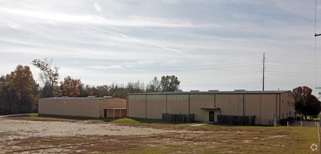

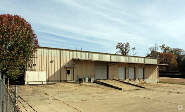
Property Detail
6005 N Mcraven Rd
0826-0040-000
BDG SE COR SEC 4 W 1337.79 FT TO POB W 300 FT N 303.88 FT E300 FT S 305.4 FT TO POB IN S 1/2 SEC 4 T5N R1W
Wholesaleoutletdiscountstore
Hinds
AE The base floodplain where base flood elevations are provided. AE Zones are now used on new format FIRMs instead of A1-A30 Zones.
Mississippi
0
2.09 AC
2025
Outlying Hinds County
010808
Jackson
23,600 SF
Jackson, MS
NEARBY LISTINGS FOR SALE OR LEASE
-
-
View all Jackson listings for lease on LoopNet.com
DEMOGRAPHICS near 6005 N Mcraven Rd
1 mile
3 mile
5 mile
2025 Total Population
436
20,271
73,476
2030 Population
412
18,992
70,471
Pop Growth 2025-2030
(5.50%)
(6.31%)
(4.09%)
Average Age
40
38
38
2025 Total Households
185
8,315
28,608
HH Growth 2025-2030
(5.95%)
(6.54%)
(4.35%)
Median Household Inc
$55,227
$55,384
$50,362
Avg Household Size
2.40
2.30
2.40
2025 Avg HH Vehicles
2.00
2.00
2.00
Median Home Value
$136,842
$160,099
$139,929
Median Year Built
1974
1978
1973
Nearby Places
Map Layers
Map Styles
 Street
 Aerial
Layers
 Traffic
 Biking
Places
Listings with unknown addresses are not visible on the map
- Restaurants
- Banks
- Shops
- Fitness
- Groceries
PUBLIC TRANSPORTATION
COMMUTER RAIL
Drive
Walk
Distance
14 min
6.9 mi
AIRPORT
Jackson-Medgar Wiley Evers International
Drive
Walk
Distance
Jackson-Medgar Wiley Evers International
28 min
17.7 mi
SALE & LEASE HISTORY
LISTING DATE
SALE/LEASE

Sep 25, 2016
For Lease
Nearby Properties
Address
Land Use
TOTAL SIZE
Lot Size
Zoning
Address
Land Use
TOTAL SIZE
Lot Size
Zoning
113,434 SF
82.60 AC
Address
Land Use
TOTAL SIZE
Lot Size
Zoning
192,048 SF
23.70 AC
Address
Land Use
TOTAL SIZE
Lot Size
Zoning
41,110 SF
4.48 AC
Address
Land Use
TOTAL SIZE
Lot Size
Zoning
314,964 SF
26.02 AC
Address
Land Use
TOTAL SIZE
Lot Size
Zoning
41,616 SF
176,418.04 AC
Address
Land Use
TOTAL SIZE
Lot Size
Zoning
37,293 SF
10 AC
Address
Land Use
TOTAL SIZE
Lot Size
Zoning
32,617 SF
348,480.26 AC
Address
Land Use
TOTAL SIZE
Lot Size
Zoning
40.55 AC
Address
Land Use
TOTAL SIZE
Lot Size
Zoning
199,954 SF
23 AC
Address
Land Use
TOTAL SIZE
Lot Size
Zoning
188,317 SF
23 AC
Address
Land Use
TOTAL SIZE
Lot Size
Zoning
90,036 SF
79.05 AC
Address
Land Use
TOTAL SIZE
Lot Size
Zoning
171,950 SF
9 AC
Address
Land Use
TOTAL SIZE
Lot Size
Zoning
66,132 SF
8.91 AC
Address
Land Use
TOTAL SIZE
Lot Size
Zoning
138,086 SF
14 AC
Address
Land Use
TOTAL SIZE
Lot Size
Zoning
223,892 SF
15 AC
Address
Land Use
TOTAL SIZE
Lot Size
Zoning
148,263 SF
11.26 AC
Address
Land Use
TOTAL SIZE
Lot Size
Zoning
16,070 SF
6 AC
Address
Land Use
TOTAL SIZE
Lot Size
Zoning
11,950 SF
2 AC
Address
Land Use
TOTAL SIZE
Lot Size
Zoning
11,256 SF
3.60 AC
Address
Land Use
TOTAL SIZE
Lot Size
Zoning
107,193 SF
10 AC
Address
Land Use
TOTAL SIZE
Lot Size
Zoning
7.28 AC
Address
Land Use
TOTAL SIZE
Lot Size
Zoning
13,721 SF
1.80 AC
Address
Land Use
TOTAL SIZE
Lot Size
Zoning
20,902 SF
2 AC
Address
Land Use
TOTAL SIZE
Lot Size
Zoning
15.26 AC
Address
Land Use
TOTAL SIZE
Lot Size
Zoning
21.12 AC
Address
Land Use
TOTAL SIZE
Lot Size
Zoning
126,024 SF
8.20 AC
Address
Land Use
TOTAL SIZE
Lot Size
Zoning
185,868 SF
12 AC
Address
Land Use
TOTAL SIZE
Lot Size
Zoning
96,372 SF
9.19 AC
Address
Land Use
TOTAL SIZE
Lot Size
Zoning
22,053 SF
43 AC
Address
Land Use
TOTAL SIZE
Lot Size
Zoning
11,354 SF
50.54 AC
The World's #1 Commercial Real Estate Marketplace
Connect with us
© 2026 CoStar Group
The information above has been obtained from sources believed reliable. While we do not doubt its accuracy we have not verified it and make no guarantee, warranty or representation about it. It is your responsibility to independently confirm its accuracy and completeness. Any projections, opinions, assumptions, or estimates used are for example only and do not represent the current or future performance of the property. The value of this transaction to you depends on tax and other factors which should be evaluated by your tax, financial, and legal advisors. You and your advisors should conduct a careful, independent investigation of the property to determine to your satisfaction the suitability of the property for your needs.