Property Record
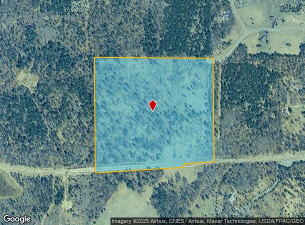
6005 Oakdale Rd, Baxter, MN 56425
NEARBY LISTINGS FOR SALE OR LEASE
Property Detail
6005 Oakdale Rd
020243100000009
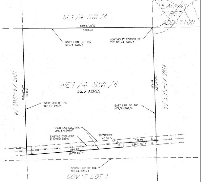
THAT PART OF THE NE1/4 OF SW1/4, WHICH LIES N'LY OF THE FOLLOWING DESC LINE; COMM AT THE NE CORNER OF SAID NESW, THEN S 00 DE
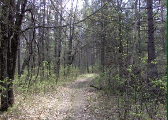
Forest
Crow Wing
X
Minnesota
27097C0100E
35.29 AC
2025
Minnesota Central Area
2025
Other Market Areas
951304
Brainerd, MN
672 SF
DEMOGRAPHICS near 6005 Oakdale Rd
1 Mile
3 Mile
5 Mile
2024 Total Population
283
6,289
18,396
2029 Population
292
6,553
19,206
Pop Growth 2024-2029
+ 3.18%
+ 4.20%
+ 4.40%
Average Age
37
40
40
2024 Total Households
112
2,397
7,403
HH Growth 2024-2029
+ 2.68%
+ 3.88%
+ 4.07%
Median Household Inc
$63,125
$80,343
$59,886
Avg Household Size
2.50
2.50
2.30
2024 Avg HH Vehicles
2.00
2.00
2.00
Median Home Value
$274,999
$241,896
$202,066
Median Year Built
1993
1993
1987
Nearby Places
Map Layers
Map Styles
 Street
 Aerial
- Restaurants
- Banks
- Shops
- Fitness
- Groceries
Nearby Properties
Address
Land Use
TOTAL SIZE
Lot Size
Zoning
Address
Land Use
TOTAL SIZE
Lot Size
Zoning
344,274 SF
163.56 AC
Address
Land Use
TOTAL SIZE
Lot Size
Zoning
33,460 SF
94.30 AC
Address
Land Use
TOTAL SIZE
Lot Size
Zoning
63,251 SF
8.27 AC
Address
Land Use
TOTAL SIZE
Lot Size
Zoning
50,741 SF
13.48 AC
Address
Land Use
TOTAL SIZE
Lot Size
Zoning
55,953 SF
14.52 AC
Address
Land Use
TOTAL SIZE
Lot Size
Zoning
68,675 SF
3.12 AC
Address
Land Use
TOTAL SIZE
Lot Size
Zoning
68,675 SF
3.06 AC
Address
Land Use
TOTAL SIZE
Lot Size
Zoning
209,815 SF
22.30 AC
Address
Land Use
TOTAL SIZE
Lot Size
Zoning
79,048 SF
5.33 AC
Address
Land Use
TOTAL SIZE
Lot Size
Zoning
38,487 SF
2.78 AC
Address
Land Use
TOTAL SIZE
Lot Size
Zoning
89,709 SF
8.69 AC
Address
Land Use
TOTAL SIZE
Lot Size
Zoning
21,876 SF
9.73 AC
Address
Land Use
TOTAL SIZE
Lot Size
Zoning
64,719 SF
2.06 AC
Address
Land Use
TOTAL SIZE
Lot Size
Zoning
64,719 SF
2.19 AC
Address
Land Use
TOTAL SIZE
Lot Size
Zoning
49,991 SF
9.59 AC
Address
Land Use
TOTAL SIZE
Lot Size
Zoning
17,516 SF
3.46 AC
Address
Land Use
TOTAL SIZE
Lot Size
Zoning
91,681 SF
6.65 AC
Address
Land Use
TOTAL SIZE
Lot Size
Zoning
125,156 SF
13.35 AC
Address
Land Use
TOTAL SIZE
Lot Size
Zoning
19,348 SF
5.64 AC
Address
Land Use
TOTAL SIZE
Lot Size
Zoning
40,728 SF
3.09 AC
Address
Land Use
TOTAL SIZE
Lot Size
Zoning
15,276 SF
2.98 AC
Address
Land Use
TOTAL SIZE
Lot Size
Zoning
83,605 SF
7.21 AC
Address
Land Use
TOTAL SIZE
Lot Size
Zoning
9,511 SF
3.78 AC
Address
Land Use
TOTAL SIZE
Lot Size
Zoning
15,634 SF
3.26 AC
Address
Land Use
TOTAL SIZE
Lot Size
Zoning
20,290 SF
5.92 AC
Address
Land Use
TOTAL SIZE
Lot Size
Zoning
1,250,000 SF
2.44 AC
Address
Land Use
TOTAL SIZE
Lot Size
Zoning
27,166 SF
2.10 AC
Address
Land Use
TOTAL SIZE
Lot Size
Zoning
25,899 SF
1.86 AC
Address
Land Use
TOTAL SIZE
Lot Size
Zoning
21,531 SF
2.33 AC
The World's #1 Commercial Real Estate Marketplace
Connect with us
© 2025 CoStar Group
The information above has been obtained from sources believed reliable. While we do not doubt its accuracy we have not verified it and make no guarantee, warranty or representation about it. It is your responsibility to independently confirm its accuracy and completeness. Any projections, opinions, assumptions, or estimates used are for example only and do not represent the current or future performance of the property. The value of this transaction to you depends on tax and other factors which should be evaluated by your tax, financial, and legal advisors. You and your advisors should conduct a careful, independent investigation of the property to determine to your satisfaction the suitability of the property for your needs.