Property Record
6005 W Ryan Rd, Franklin, WI 53132
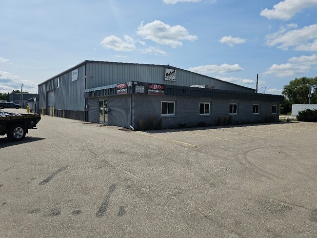


Property Detail
6005 W Ryan Rd
Milwaukee-Waukesha, WI
CERTIFIED SURVEY MAP NO 4929 NE 27 5 21 PARCEL 1
898-9997-017
MILWAUKEE
Commercialnec
Wisconsin
B and X Area of moderate flood hazard, usually the area between the limits of the 100-year and 500-year floods.
1
2024
2.76 AC
2024
SW Outlying Milwaukee
187200
Milwaukee/Madison
15,226 SF
NEARBY LISTINGS FOR SALE OR LEASE
DEMOGRAPHICS near 6005 W Ryan Rd
1 mile
3 mile
5 mile
2025 Total Population
1,029
24,557
81,250
2030 Population
1,025
24,487
81,424
Pop Growth 2025-2030
(0.39%)
(0.29%)
+ 0.21%
Average Age
41
43
42
2025 Total Households
377
9,860
33,119
HH Growth 2025-2030
(0.53%)
(0.40%)
+ 0.17%
Median Household Inc
$171,304
$113,611
$99,451
Avg Household Size
2.70
2.50
2.40
2025 Avg HH Vehicles
2.00
2.00
2.00
Median Home Value
$423,077
$370,949
$345,764
Median Year Built
1999
1991
1986
Nearby Places
Map Layers
Map Styles
 Street
 Aerial
Layers
 Traffic
 Biking
Places
Listings with unknown addresses are not visible on the map
- Restaurants
- Banks
- Shops
- Fitness
- Groceries
PUBLIC TRANSPORTATION
COMMUTER RAIL
General Mitchell Intl. Airport Amtrak Station (Hiawatha Service - Amtrak)
Drive
Walk
Distance
General Mitchell Intl. Airport Amtrak Station (Hiawatha Service - Amtrak)
16 min
8.7 mi
AIRPORT
General Mitchell International
Drive
Walk
Distance
General Mitchell International
16 min
9.6 mi
Freight Ports
Port Milwaukee
Drive
Walk
Distance
Port Milwaukee
20 min
13.5 mi
SALE & LEASE HISTORY
LISTING DATE
SALE/LEASE

Oct 01, 2024
For Lease
Nearby Properties
Address
Land Use
TOTAL SIZE
Lot Size
Zoning
Address
Land Use
TOTAL SIZE
Lot Size
Zoning
47.22 AC
RESIDENTIA
Address
Land Use
TOTAL SIZE
Lot Size
Zoning
16.06 AC
Address
Land Use
TOTAL SIZE
Lot Size
Zoning
8.79 AC
RESIDENTIA
Address
Land Use
TOTAL SIZE
Lot Size
Zoning
18.39 AC
RESIDENTIA
Address
Land Use
TOTAL SIZE
Lot Size
Zoning
64,800 SF
28.17 AC
Address
Land Use
TOTAL SIZE
Lot Size
Zoning
33.48 AC
Address
Land Use
TOTAL SIZE
Lot Size
Zoning
17.37 AC
Address
Land Use
TOTAL SIZE
Lot Size
Zoning
16.48 AC
Address
Land Use
TOTAL SIZE
Lot Size
Zoning
14.24 AC
RESIDENTIA
Address
Land Use
TOTAL SIZE
Lot Size
Zoning
19.25 AC
Address
Land Use
TOTAL SIZE
Lot Size
Zoning
26.03 AC
Address
Land Use
TOTAL SIZE
Lot Size
Zoning
17.95 AC
RESIDENTIA
Address
Land Use
TOTAL SIZE
Lot Size
Zoning
42,253 SF
6.93 AC
Address
Land Use
TOTAL SIZE
Lot Size
Zoning
57,474 SF
5.07 AC
Address
Land Use
TOTAL SIZE
Lot Size
Zoning
21.21 AC
Address
Land Use
TOTAL SIZE
Lot Size
Zoning
12.45 AC
Address
Land Use
TOTAL SIZE
Lot Size
Zoning
Address
Land Use
TOTAL SIZE
Lot Size
Zoning
Address
Land Use
TOTAL SIZE
Lot Size
Zoning
Address
Land Use
TOTAL SIZE
Lot Size
Zoning
12.31 AC
Address
Land Use
TOTAL SIZE
Lot Size
Zoning
13.16 AC
Address
Land Use
TOTAL SIZE
Lot Size
Zoning
131,004 SF
6.88 AC
Address
Land Use
TOTAL SIZE
Lot Size
Zoning
129,024 SF
7.61 AC
Address
Land Use
TOTAL SIZE
Lot Size
Zoning
6.93 AC
Address
Land Use
TOTAL SIZE
Lot Size
Zoning
34.39 AC
Address
Land Use
TOTAL SIZE
Lot Size
Zoning
9.30 AC
Address
Land Use
TOTAL SIZE
Lot Size
Zoning
3.80 AC
RESIDENTIA
Address
Land Use
TOTAL SIZE
Lot Size
Zoning
9.09 AC
Address
Land Use
TOTAL SIZE
Lot Size
Zoning
26.40 AC
Address
Land Use
TOTAL SIZE
Lot Size
Zoning
2,912 SF
0.16 AC
The World's #1 Commercial Real Estate Marketplace
Connect with us
© 2026 CoStar Group
The information above has been obtained from sources believed reliable. While we do not doubt its accuracy we have not verified it and make no guarantee, warranty or representation about it. It is your responsibility to independently confirm its accuracy and completeness. Any projections, opinions, assumptions, or estimates used are for example only and do not represent the current or future performance of the property. The value of this transaction to you depends on tax and other factors which should be evaluated by your tax, financial, and legal advisors. You and your advisors should conduct a careful, independent investigation of the property to determine to your satisfaction the suitability of the property for your needs.