Property Record
6009 121St Ave N, Parrish, FL 34219


Property Detail
6009 121St Ave N
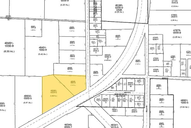
4828-0000-0
ALL THAT PART OF N 1/2 OF SE 1/4 OF NW 1/4 LY WLY OF W R/W OF TAMPA RD, & NLY OF PRESENT R/W OF U S H/W 301 DESC ORB 189 P 234, PRMCF P-28;LESS OR 2739/2628 DESC AS FOLLOWS: A
Servicestationmarket
Manatee
PD-C
Florida
AE The base floodplain where base flood elevations are provided. AE Zones are now used on new format FIRMs instead of A1-A30 Zones.
2.37 AC
2023
Manatee
2025
Tampa/St Petersburg
001913
North Port-Bradenton-Sarasota, FL
10,560 SF
NEARBY LISTINGS FOR SALE OR LEASE
DEMOGRAPHICS near 6009 121St Ave N
1 mile
3 mile
5 mile
2025 Total Population
4,012
32,745
72,768
2030 Population
4,495
38,013
84,027
Pop Growth 2025-2030
+ 12.04%
+ 16.09%
+ 15.47%
Average Age
42
43
46
2025 Total Households
1,449
11,731
27,871
HH Growth 2025-2030
+ 12.15%
+ 15.51%
+ 15.02%
Median Household Inc
$100,152
$110,499
$104,677
Avg Household Size
2.70
2.70
2.50
2025 Avg HH Vehicles
2.00
2.00
2.00
Median Home Value
$417,014
$453,442
$454,960
Median Year Built
2010
2010
2010
Nearby Places
Map Layers
Map Styles
 Street
 Aerial
Layers
 Traffic
 Biking
Places
Listings with unknown addresses are not visible on the map
- Restaurants
- Banks
- Shops
- Fitness
- Groceries
PUBLIC TRANSPORTATION
AIRPORT
Sarasota/Bradenton International
Drive
Walk
Distance
Sarasota/Bradenton International
35 min
19.2 mi
St Pete-Clearwater International
Drive
Walk
Distance
St Pete-Clearwater International
59 min
41.1 mi
Tampa International
Drive
Walk
Distance
Tampa International
64 min
43.8 mi
Freight Ports
Port Manatee
Drive
Walk
Distance
Port Manatee
22 min
12.3 mi
SALE & LEASE HISTORY
LISTING DATE
SALE/LEASE

Sep 01, 2017
For Sale
Nearby Properties
Address
Land Use
TOTAL SIZE
Lot Size
Zoning
Address
Land Use
TOTAL SIZE
Lot Size
Zoning
137.34 AC
Address
Land Use
TOTAL SIZE
Lot Size
Zoning
136.89 AC
Address
Land Use
TOTAL SIZE
Lot Size
Zoning
50.25 AC
Address
Land Use
TOTAL SIZE
Lot Size
Zoning
64,800 SF
8.19 AC
Address
Land Use
TOTAL SIZE
Lot Size
Zoning
66,063 SF
9.24 AC
PD-C
Address
Land Use
TOTAL SIZE
Lot Size
Zoning
43,464 SF
14.47 AC
VIL VILLAG
Address
Land Use
TOTAL SIZE
Lot Size
Zoning
43.81 AC
Address
Land Use
TOTAL SIZE
Lot Size
Zoning
50,580 SF
5.97 AC
Address
Land Use
TOTAL SIZE
Lot Size
Zoning
53,851 SF
6.32 AC
Address
Land Use
TOTAL SIZE
Lot Size
Zoning
30,101 SF
13.44 AC
PD-C
Address
Land Use
TOTAL SIZE
Lot Size
Zoning
76.98 AC
Address
Land Use
TOTAL SIZE
Lot Size
Zoning
36,700 SF
17 AC
A-1 SUBURB
Address
Land Use
TOTAL SIZE
Lot Size
Zoning
109.06 AC
Address
Land Use
TOTAL SIZE
Lot Size
Zoning
3.11 AC
Address
Land Use
TOTAL SIZE
Lot Size
Zoning
4.07 AC
Address
Land Use
TOTAL SIZE
Lot Size
Zoning
53,448 SF
3 AC
PD-C
Address
Land Use
TOTAL SIZE
Lot Size
Zoning
44.29 AC
Address
Land Use
TOTAL SIZE
Lot Size
Zoning
25,842 SF
3.92 AC
Address
Land Use
TOTAL SIZE
Lot Size
Zoning
9,806 SF
4.04 AC
VIL VILLAG
Address
Land Use
TOTAL SIZE
Lot Size
Zoning
17,677 SF
9.52 AC
A-1 SUBURB
Address
Land Use
TOTAL SIZE
Lot Size
Zoning
113.80 AC
Address
Land Use
TOTAL SIZE
Lot Size
Zoning
13.62 AC
PD-R
Address
Land Use
TOTAL SIZE
Lot Size
Zoning
7.54 AC
Address
Land Use
TOTAL SIZE
Lot Size
Zoning
293,048 SF
42.24 AC
A-1 SUBURB
Address
Land Use
TOTAL SIZE
Lot Size
Zoning
10,303 SF
1.26 AC
PD-MU
Address
Land Use
TOTAL SIZE
Lot Size
Zoning
0.15 AC
PDR
Address
Land Use
TOTAL SIZE
Lot Size
Zoning
1,412 SF
2.16 AC
PD-R
Address
Land Use
TOTAL SIZE
Lot Size
Zoning
34,824 SF
192.28 AC
PD-R
Address
Land Use
TOTAL SIZE
Lot Size
Zoning
1.96 AC
Address
Land Use
TOTAL SIZE
Lot Size
Zoning
50.40 AC
PD-MU
The World's #1 Commercial Real Estate Marketplace
Connect with us
© 2026 CoStar Group
The information above has been obtained from sources believed reliable. While we do not doubt its accuracy we have not verified it and make no guarantee, warranty or representation about it. It is your responsibility to independently confirm its accuracy and completeness. Any projections, opinions, assumptions, or estimates used are for example only and do not represent the current or future performance of the property. The value of this transaction to you depends on tax and other factors which should be evaluated by your tax, financial, and legal advisors. You and your advisors should conduct a careful, independent investigation of the property to determine to your satisfaction the suitability of the property for your needs.