Property Record
601 E Red Bud Ave, Saint Louis, MO 63147


Save to a Folder
{{folder.Name}}
{{folder.ListingIds.length}} Properties
{{folder.ListingIds.length}} Property
Create a New Folder
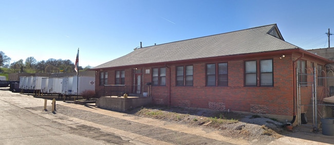
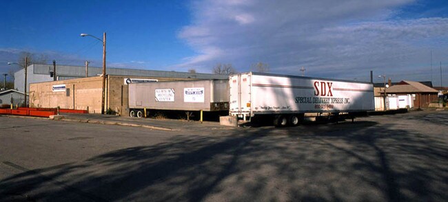
Property Detail
601 E Red Bud Ave
St. Louis, MO-IL
C B 3433 RED BUD 530 FT X 147 FT 9 IN 1.80 ACRES 0FALLONS ADDN LOTS 1 TO 21 INC
3433-00-0050-0
Saint Louis City
Warehouse
Missouri
J
1-21
2025
1.80 AC
2026
St Louis City North
109600
St. Louis
61,118 SF
NEARBY LISTINGS FOR SALE OR LEASE
DEMOGRAPHICS near 601 E Red Bud Ave
1 mile
3 mile
5 mile
2025 Total Population
4,965
62,767
213,583
2030 Population
5,061
63,050
212,827
Pop Growth 2025-2030
+ 1.93%
+ 0.45%
(0.35%)
Average Age
43
42
40
2025 Total Households
2,108
26,492
96,049
HH Growth 2025-2030
+ 1.66%
+ 0.15%
(1.01%)
Median Household Inc
$34,465
$35,412
$44,638
Avg Household Size
2.20
2.20
2.10
2025 Avg HH Vehicles
1.00
1.00
1.00
Median Home Value
$71,526
$70,816
$89,768
Median Year Built
1946
1947
1949
Nearby Places
Map Layers
Map Styles
 Street
 Aerial
Layers
 Traffic
 Biking
Places
Listings with unknown addresses are not visible on the map
- Restaurants
- Banks
- Shops
- Fitness
- Groceries
SALE & LEASE HISTORY
LISTING DATE
SALE/LEASE

Sep 19, 2024
For Sale
Sep 06, 2017
For Sale
Oct 11, 2023
For Lease
Mar 04, 2019
For Sale
Nearby Properties
Address
Land Use
TOTAL SIZE
Lot Size
Zoning
Address
Land Use
TOTAL SIZE
Lot Size
Zoning
Address
Land Use
TOTAL SIZE
Lot Size
Zoning
124.96 AC
J
Address
Land Use
TOTAL SIZE
Lot Size
Zoning
472,328 SF
19.85 AC
I
Address
Land Use
TOTAL SIZE
Lot Size
Zoning
Address
Land Use
TOTAL SIZE
Lot Size
Zoning
98,308 SF
97.62 AC
H
Address
Land Use
TOTAL SIZE
Lot Size
Zoning
Address
Land Use
TOTAL SIZE
Lot Size
Zoning
54.74 AC
K
Address
Land Use
TOTAL SIZE
Lot Size
Zoning
46.18 AC
A
Address
Land Use
TOTAL SIZE
Lot Size
Zoning
298,990 SF
6.62 AC
I
Address
Land Use
TOTAL SIZE
Lot Size
Zoning
51,460 SF
101.96 AC
K
Address
Land Use
TOTAL SIZE
Lot Size
Zoning
229.57 AC
A
Address
Land Use
TOTAL SIZE
Lot Size
Zoning
Address
Land Use
TOTAL SIZE
Lot Size
Zoning
353,312 SF
17.84 AC
K
Address
Land Use
TOTAL SIZE
Lot Size
Zoning
429,181 SF
23.56 AC
K
Address
Land Use
TOTAL SIZE
Lot Size
Zoning
86,000 SF
2.07 AC
D
Address
Land Use
TOTAL SIZE
Lot Size
Zoning
471,077 SF
16.09 AC
K
Address
Land Use
TOTAL SIZE
Lot Size
Zoning
107,814 SF
5.89 AC
K
Address
Land Use
TOTAL SIZE
Lot Size
Zoning
130.85 AC
B
Address
Land Use
TOTAL SIZE
Lot Size
Zoning
297,169 SF
18.01 AC
K
Address
Land Use
TOTAL SIZE
Lot Size
Zoning
127.48 AC
B
Address
Land Use
TOTAL SIZE
Lot Size
Zoning
24,392 SF
2.26 AC
F
Address
Land Use
TOTAL SIZE
Lot Size
Zoning
118,410 SF
2.25 AC
D
Address
Land Use
TOTAL SIZE
Lot Size
Zoning
11,126 SF
7.21 AC
J
Address
Land Use
TOTAL SIZE
Lot Size
Zoning
45,106 SF
8.07 AC
G
Address
Land Use
TOTAL SIZE
Lot Size
Zoning
18,607 SF
0.61 AC
C
Address
Land Use
TOTAL SIZE
Lot Size
Zoning
46,710 SF
4.53 AC
G
Address
Land Use
TOTAL SIZE
Lot Size
Zoning
76,200 SF
4.85 AC
A
Address
Land Use
TOTAL SIZE
Lot Size
Zoning
7.76 AC
CH
Address
Land Use
TOTAL SIZE
Lot Size
Zoning
87,419 SF
3.72 AC
D
Address
Land Use
TOTAL SIZE
Lot Size
Zoning
88,800 SF
1.20 AC
A
The World's #1 Commercial Real Estate Marketplace
Connect with us
© 2026 CoStar Group
The information above has been obtained from sources believed reliable. While we do not doubt its accuracy we have not verified it and make no guarantee, warranty or representation about it. It is your responsibility to independently confirm its accuracy and completeness. Any projections, opinions, assumptions, or estimates used are for example only and do not represent the current or future performance of the property. The value of this transaction to you depends on tax and other factors which should be evaluated by your tax, financial, and legal advisors. You and your advisors should conduct a careful, independent investigation of the property to determine to your satisfaction the suitability of the property for your needs.