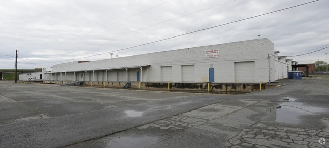
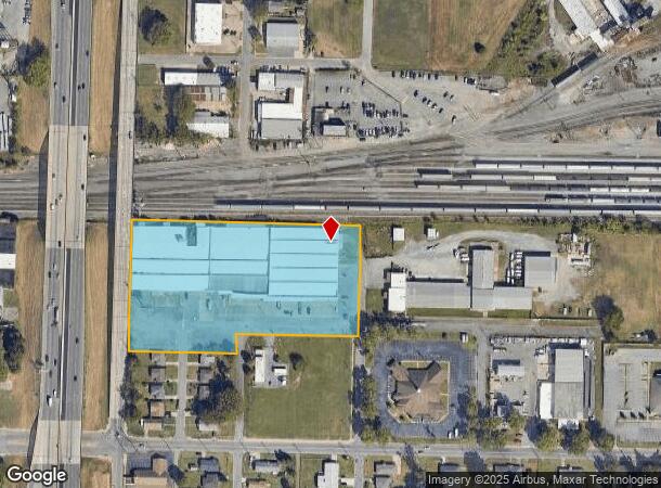
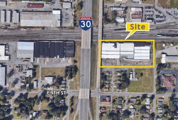
Property Record
1003 Vine St, North Little Rock, AR 72114
Current Lease Availabilities
NEARBY LISTINGS FOR SALE OR LEASE
Property Detail
1003 Vine St
Little Rock-North Little Rock-Conway, AR
Iron Mountain
33N-286-00-064-00
PT BLK 15 AND ALL BLKS 17 AND 18 IRON MTN ADDN AND LTS 1 AND 12 CAMPUS SUB AND PORTIONS OF DAVIS ST PINE ST AND 10TH ST NOW CLOSED MPDA BEG AT INERS E R/W I-30 AND S R/W UP RR TH E651.20' TO W R/W VINE ST TH S0*23'W362.85' N89*40'W330' TO CLN PINE ST
Industrialgeneral
Pulaski
AH
Arkansas
05119C0344G
1,12
2025
5.58 AC
2025
North Little Rock
002800
Little Rock/N Little Rock
119,552 SF
DEMOGRAPHICS near 1003 Vine St
1 Mile
3 Mile
5 Mile
2024 Total Population
5,201
54,717
118,861
2029 Population
5,438
55,659
120,100
Pop Growth 2024-2029
+ 4.56%
+ 1.72%
+ 1.04%
Average Age
39
39
40
2024 Total Households
2,647
26,472
54,219
HH Growth 2024-2029
+ 4.46%
+ 1.67%
+ 1.06%
Median Household Inc
$30,771
$42,577
$46,363
Avg Household Size
1.90
2.00
2.10
2024 Avg HH Vehicles
1.00
1.00
2.00
Median Home Value
$82,758
$152,074
$156,503
Median Year Built
1978
1966
1968
Nearby Places
Map Layers
Map Styles
 Street
 Aerial
- Restaurants
- Banks
- Shops
- Fitness
- Groceries
PUBLIC TRANSPORTATION
TRANSIT/SUBWAY
Main St & Bishop Lindsey Ave (Blue Line Streetcar - Rock Region Metro)
DRIVE
WALK
Distance
Main St & Bishop Lindsey Ave (Blue Line Streetcar - Rock Region Metro)
2 min
14 min
0.7 mi
Maple St & 6Th St (Blue Line Streetcar - Rock Region Metro)
DRIVE
WALK
Distance
Maple St & 6Th St (Blue Line Streetcar - Rock Region Metro)
2 min
16 min
0.8 mi
Main St & 5Th St (Blue Line Streetcar - Rock Region Metro)
DRIVE
WALK
Distance
Main St & 5Th St (Blue Line Streetcar - Rock Region Metro)
2 min
16 min
0.9 mi
Maple St & Broadway St (Blue Line Streetcar - Rock Region Metro)
DRIVE
WALK
Distance
Maple St & Broadway St (Blue Line Streetcar - Rock Region Metro)
2 min
19 min
1.0 mi
Simmons Arena (To Lr) (Blue Line Streetcar - Rock Region Metro)
DRIVE
WALK
Distance
Simmons Arena (To Lr) (Blue Line Streetcar - Rock Region Metro)
2 min
20 min
1.0 mi
COMMUTER RAIL
Little Rock Union Station (Texas Eagle - Amtrak)
DRIVE
WALK
Distance
Little Rock Union Station (Texas Eagle - Amtrak)
5 min
2.5 mi
AIRPORT
Bill and Hillary Clinton Ntl/Adams Field
DRIVE
WALK
Distance
Bill and Hillary Clinton Ntl/Adams Field
11 min
6.1 mi
Freight Ports
Port of Shreveport
DRIVE
WALK
Distance
Port of Shreveport
252 min
235.0 mi
Nearby Properties
Address
Land Use
TOTAL SIZE
Lot Size
Zoning
Address
Land Use
TOTAL SIZE
Lot Size
Zoning
1.80 AC
Address
Land Use
TOTAL SIZE
Lot Size
Zoning
0.90 AC
Address
Land Use
TOTAL SIZE
Lot Size
Zoning
0.45 AC
Address
Land Use
TOTAL SIZE
Lot Size
Zoning
1,000,000 SF
9.38 AC
Address
Land Use
TOTAL SIZE
Lot Size
Zoning
333,096 SF
11.62 AC
Address
Land Use
TOTAL SIZE
Lot Size
Zoning
237,144 SF
1.26 AC
Address
Land Use
TOTAL SIZE
Lot Size
Zoning
526,829 SF
33.78 AC
Address
Land Use
TOTAL SIZE
Lot Size
Zoning
180,616 SF
0.91 AC
Address
Land Use
TOTAL SIZE
Lot Size
Zoning
12,562 SF
2.26 AC
Address
Land Use
TOTAL SIZE
Lot Size
Zoning
412,597 SF
Address
Land Use
TOTAL SIZE
Lot Size
Zoning
379,202 SF
118.65 AC
Address
Land Use
TOTAL SIZE
Lot Size
Zoning
297,814 SF
86.09 AC
Address
Land Use
TOTAL SIZE
Lot Size
Zoning
22,017 SF
2.06 AC
Address
Land Use
TOTAL SIZE
Lot Size
Zoning
305,882 SF
7.82 AC
Address
Land Use
TOTAL SIZE
Lot Size
Zoning
761,810 SF
75.61 AC
Address
Land Use
TOTAL SIZE
Lot Size
Zoning
2,636 SF
0.67 AC
Address
Land Use
TOTAL SIZE
Lot Size
Zoning
267,152 SF
Address
Land Use
TOTAL SIZE
Lot Size
Zoning
137,538 SF
31.58 AC
Address
Land Use
TOTAL SIZE
Lot Size
Zoning
260,000 SF
5.80 AC
Address
Land Use
TOTAL SIZE
Lot Size
Zoning
143,553 SF
12.76 AC
Address
Land Use
TOTAL SIZE
Lot Size
Zoning
130,742 SF
15.71 AC
Address
Land Use
TOTAL SIZE
Lot Size
Zoning
95,719 SF
32.76 AC
Address
Land Use
TOTAL SIZE
Lot Size
Zoning
346,974 SF
Address
Land Use
TOTAL SIZE
Lot Size
Zoning
138,352 SF
2.95 AC
Address
Land Use
TOTAL SIZE
Lot Size
Zoning
61,225 SF
5.66 AC
Address
Land Use
TOTAL SIZE
Lot Size
Zoning
269,624 SF
3.40 AC
Address
Land Use
TOTAL SIZE
Lot Size
Zoning
361,910 SF
Address
Land Use
TOTAL SIZE
Lot Size
Zoning
41,925 SF
13 AC
Address
Land Use
TOTAL SIZE
Lot Size
Zoning
83,652 SF
12.55 AC
Address
Land Use
TOTAL SIZE
Lot Size
Zoning
36,711 SF
28.35 AC
The World's #1 Commercial Real Estate Marketplace
Connect with us
© 2026 CoStar Group
The information above has been obtained from sources believed reliable. While we do not doubt its accuracy we have not verified it and make no guarantee, warranty or representation about it. It is your responsibility to independently confirm its accuracy and completeness. Any projections, opinions, assumptions, or estimates used are for example only and do not represent the current or future performance of the property. The value of this transaction to you depends on tax and other factors which should be evaluated by your tax, financial, and legal advisors. You and your advisors should conduct a careful, independent investigation of the property to determine to your satisfaction the suitability of the property for your needs.