Property Record
601 Baltimore Pike, Springfield, PA 19064


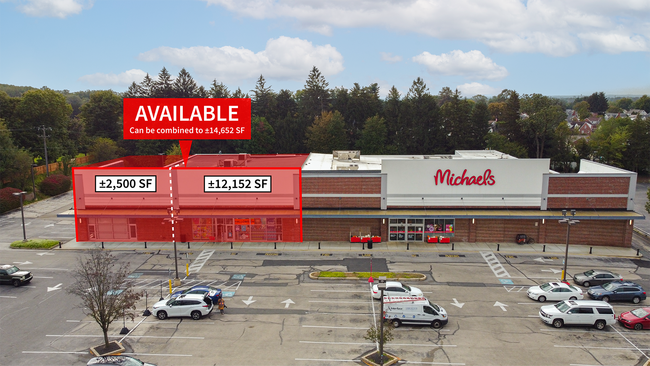

Current Lease Availabilities
General Retail LEASE
Negotiable
2,500 - 12,152 SF
Property Detail
601 Baltimore Pike
42-00-00393-00
1 STY BLDG ADD 4AC
Restaurantbuilding
DELAWARE
B and X Area of moderate flood hazard, usually the area between the limits of the 100-year and 500-year floods.
Pennsylvania
2024
4 AC
2025
Delaware County
407805
Philadelphia
38,508 SF
Philadelphia-Camden-Wilmington, PA-NJ-DE-MD
NEARBY LISTINGS FOR SALE OR LEASE
DEMOGRAPHICS near 601 Baltimore Pike
1 mile
3 mile
5 mile
2024 Total Population
17,706
161,793
419,697
2029 Population
17,935
163,247
423,188
Pop Growth 2024-2029
+ 1.29%
+ 0.90%
+ 0.83%
Average Age
41
41
40
2024 Total Households
6,689
62,356
158,521
HH Growth 2024-2029
+ 1.48%
+ 0.94%
+ 0.89%
Median Household Inc
$103,031
$87,910
$75,115
Avg Household Size
2.60
2.50
2.60
2024 Avg HH Vehicles
2.00
2.00
2.00
Median Home Value
$350,839
$285,098
$275,341
Median Year Built
1956
1953
1953
Nearby Places
Map Layers
Map Styles
 Street
 Aerial
Transit
 Traffic
 Biking
Places
Listings with unknown addresses are not visible on the map
- Restaurants
- Banks
- Shops
- Fitness
- Groceries
PUBLIC TRANSPORTATION
TRANSIT/SUBWAY
Saxer Avenue (Route 101 - Southeastern Pennsylvania Transportation Authority Rapid Transit (SEPTA Subway & Trolley))
Drive
Walk
Distance
Saxer Avenue (Route 101 - Southeastern Pennsylvania Transportation Authority Rapid Transit (SEPTA Subway & Trolley))
3 min
17 min
0.8 mi
Leamy Avenue (Route 101 - Southeastern Pennsylvania Transportation Authority Rapid Transit (SEPTA Subway & Trolley))
Drive
Walk
Distance
Leamy Avenue (Route 101 - Southeastern Pennsylvania Transportation Authority Rapid Transit (SEPTA Subway & Trolley))
3 min
18 min
0.9 mi
COMMUTER RAIL
Morton (R3 - Southeastern Pennsylvania Transportation Authority Regional Rail (SEPTA Regional Rail))
Drive
Walk
Distance
Morton (R3 - Southeastern Pennsylvania Transportation Authority Regional Rail (SEPTA Regional Rail))
4 min
1.3 mi
Secane (R3 - Southeastern Pennsylvania Transportation Authority Regional Rail (SEPTA Regional Rail))
Drive
Walk
Distance
Secane (R3 - Southeastern Pennsylvania Transportation Authority Regional Rail (SEPTA Regional Rail))
4 min
1.4 mi
AIRPORT
Philadelphia International
Drive
Walk
Distance
Philadelphia International
18 min
7.8 mi
Freight Ports
Broadway Terminal - Pier 5
Drive
Walk
Distance
Broadway Terminal - Pier 5
32 min
15.0 mi
Nearby Properties
Address
Land Use
TOTAL SIZE
Lot Size
Zoning
Address
Land Use
TOTAL SIZE
Lot Size
Zoning
6,637 SF
198.92 AC
Address
Land Use
TOTAL SIZE
Lot Size
Zoning
175,978 SF
15.95 AC
Address
Land Use
TOTAL SIZE
Lot Size
Zoning
15,660 SF
56.60 AC
Address
Land Use
TOTAL SIZE
Lot Size
Zoning
48,739 SF
30 AC
Address
Land Use
TOTAL SIZE
Lot Size
Zoning
702,532 SF
11 AC
Address
Land Use
TOTAL SIZE
Lot Size
Zoning
20,880 SF
27.20 AC
Address
Land Use
TOTAL SIZE
Lot Size
Zoning
6,040 SF
16.45 AC
Address
Land Use
TOTAL SIZE
Lot Size
Zoning
241,578 SF
14 AC
Address
Land Use
TOTAL SIZE
Lot Size
Zoning
136,972 SF
27 AC
Address
Land Use
TOTAL SIZE
Lot Size
Zoning
312,988 SF
24 AC
Address
Land Use
TOTAL SIZE
Lot Size
Zoning
255,316 SF
6 AC
Address
Land Use
TOTAL SIZE
Lot Size
Zoning
61,860 SF
6.29 AC
Address
Land Use
TOTAL SIZE
Lot Size
Zoning
2,608 SF
198.92 AC
Address
Land Use
TOTAL SIZE
Lot Size
Zoning
2,562 SF
198.92 AC
Address
Land Use
TOTAL SIZE
Lot Size
Zoning
170,442 SF
26.04 AC
Address
Land Use
TOTAL SIZE
Lot Size
Zoning
12,100 SF
7 AC
Address
Land Use
TOTAL SIZE
Lot Size
Zoning
215,557 SF
22 AC
Address
Land Use
TOTAL SIZE
Lot Size
Zoning
261,618 SF
30.57 AC
Address
Land Use
TOTAL SIZE
Lot Size
Zoning
702,532 SF
Address
Land Use
TOTAL SIZE
Lot Size
Zoning
68,096 SF
7.78 AC
Address
Land Use
TOTAL SIZE
Lot Size
Zoning
282,520 SF
24.44 AC
Address
Land Use
TOTAL SIZE
Lot Size
Zoning
187,056 SF
16 AC
Address
Land Use
TOTAL SIZE
Lot Size
Zoning
164,834 SF
13 AC
Address
Land Use
TOTAL SIZE
Lot Size
Zoning
60,588 SF
9.43 AC
Address
Land Use
TOTAL SIZE
Lot Size
Zoning
110,424 SF
5.32 AC
Address
Land Use
TOTAL SIZE
Lot Size
Zoning
122,018 SF
16.24 AC
Address
Land Use
TOTAL SIZE
Lot Size
Zoning
90,368 SF
124 AC
Address
Land Use
TOTAL SIZE
Lot Size
Zoning
150,450 SF
9 AC
Address
Land Use
TOTAL SIZE
Lot Size
Zoning
51,280 SF
7 AC
Address
Land Use
TOTAL SIZE
Lot Size
Zoning
152,403 SF
16.98 AC
The World's #1 Commercial Real Estate Marketplace
Connect with us
© 2026 CoStar Group
The information above has been obtained from sources believed reliable. While we do not doubt its accuracy we have not verified it and make no guarantee, warranty or representation about it. It is your responsibility to independently confirm its accuracy and completeness. Any projections, opinions, assumptions, or estimates used are for example only and do not represent the current or future performance of the property. The value of this transaction to you depends on tax and other factors which should be evaluated by your tax, financial, and legal advisors. You and your advisors should conduct a careful, independent investigation of the property to determine to your satisfaction the suitability of the property for your needs.