Property Record
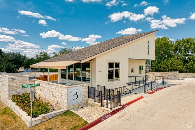
601 Conservation Dr, Austin, TX 78717


Property Detail
601 Conservation Dr
R594839
C535 - GREAT OAKS AT BRUSHY CREEK TOWNHOMES, BUILDING 6, UNIT 31, 3.22% COMMON AREA INTEREST
Commercialnec
WILLIAMSON
B and X Area of moderate flood hazard, usually the area between the limits of the 100-year and 500-year floods.
Texas
2024
0.09 AC
2025
Round Rock
020509
Austin
704 SF
Austin-Round Rock-San Marcos, TX
NEARBY LISTINGS FOR SALE OR LEASE
DEMOGRAPHICS near 601 Conservation Dr
1 mile
3 mile
5 mile
2024 Total Population
17,336
82,072
235,661
2029 Population
21,673
103,261
295,064
Pop Growth 2024-2029
+ 25.02%
+ 25.82%
+ 25.21%
Average Age
38
37
36
2024 Total Households
5,932
27,957
91,330
HH Growth 2024-2029
+ 25.42%
+ 26.37%
+ 25.63%
Median Household Inc
$124,309
$131,351
$93,267
Avg Household Size
2.90
2.90
2.50
2024 Avg HH Vehicles
2.00
2.00
2.00
Median Home Value
$431,964
$463,322
$419,840
Median Year Built
1995
2001
2002
Nearby Places
Map Layers
Map Styles
 Street
 Aerial
Transit
 Traffic
 Biking
Places
Listings with unknown addresses are not visible on the map
- Restaurants
- Banks
- Shops
- Fitness
- Groceries
PUBLIC TRANSPORTATION
AIRPORT
Austin-Bergstrom International
Drive
Walk
Distance
Austin-Bergstrom International
45 min
31.2 mi
Freight Ports
Calhoun Port
Drive
Walk
Distance
Calhoun Port
207 min
180.5 mi
SALE & LEASE HISTORY
LISTING DATE
SALE/LEASE

May 19, 2022
For Sale
May 10, 2021
For Sale
Feb 13, 2018
For Sale
Nearby Properties
Address
Land Use
TOTAL SIZE
Lot Size
Zoning
Address
Land Use
TOTAL SIZE
Lot Size
Zoning
536,741 SF
80.32 AC
SF2
Address
Land Use
TOTAL SIZE
Lot Size
Zoning
757,866 SF
33.21 AC
Address
Land Use
TOTAL SIZE
Lot Size
Zoning
325,797 SF
36.36 AC
Address
Land Use
TOTAL SIZE
Lot Size
Zoning
493,699 SF
28.29 AC
Address
Land Use
TOTAL SIZE
Lot Size
Zoning
420,181 SF
18.86 AC
Address
Land Use
TOTAL SIZE
Lot Size
Zoning
350,637 SF
10.36 AC
Address
Land Use
TOTAL SIZE
Lot Size
Zoning
408,335 SF
31.16 AC
Address
Land Use
TOTAL SIZE
Lot Size
Zoning
1,152,630 SF
23.29 AC
Address
Land Use
TOTAL SIZE
Lot Size
Zoning
337,685 SF
14.35 AC
Address
Land Use
TOTAL SIZE
Lot Size
Zoning
356,499 SF
9.39 AC
Address
Land Use
TOTAL SIZE
Lot Size
Zoning
323,820 SF
14.31 AC
Address
Land Use
TOTAL SIZE
Lot Size
Zoning
303,240 SF
16.71 AC
Address
Land Use
TOTAL SIZE
Lot Size
Zoning
322,935 SF
20 AC
Address
Land Use
TOTAL SIZE
Lot Size
Zoning
351,168 SF
19.69 AC
Address
Land Use
TOTAL SIZE
Lot Size
Zoning
308,610 SF
22.99 AC
Address
Land Use
TOTAL SIZE
Lot Size
Zoning
439,049 SF
17.47 AC
Address
Land Use
TOTAL SIZE
Lot Size
Zoning
467,165 SF
59.87 AC
Address
Land Use
TOTAL SIZE
Lot Size
Zoning
330,685 SF
20.17 AC
Address
Land Use
TOTAL SIZE
Lot Size
Zoning
255,253 SF
26.57 AC
Address
Land Use
TOTAL SIZE
Lot Size
Zoning
270,142 SF
16.51 AC
Address
Land Use
TOTAL SIZE
Lot Size
Zoning
370,410 SF
46.86 AC
Address
Land Use
TOTAL SIZE
Lot Size
Zoning
278,392 SF
10.72 AC
Address
Land Use
TOTAL SIZE
Lot Size
Zoning
219,758 SF
11 AC
Address
Land Use
TOTAL SIZE
Lot Size
Zoning
211,785 SF
48.79 AC
Address
Land Use
TOTAL SIZE
Lot Size
Zoning
30.71 AC
Address
Land Use
TOTAL SIZE
Lot Size
Zoning
93,748 SF
5.11 AC
PF3
Address
Land Use
TOTAL SIZE
Lot Size
Zoning
103,865 SF
8.44 AC
Address
Land Use
TOTAL SIZE
Lot Size
Zoning
114,942 SF
18 AC
Address
Land Use
TOTAL SIZE
Lot Size
Zoning
122,500 SF
29.71 AC
Address
Land Use
TOTAL SIZE
Lot Size
Zoning
313,866 SF
11.95 AC
The World's #1 Commercial Real Estate Marketplace
Connect with us
© 2026 CoStar Group
The information above has been obtained from sources believed reliable. While we do not doubt its accuracy we have not verified it and make no guarantee, warranty or representation about it. It is your responsibility to independently confirm its accuracy and completeness. Any projections, opinions, assumptions, or estimates used are for example only and do not represent the current or future performance of the property. The value of this transaction to you depends on tax and other factors which should be evaluated by your tax, financial, and legal advisors. You and your advisors should conduct a careful, independent investigation of the property to determine to your satisfaction the suitability of the property for your needs.