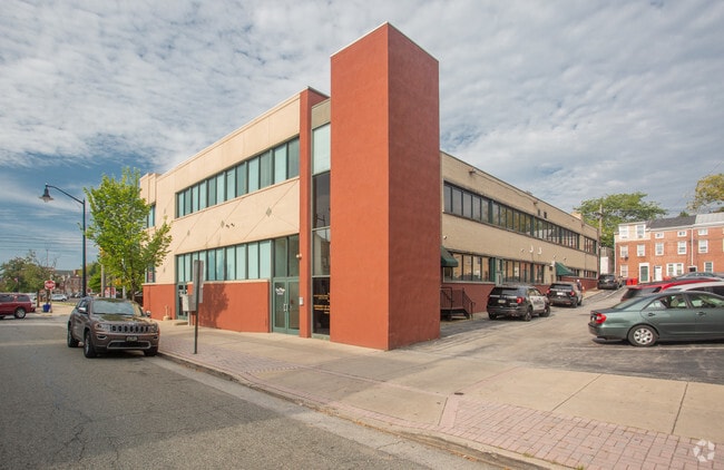
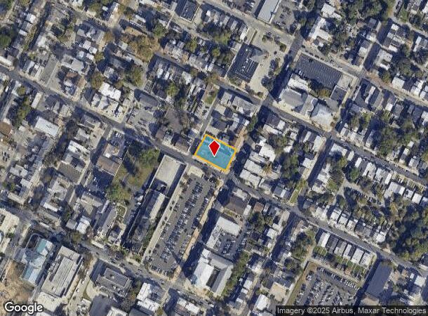
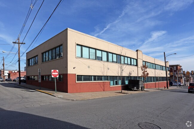
Property Record
601 Dekalb St, Norristown, PA 19401
NEARBY LISTINGS FOR SALE OR LEASE
Property Detail
601 Dekalb St
13-00-09948-002
ASSESSOR BLOCK-UNIT NUMBER 23-79
Officebuilding
Montgomery
X
Pennsylvania
42029C0120G
79
2024
0.34 AC
2025
Norristown/Valley Forge
203901
Philadelphia
21,816 SF
Philadelphia-Camden-Wilmington, PA-NJ-DE-MD
DEMOGRAPHICS near 601 Dekalb St
1 Mile
3 Mile
5 Mile
2024 Total Population
31,476
101,002
195,951
2029 Population
32,002
102,933
199,916
Pop Growth 2024-2029
+ 1.67%
+ 1.91%
+ 2.02%
Average Age
35
40
40
2024 Total Households
11,136
39,928
78,645
HH Growth 2024-2029
+ 1.73%
+ 1.98%
+ 2.15%
Median Household Inc
$50,955
$79,889
$99,075
Avg Household Size
2.60
2.40
2.40
2024 Avg HH Vehicles
1.00
2.00
2.00
Median Home Value
$168,965
$287,860
$372,206
Median Year Built
1949
1963
1970
Nearby Places
Map Layers
Map Styles
 Street
 Aerial
- Restaurants
- Banks
- Shops
- Fitness
- Groceries
PUBLIC TRANSPORTATION
TRANSIT/SUBWAY
Norristown Transportation Center (100 Line) (Norristown High Speed Line - SEPTA, Route 100 - SEPTA)
DRIVE
WALK
Distance
Norristown Transportation Center (100 Line) (Norristown High Speed Line - SEPTA, Route 100 - SEPTA)
1 min
9 min
0.4 mi
Bridgeport (Norristown High Speed Line - SEPTA, Route 100 - SEPTA)
DRIVE
WALK
Distance
Bridgeport (Norristown High Speed Line - SEPTA, Route 100 - SEPTA)
5 min
19 min
1.0 mi
COMMUTER RAIL
Norristown Transportation Center (R6 Line) (Manayunk/Norristown Line - SEPTA, R6 - SEPTA)
DRIVE
WALK
Distance
Norristown Transportation Center (R6 Line) (Manayunk/Norristown Line - SEPTA, R6 - SEPTA)
2 min
7 min
0.4 mi
Elm Street (Norristown) (R6 - Southeastern Pennsylvania Transportation Authority Regional Rail (SEPTA Regional Rail))
DRIVE
WALK
Distance
Elm Street (Norristown) (R6 - Southeastern Pennsylvania Transportation Authority Regional Rail (SEPTA Regional Rail))
1 min
15 min
0.6 mi
AIRPORT
Philadelphia International
DRIVE
WALK
Distance
Philadelphia International
43 min
27.3 mi
Trenton Mercer
DRIVE
WALK
Distance
Trenton Mercer
53 min
38.3 mi
Freight Ports
Port of Philadelphia
DRIVE
WALK
Distance
Port of Philadelphia
39 min
23.2 mi
SALE & LEASE HISTORY
LISTING DATE
SALE/LEASE

Sep 25, 2016
For Lease
Sep 25, 2016
For Lease
Mar 22, 2018
For Lease
Dec 04, 2018
For Lease
Nearby Properties
Address
Land Use
TOTAL SIZE
Lot Size
Zoning
Address
Land Use
TOTAL SIZE
Lot Size
Zoning
1,807,465 SF
120.12 AC
R2
Address
Land Use
TOTAL SIZE
Lot Size
Zoning
365,348 SF
80.44 AC
IN
Address
Land Use
TOTAL SIZE
Lot Size
Zoning
679,715 SF
58.23 AC
R2
Address
Land Use
TOTAL SIZE
Lot Size
Zoning
469,066 SF
47 AC
MU
Address
Land Use
TOTAL SIZE
Lot Size
Zoning
872,232 SF
51.99 AC
G
Address
Land Use
TOTAL SIZE
Lot Size
Zoning
422,975 SF
92.05 AC
RA
Address
Land Use
TOTAL SIZE
Lot Size
Zoning
843,567 SF
50.79 AC
HI
Address
Land Use
TOTAL SIZE
Lot Size
Zoning
197,108 SF
2.08 AC
SC
Address
Land Use
TOTAL SIZE
Lot Size
Zoning
217,564 SF
12.64 AC
IN
Address
Land Use
TOTAL SIZE
Lot Size
Zoning
231,665 SF
26.34 AC
OSR
Address
Land Use
TOTAL SIZE
Lot Size
Zoning
804,184 SF
26.72 AC
HR
Address
Land Use
TOTAL SIZE
Lot Size
Zoning
381,496 SF
5.37 AC
EC
Address
Land Use
TOTAL SIZE
Lot Size
Zoning
370,404 SF
15.55 AC
SM1
Address
Land Use
TOTAL SIZE
Lot Size
Zoning
961,106 SF
5.47 AC
LI
Address
Land Use
TOTAL SIZE
Lot Size
Zoning
452,740 SF
11.03 AC
C
Address
Land Use
TOTAL SIZE
Lot Size
Zoning
310,900 SF
55.48 AC
HI
Address
Land Use
TOTAL SIZE
Lot Size
Zoning
320,804 SF
30.85 AC
CR
Address
Land Use
TOTAL SIZE
Lot Size
Zoning
512,846 SF
9.50 AC
HRA
Address
Land Use
TOTAL SIZE
Lot Size
Zoning
333,974 SF
18.56 AC
HR
Address
Land Use
TOTAL SIZE
Lot Size
Zoning
667,719 SF
23.73 AC
BP
Address
Land Use
TOTAL SIZE
Lot Size
Zoning
320,737 SF
0.98 AC
TC
Address
Land Use
TOTAL SIZE
Lot Size
Zoning
416,392 SF
26.56 AC
HR
Address
Land Use
TOTAL SIZE
Lot Size
Zoning
298,856 SF
9.58 AC
HR
Address
Land Use
TOTAL SIZE
Lot Size
Zoning
118,981 SF
4.24 AC
SM1
Address
Land Use
TOTAL SIZE
Lot Size
Zoning
225,196 SF
14.87 AC
AR
Address
Land Use
TOTAL SIZE
Lot Size
Zoning
299,018 SF
9.42 AC
SC
Address
Land Use
TOTAL SIZE
Lot Size
Zoning
311,784 SF
21.82 AC
A
Address
Land Use
TOTAL SIZE
Lot Size
Zoning
136,637 SF
18 AC
OSR
Address
Land Use
TOTAL SIZE
Lot Size
Zoning
216,300 SF
16.33 AC
LI
Address
Land Use
TOTAL SIZE
Lot Size
Zoning
211,739 SF
14.14 AC
CR
The World's #1 Commercial Real Estate Marketplace
Connect with us
© 2025 CoStar Group
The information above has been obtained from sources believed reliable. While we do not doubt its accuracy we have not verified it and make no guarantee, warranty or representation about it. It is your responsibility to independently confirm its accuracy and completeness. Any projections, opinions, assumptions, or estimates used are for example only and do not represent the current or future performance of the property. The value of this transaction to you depends on tax and other factors which should be evaluated by your tax, financial, and legal advisors. You and your advisors should conduct a careful, independent investigation of the property to determine to your satisfaction the suitability of the property for your needs.