Property Record
601 E 3Rd St, Little Rock, AR 72201
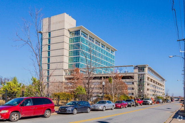
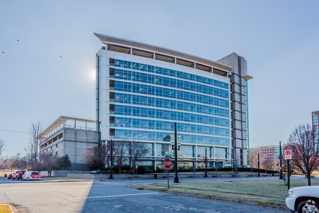
Property Detail
601 E 3Rd St
Little Rock-North Little Rock-Conway, AR
LESS AND EXCEPT PART OF LOT 1 SIMMONS BANK ADDITION MPDAF BEG AT POINT BEING USED AS SW CORNER OF LOT 1 TH ALON CURVE TO THE RIGHT HAVING A R OF 20 FT AND A CHORD BEARING N37*0542W 29.09 FT TH S37*0542E 29.09 FT TO POB CONT 126 SQ FT MORE OR LESS
34L-019-12-002-00
PULASKI
Officebuilding
Arkansas
B and X Area of moderate flood hazard, usually the area between the limits of the 100-year and 500-year floods.
1
2025
2.44 AC
2025
Downtown
004400
Little Rock/N Little Rock
32,248 SF
NEARBY LISTINGS FOR SALE OR LEASE
DEMOGRAPHICS near 601 E 3Rd St
1 mile
3 mile
5 mile
2025 Total Population
5,664
44,128
113,256
2030 Population
5,789
45,570
115,085
Pop Growth 2025-2030
+ 2.21%
+ 3.27%
+ 1.61%
Average Age
42
40
40
2025 Total Households
3,620
20,840
51,541
HH Growth 2025-2030
+ 2.10%
+ 3.18%
+ 1.62%
Median Household Inc
$58,416
$43,691
$51,826
Avg Household Size
1.50
1.90
2.10
2025 Avg HH Vehicles
1.00
1.00
1.00
Median Home Value
$265,273
$178,986
$182,620
Median Year Built
1966
1961
1966
Nearby Places
Map Layers
Map Styles
 Street
 Aerial
Layers
 Traffic
 Biking
Places
Listings with unknown addresses are not visible on the map
- Restaurants
- Banks
- Shops
- Fitness
- Groceries
PUBLIC TRANSPORTATION
TRANSIT/SUBWAY
President Clinton Ave & River Market Ave (Blue Line Streetcar - Rock Region Metro)
Drive
Walk
Distance
President Clinton Ave & River Market Ave (Blue Line Streetcar - Rock Region Metro)
1 min
4 min
0.2 mi
2Nd St & Rock St (Blue Line Streetcar - Rock Region Metro)
Drive
Walk
Distance
2Nd St & Rock St (Blue Line Streetcar - Rock Region Metro)
1 min
5 min
0.3 mi
2Nd St & Scott St (Blue Line Streetcar - Rock Region Metro)
Drive
Walk
Distance
2Nd St & Scott St (Blue Line Streetcar - Rock Region Metro)
1 min
6 min
0.4 mi
West Markham & Scott St - Marriott (Blue Line Streetcar - Rock Region Metro)
Drive
Walk
Distance
West Markham & Scott St - Marriott (Blue Line Streetcar - Rock Region Metro)
1 min
9 min
0.5 mi
2Nd St & Center St (Blue Line Streetcar - Rock Region Metro)
Drive
Walk
Distance
2Nd St & Center St (Blue Line Streetcar - Rock Region Metro)
1 min
11 min
0.6 mi
COMMUTER RAIL
Little Rock Union Station (Texas Eagle - Amtrak)
Drive
Walk
Distance
Little Rock Union Station (Texas Eagle - Amtrak)
3 min
1.6 mi
AIRPORT
Bill and Hillary Clinton Ntl/Adams Field
Drive
Walk
Distance
Bill and Hillary Clinton Ntl/Adams Field
9 min
4.1 mi
Freight Ports
Port of Shreveport
Drive
Walk
Distance
Port of Shreveport
251 min
233.6 mi
Nearby Properties
Address
Land Use
TOTAL SIZE
Lot Size
Zoning
Address
Land Use
TOTAL SIZE
Lot Size
Zoning
1.80 AC
Address
Land Use
TOTAL SIZE
Lot Size
Zoning
0.90 AC
Address
Land Use
TOTAL SIZE
Lot Size
Zoning
0.45 AC
Address
Land Use
TOTAL SIZE
Lot Size
Zoning
1,000,000 SF
9.38 AC
Address
Land Use
TOTAL SIZE
Lot Size
Zoning
333,096 SF
11.62 AC
Address
Land Use
TOTAL SIZE
Lot Size
Zoning
237,144 SF
1.26 AC
Address
Land Use
TOTAL SIZE
Lot Size
Zoning
526,829 SF
33.78 AC
Address
Land Use
TOTAL SIZE
Lot Size
Zoning
180,616 SF
0.91 AC
Address
Land Use
TOTAL SIZE
Lot Size
Zoning
12,562 SF
2.26 AC
Address
Land Use
TOTAL SIZE
Lot Size
Zoning
412,597 SF
Address
Land Use
TOTAL SIZE
Lot Size
Zoning
297,814 SF
86.09 AC
Address
Land Use
TOTAL SIZE
Lot Size
Zoning
22,017 SF
2.06 AC
Address
Land Use
TOTAL SIZE
Lot Size
Zoning
305,882 SF
7.82 AC
Address
Land Use
TOTAL SIZE
Lot Size
Zoning
761,810 SF
75.61 AC
Address
Land Use
TOTAL SIZE
Lot Size
Zoning
2,636 SF
0.67 AC
Address
Land Use
TOTAL SIZE
Lot Size
Zoning
267,152 SF
Address
Land Use
TOTAL SIZE
Lot Size
Zoning
137,538 SF
31.58 AC
Address
Land Use
TOTAL SIZE
Lot Size
Zoning
260,000 SF
5.80 AC
Address
Land Use
TOTAL SIZE
Lot Size
Zoning
143,553 SF
12.76 AC
Address
Land Use
TOTAL SIZE
Lot Size
Zoning
130,742 SF
15.71 AC
Address
Land Use
TOTAL SIZE
Lot Size
Zoning
95,719 SF
32.76 AC
Address
Land Use
TOTAL SIZE
Lot Size
Zoning
346,974 SF
Address
Land Use
TOTAL SIZE
Lot Size
Zoning
138,352 SF
2.95 AC
Address
Land Use
TOTAL SIZE
Lot Size
Zoning
61,225 SF
5.66 AC
Address
Land Use
TOTAL SIZE
Lot Size
Zoning
269,624 SF
3.40 AC
Address
Land Use
TOTAL SIZE
Lot Size
Zoning
361,910 SF
Address
Land Use
TOTAL SIZE
Lot Size
Zoning
41,925 SF
13 AC
Address
Land Use
TOTAL SIZE
Lot Size
Zoning
83,652 SF
12.55 AC
Address
Land Use
TOTAL SIZE
Lot Size
Zoning
220,800 SF
2.92 AC
Address
Land Use
TOTAL SIZE
Lot Size
Zoning
9,272 SF
0.58 AC
The World's #1 Commercial Real Estate Marketplace
Connect with us
© 2026 CoStar Group
The information above has been obtained from sources believed reliable. While we do not doubt its accuracy we have not verified it and make no guarantee, warranty or representation about it. It is your responsibility to independently confirm its accuracy and completeness. Any projections, opinions, assumptions, or estimates used are for example only and do not represent the current or future performance of the property. The value of this transaction to you depends on tax and other factors which should be evaluated by your tax, financial, and legal advisors. You and your advisors should conduct a careful, independent investigation of the property to determine to your satisfaction the suitability of the property for your needs.