Property Record
601 E Main St, Kutztown, PA 19530


NEARBY LISTINGS FOR SALE OR LEASE
-
-
View all Kutztown listings for lease on LoopNet.com
Property Detail
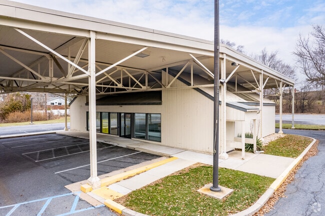
601 E Main St
Financialbuilding
Berks
X
Pennsylvania
42011C0194G
0.83 AC
2025
Berks County
2025
Philadelphia
011705
Reading, PA
2,730 SF
55-5454-17-01-9232
DEMOGRAPHICS near 601 E Main St
1 Mile
3 Mile
5 Mile
2024 Total Population
3,656
9,455
20,193
2029 Population
3,701
9,540
20,322
Pop Growth 2024-2029
+ 1.23%
+ 0.90%
+ 0.64%
Average Age
41
38
42
2024 Total Households
1,555
3,444
7,743
HH Growth 2024-2029
+ 1.35%
+ 1.13%
+ 0.74%
Median Household Inc
$54,482
$55,744
$69,398
Avg Household Size
2.20
2.30
2.30
2024 Avg HH Vehicles
2.00
2.00
2.00
Median Home Value
$201,181
$216,259
$238,497
Median Year Built
1962
1964
1968
Nearby Places
Map Layers
Map Styles
 Street
 Aerial
- Restaurants
- Banks
- Shops
- Fitness
- Groceries
PUBLIC TRANSPORTATION
AIRPORT
Lehigh Valley International
DRIVE
WALK
Distance
Lehigh Valley International
36 min
22.4 mi
Freight Ports
Port of Philadelphia
DRIVE
WALK
Distance
Port of Philadelphia
93 min
69.9 mi
SALE & LEASE HISTORY
LISTING DATE
SALE/LEASE

Oct 06, 2021
For Lease
May 01, 2018
For Sale
Jun 07, 2023
For Lease
Dec 08, 2022
For Sale
Aug 14, 2018
For Sale
Nearby Properties
Address
Land Use
TOTAL SIZE
Lot Size
Zoning
Address
Land Use
TOTAL SIZE
Lot Size
Zoning
31,697 SF
22.56 AC
Address
Land Use
TOTAL SIZE
Lot Size
Zoning
159,366 SF
0.74 AC
Address
Land Use
TOTAL SIZE
Lot Size
Zoning
1,296,835 SF
265.85 AC
Address
Land Use
TOTAL SIZE
Lot Size
Zoning
69,966 SF
30.10 AC
Address
Land Use
TOTAL SIZE
Lot Size
Zoning
53,353 SF
3.81 AC
Address
Land Use
TOTAL SIZE
Lot Size
Zoning
33,632 SF
2.90 AC
Address
Land Use
TOTAL SIZE
Lot Size
Zoning
21,840 SF
16.68 AC
Address
Land Use
TOTAL SIZE
Lot Size
Zoning
40,772 SF
11.19 AC
Address
Land Use
TOTAL SIZE
Lot Size
Zoning
120,641 SF
12.95 AC
Address
Land Use
TOTAL SIZE
Lot Size
Zoning
38,956 SF
4.90 AC
Address
Land Use
TOTAL SIZE
Lot Size
Zoning
10,770 SF
13.06 AC
Address
Land Use
TOTAL SIZE
Lot Size
Zoning
39,104 SF
4.06 AC
Address
Land Use
TOTAL SIZE
Lot Size
Zoning
245,468 SF
9.93 AC
Address
Land Use
TOTAL SIZE
Lot Size
Zoning
13,440 SF
8.23 AC
Address
Land Use
TOTAL SIZE
Lot Size
Zoning
45,423 SF
17.25 AC
Address
Land Use
TOTAL SIZE
Lot Size
Zoning
266,451 SF
59.37 AC
Address
Land Use
TOTAL SIZE
Lot Size
Zoning
7,806 SF
0.50 AC
Address
Land Use
TOTAL SIZE
Lot Size
Zoning
27,880 SF
16.60 AC
Address
Land Use
TOTAL SIZE
Lot Size
Zoning
12,692 SF
3.68 AC
Address
Land Use
TOTAL SIZE
Lot Size
Zoning
14,797 SF
1.45 AC
Address
Land Use
TOTAL SIZE
Lot Size
Zoning
33,100 SF
5.58 AC
Address
Land Use
TOTAL SIZE
Lot Size
Zoning
221,411 SF
23.93 AC
Address
Land Use
TOTAL SIZE
Lot Size
Zoning
68,606 SF
10.15 AC
Address
Land Use
TOTAL SIZE
Lot Size
Zoning
15,458 SF
1.45 AC
Address
Land Use
TOTAL SIZE
Lot Size
Zoning
17,072 SF
1.41 AC
Address
Land Use
TOTAL SIZE
Lot Size
Zoning
10,431 SF
75.73 AC
Address
Land Use
TOTAL SIZE
Lot Size
Zoning
38,357 SF
4.95 AC
Address
Land Use
TOTAL SIZE
Lot Size
Zoning
13.88 AC
Address
Land Use
TOTAL SIZE
Lot Size
Zoning
17,379 SF
9.59 AC
Address
Land Use
TOTAL SIZE
Lot Size
Zoning
1,883 SF
18.83 AC
The World's #1 Commercial Real Estate Marketplace
Connect with us
© 2026 CoStar Group
The information above has been obtained from sources believed reliable. While we do not doubt its accuracy we have not verified it and make no guarantee, warranty or representation about it. It is your responsibility to independently confirm its accuracy and completeness. Any projections, opinions, assumptions, or estimates used are for example only and do not represent the current or future performance of the property. The value of this transaction to you depends on tax and other factors which should be evaluated by your tax, financial, and legal advisors. You and your advisors should conduct a careful, independent investigation of the property to determine to your satisfaction the suitability of the property for your needs.