Property Record
601 E Main St, Weatherford, OK 73096


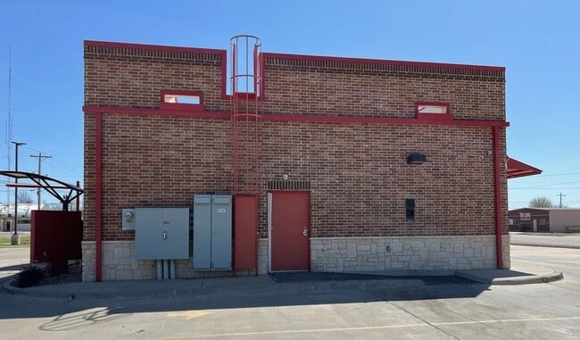
Property Detail
601 E Main St
Weatherford, OK
WEATHERFORD CITY TRACTS HUBER TRACTS S150' OF TR E7
0701-00-000-0E7-0-000-00
CUSTER
Restaurantdrivein
Oklahoma
B and X Area of moderate flood hazard, usually the area between the limits of the 100-year and 500-year floods.
e7
2025
0.40 AC
2025
Oklahoma West Area
960701
Other Market Areas
3,176 SF
NEARBY LISTINGS FOR SALE OR LEASE
DEMOGRAPHICS near 601 E Main St
1 mile
3 mile
5 mile
2024 Total Population
7,774
13,880
14,645
2029 Population
7,815
13,893
14,655
Pop Growth 2024-2029
+ 0.53%
+ 0.09%
+ 0.07%
Average Age
33
34
35
2024 Total Households
2,958
5,409
5,702
HH Growth 2024-2029
+ 0.74%
+ 0.18%
+ 0.16%
Median Household Inc
$40,808
$55,754
$57,006
Avg Household Size
2.20
2.30
2.30
2024 Avg HH Vehicles
2.00
2.00
2.00
Median Home Value
$184,235
$211,603
$216,450
Median Year Built
1979
1983
1983
Nearby Places
Map Layers
Map Styles
 Street
 Aerial
Transit
 Traffic
 Biking
Places
Listings with unknown addresses are not visible on the map
- Restaurants
- Banks
- Shops
- Fitness
- Groceries
SALE & LEASE HISTORY
LISTING DATE
SALE/LEASE

May 14, 2025
For Lease
May 14, 2025
For Sale
Nearby Properties
Address
Land Use
TOTAL SIZE
Lot Size
Zoning
Address
Land Use
TOTAL SIZE
Lot Size
Zoning
21.20 AC
Address
Land Use
TOTAL SIZE
Lot Size
Zoning
14,608 SF
51.39 AC
Address
Land Use
TOTAL SIZE
Lot Size
Zoning
21,206 SF
2.97 AC
Address
Land Use
TOTAL SIZE
Lot Size
Zoning
152,845 SF
20.19 AC
Address
Land Use
TOTAL SIZE
Lot Size
Zoning
22,590 SF
10.50 AC
Address
Land Use
TOTAL SIZE
Lot Size
Zoning
22,421 SF
2 AC
Address
Land Use
TOTAL SIZE
Lot Size
Zoning
8,000 SF
34.36 AC
Address
Land Use
TOTAL SIZE
Lot Size
Zoning
4,543 SF
0.32 AC
Address
Land Use
TOTAL SIZE
Lot Size
Zoning
63,328 SF
2.56 AC
Address
Land Use
TOTAL SIZE
Lot Size
Zoning
43,320 SF
7.03 AC
Address
Land Use
TOTAL SIZE
Lot Size
Zoning
6,016 SF
7.90 AC
Address
Land Use
TOTAL SIZE
Lot Size
Zoning
8,694 SF
3 AC
Address
Land Use
TOTAL SIZE
Lot Size
Zoning
6.28 AC
Address
Land Use
TOTAL SIZE
Lot Size
Zoning
11,284 SF
0.72 AC
Address
Land Use
TOTAL SIZE
Lot Size
Zoning
19,839 SF
60 AC
NP
Address
Land Use
TOTAL SIZE
Lot Size
Zoning
6,220 SF
4.50 AC
Address
Land Use
TOTAL SIZE
Lot Size
Zoning
57,132 SF
6.26 AC
Address
Land Use
TOTAL SIZE
Lot Size
Zoning
11,070 SF
5.37 AC
Address
Land Use
TOTAL SIZE
Lot Size
Zoning
9,120 SF
1.40 AC
Address
Land Use
TOTAL SIZE
Lot Size
Zoning
10,920 SF
6.91 AC
Address
Land Use
TOTAL SIZE
Lot Size
Zoning
9,600 SF
6.06 AC
Address
Land Use
TOTAL SIZE
Lot Size
Zoning
12,600 SF
8.84 AC
Address
Land Use
TOTAL SIZE
Lot Size
Zoning
22,842 SF
1.66 AC
Address
Land Use
TOTAL SIZE
Lot Size
Zoning
Address
Land Use
TOTAL SIZE
Lot Size
Zoning
40,053 SF
1.77 AC
Address
Land Use
TOTAL SIZE
Lot Size
Zoning
52,130 SF
5 AC
Address
Land Use
TOTAL SIZE
Lot Size
Zoning
21,639 SF
2.93 AC
Address
Land Use
TOTAL SIZE
Lot Size
Zoning
30,044 SF
4.03 AC
Address
Land Use
TOTAL SIZE
Lot Size
Zoning
4,054 SF
1.09 AC
Address
Land Use
TOTAL SIZE
Lot Size
Zoning
2,560 SF
0.14 AC
The World's #1 Commercial Real Estate Marketplace
Connect with us
© 2026 CoStar Group
The information above has been obtained from sources believed reliable. While we do not doubt its accuracy we have not verified it and make no guarantee, warranty or representation about it. It is your responsibility to independently confirm its accuracy and completeness. Any projections, opinions, assumptions, or estimates used are for example only and do not represent the current or future performance of the property. The value of this transaction to you depends on tax and other factors which should be evaluated by your tax, financial, and legal advisors. You and your advisors should conduct a careful, independent investigation of the property to determine to your satisfaction the suitability of the property for your needs.