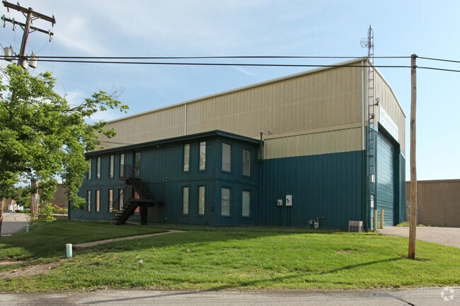
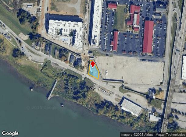
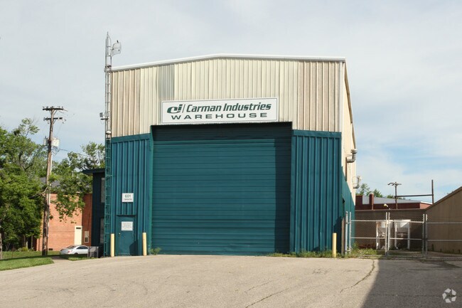
Property Record
601 E Riverside Dr, Clarksville, IN 47129
NEARBY LISTINGS FOR SALE OR LEASE
Property Detail
601 E Riverside Dr
Louisville-Jefferson County, KY-IN
Smith & Smyser Sub
10-14-00-103-169.000-011
SMITH & SMYSER SUBD PT LOTS 1-2-3-4
Officebuilding
Clark
AE
Indiana
21111C0025F
1
2024
0.12 AC
2024
South Clark County
050401
Louisville
5,624 SF
DEMOGRAPHICS near 601 E Riverside Dr
1 Mile
3 Mile
5 Mile
2024 Total Population
3,788
94,495
258,874
2029 Population
4,146
97,118
262,996
Pop Growth 2024-2029
+ 9.45%
+ 2.78%
+ 1.59%
Average Age
44
39
39
2024 Total Households
1,889
44,787
114,909
HH Growth 2024-2029
+ 10.85%
+ 2.69%
+ 1.58%
Median Household Inc
$37,300
$38,443
$45,230
Avg Household Size
1.70
1.90
2.10
2024 Avg HH Vehicles
1.00
1.00
1.00
Median Home Value
$196,652
$152,891
$169,896
Median Year Built
1970
1954
1953
Nearby Places
Map Layers
Map Styles
 Street
 Aerial
- Restaurants
- Banks
- Shops
- Fitness
- Groceries
PUBLIC TRANSPORTATION
AIRPORT
Louisville Muhammad Ali International
DRIVE
WALK
Distance
Louisville Muhammad Ali International
17 min
9.4 mi
Freight Ports
Port of Toledo
DRIVE
WALK
Distance
Port of Toledo
354 min
305.1 mi
Nearby Properties
Address
Land Use
TOTAL SIZE
Lot Size
Zoning
Address
Land Use
TOTAL SIZE
Lot Size
Zoning
4.80 AC
M3-INDUSTR
Address
Land Use
TOTAL SIZE
Lot Size
Zoning
211,050 SF
Address
Land Use
TOTAL SIZE
Lot Size
Zoning
5.40 AC
Address
Land Use
TOTAL SIZE
Lot Size
Zoning
572,868 SF
1.57 AC
Address
Land Use
TOTAL SIZE
Lot Size
Zoning
826,303 SF
2.90 AC
C3-CENTRAL
Address
Land Use
TOTAL SIZE
Lot Size
Zoning
130,724 SF
2.17 AC
Address
Land Use
TOTAL SIZE
Lot Size
Zoning
106,330 SF
9.44 AC
M3-INDUSTR
Address
Land Use
TOTAL SIZE
Lot Size
Zoning
Address
Land Use
TOTAL SIZE
Lot Size
Zoning
4,337 SF
3.71 AC
(C2)COMMER
Address
Land Use
TOTAL SIZE
Lot Size
Zoning
0.56 AC
(C3)CENTRA
Address
Land Use
TOTAL SIZE
Lot Size
Zoning
23.42 AC
(W
Address
Land Use
TOTAL SIZE
Lot Size
Zoning
20,449 SF
0.55 AC
C3-CENTRAL
Address
Land Use
TOTAL SIZE
Lot Size
Zoning
2.97 AC
C3-CENTRAL
Address
Land Use
TOTAL SIZE
Lot Size
Zoning
2.07 AC
Address
Land Use
TOTAL SIZE
Lot Size
Zoning
21,767 SF
1.47 AC
EZ1-ENTERP
Address
Land Use
TOTAL SIZE
Lot Size
Zoning
304,295 SF
0.60 AC
C3-CENTRAL
Address
Land Use
TOTAL SIZE
Lot Size
Zoning
50,946 SF
2.66 AC
(CM)COMMER
Address
Land Use
TOTAL SIZE
Lot Size
Zoning
34,067 SF
0.84 AC
C3-CENTRAL
Address
Land Use
TOTAL SIZE
Lot Size
Zoning
59,648 SF
1.66 AC
OR3-OFFICE
Address
Land Use
TOTAL SIZE
Lot Size
Zoning
699,568 SF
1.96 AC
(C3)CENTRA
Address
Land Use
TOTAL SIZE
Lot Size
Zoning
12.69 AC
Address
Land Use
TOTAL SIZE
Lot Size
Zoning
228,447 SF
7.70 AC
M2-INDUSTR
Address
Land Use
TOTAL SIZE
Lot Size
Zoning
248,323 SF
1 AC
C3-CENTRAL
Address
Land Use
TOTAL SIZE
Lot Size
Zoning
6,254 SF
1.48 AC
C2-COMMERC
Address
Land Use
TOTAL SIZE
Lot Size
Zoning
400 SF
13.92 AC
R6-RESIDEN
Address
Land Use
TOTAL SIZE
Lot Size
Zoning
20,729 SF
0.27 AC
(C3)CENTRA
Address
Land Use
TOTAL SIZE
Lot Size
Zoning
Address
Land Use
TOTAL SIZE
Lot Size
Zoning
741,456 SF
1.55 AC
C3-CENTRAL
Address
Land Use
TOTAL SIZE
Lot Size
Zoning
383,875 SF
1.31 AC
C3-CENTRAL
Address
Land Use
TOTAL SIZE
Lot Size
Zoning
1.54 AC
The World's #1 Commercial Real Estate Marketplace
Connect with us
© 2025 CoStar Group
The information above has been obtained from sources believed reliable. While we do not doubt its accuracy we have not verified it and make no guarantee, warranty or representation about it. It is your responsibility to independently confirm its accuracy and completeness. Any projections, opinions, assumptions, or estimates used are for example only and do not represent the current or future performance of the property. The value of this transaction to you depends on tax and other factors which should be evaluated by your tax, financial, and legal advisors. You and your advisors should conduct a careful, independent investigation of the property to determine to your satisfaction the suitability of the property for your needs.