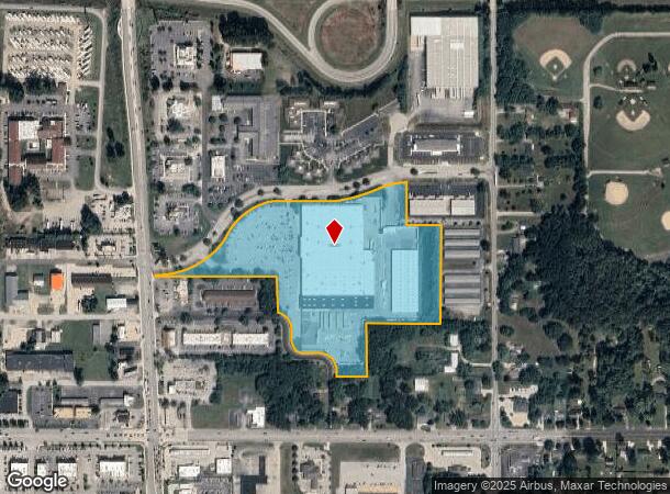
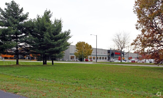
Property Record
601 E Windsor Ave, Elkhart, IN 46514

NEARBY LISTINGS FOR SALE OR LEASE
Property Detail
601 E Windsor Ave
20-02-20-476-021.000-027
MENARD PUD TRACT A (TIF 118)
Departmentstore
Elkhart
X
Indiana
18039C0126D
13
2024
17.99 AC
2025
Outlying Elkhart County
001601
South Bend/Mishawaka
196,080 SF
Elkhart-Goshen, IN
DEMOGRAPHICS near 601 E Windsor Ave
1 Mile
3 Mile
5 Mile
2024 Total Population
3,432
34,507
84,742
2029 Population
3,425
34,618
84,921
Pop Growth 2024-2029
(0.20%)
+ 0.32%
+ 0.21%
Average Age
39
39
38
2024 Total Households
1,519
14,195
32,144
HH Growth 2024-2029
(0.20%)
+ 0.42%
+ 0.22%
Median Household Inc
$50,399
$52,897
$54,320
Avg Household Size
2.30
2.40
2.50
2024 Avg HH Vehicles
2.00
2.00
2.00
Median Home Value
$152,166
$150,747
$155,133
Median Year Built
1985
1974
1972
Nearby Places
Map Layers
Map Styles
 Street
 Aerial
- Restaurants
- Banks
- Shops
- Fitness
- Groceries
PUBLIC TRANSPORTATION
COMMUTER RAIL
Elkhart Amtrak Station (Capitol Limited - Amtrak, Lake Shore Limited - Amtrak)
DRIVE
WALK
Distance
Elkhart Amtrak Station (Capitol Limited - Amtrak, Lake Shore Limited - Amtrak)
8 min
3.7 mi
AIRPORT
South Bend International
DRIVE
WALK
Distance
South Bend International
40 min
25.8 mi
Freight Ports
Port of Toledo
DRIVE
WALK
Distance
Port of Toledo
166 min
141.2 mi
Nearby Properties
Address
Land Use
TOTAL SIZE
Lot Size
Zoning
Address
Land Use
TOTAL SIZE
Lot Size
Zoning
373,218 SF
14.58 AC
ZO01
Address
Land Use
TOTAL SIZE
Lot Size
Zoning
384,095 SF
64.77 AC
Address
Land Use
TOTAL SIZE
Lot Size
Zoning
133,214 SF
0.30 AC
ZO01
Address
Land Use
TOTAL SIZE
Lot Size
Zoning
59,994 SF
46.12 AC
ZO01
Address
Land Use
TOTAL SIZE
Lot Size
Zoning
347,814 SF
27.57 AC
ZO01
Address
Land Use
TOTAL SIZE
Lot Size
Zoning
315,130 SF
6.54 AC
ZO01
Address
Land Use
TOTAL SIZE
Lot Size
Zoning
334,473 SF
24.88 AC
ZO01
Address
Land Use
TOTAL SIZE
Lot Size
Zoning
158,688 SF
20.79 AC
ZO01
Address
Land Use
TOTAL SIZE
Lot Size
Zoning
68,943 SF
20.40 AC
ZO01
Address
Land Use
TOTAL SIZE
Lot Size
Zoning
129,147 SF
3.23 AC
Address
Land Use
TOTAL SIZE
Lot Size
Zoning
70,800 SF
0.92 AC
ZO01
Address
Land Use
TOTAL SIZE
Lot Size
Zoning
128,225 SF
12.56 AC
ZO01
Address
Land Use
TOTAL SIZE
Lot Size
Zoning
203,685 SF
17.74 AC
ZO01
Address
Land Use
TOTAL SIZE
Lot Size
Zoning
244,703 SF
25.03 AC
ZO01
Address
Land Use
TOTAL SIZE
Lot Size
Zoning
78,006 SF
8.10 AC
ZO01
Address
Land Use
TOTAL SIZE
Lot Size
Zoning
204,010 SF
32.52 AC
ZO01
Address
Land Use
TOTAL SIZE
Lot Size
Zoning
198,093 SF
5.36 AC
ZO01
Address
Land Use
TOTAL SIZE
Lot Size
Zoning
279,045 SF
12.76 AC
ZO01
Address
Land Use
TOTAL SIZE
Lot Size
Zoning
246,553 SF
22.11 AC
ZO01
Address
Land Use
TOTAL SIZE
Lot Size
Zoning
81,452 SF
33.51 AC
ZO01
Address
Land Use
TOTAL SIZE
Lot Size
Zoning
65,387 SF
7.72 AC
ZO01
Address
Land Use
TOTAL SIZE
Lot Size
Zoning
142,932 SF
7.40 AC
ZO01
Address
Land Use
TOTAL SIZE
Lot Size
Zoning
164,420 SF
5.58 AC
ZO01
Address
Land Use
TOTAL SIZE
Lot Size
Zoning
147,726 SF
15.40 AC
ZO01
Address
Land Use
TOTAL SIZE
Lot Size
Zoning
43,839 SF
2.01 AC
ZO01
Address
Land Use
TOTAL SIZE
Lot Size
Zoning
139,274 SF
14.03 AC
ZO01
Address
Land Use
TOTAL SIZE
Lot Size
Zoning
425,363 SF
32.52 AC
ZO01
Address
Land Use
TOTAL SIZE
Lot Size
Zoning
153,910 SF
15.14 AC
Address
Land Use
TOTAL SIZE
Lot Size
Zoning
155,600 SF
10.53 AC
ZO01
The World's #1 Commercial Real Estate Marketplace
Connect with us
© 2026 CoStar Group
The information above has been obtained from sources believed reliable. While we do not doubt its accuracy we have not verified it and make no guarantee, warranty or representation about it. It is your responsibility to independently confirm its accuracy and completeness. Any projections, opinions, assumptions, or estimates used are for example only and do not represent the current or future performance of the property. The value of this transaction to you depends on tax and other factors which should be evaluated by your tax, financial, and legal advisors. You and your advisors should conduct a careful, independent investigation of the property to determine to your satisfaction the suitability of the property for your needs.