Property Record
601 Flarestar Ave, Columbus, OH 43240


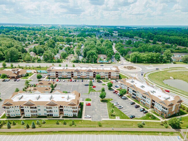
Property Detail
601 Flarestar Ave
318-344-01-012-000
LANDS 18 3 3 1 TIF AREA
Apartment
DELAWARE
B and X Area of moderate flood hazard, usually the area between the limits of the 100-year and 500-year floods.
Ohio
2024
11.54 AC
2024
Polaris South
012400
Columbus
132,804 SF
Columbus, OH
NEARBY LISTINGS FOR SALE OR LEASE
-
-
View all Columbus listings for sale on LoopNet.com
DEMOGRAPHICS near 601 Flarestar Ave
1 mile
3 mile
5 mile
2025 Total Population
19,423
83,747
235,532
2030 Population
20,488
87,701
245,284
Pop Growth 2025-2030
+ 5.48%
+ 4.72%
+ 4.14%
Average Age
35
37
39
2025 Total Households
8,404
33,994
92,767
HH Growth 2025-2030
+ 5.60%
+ 4.81%
+ 4.21%
Median Household Inc
$90,665
$101,385
$96,763
Avg Household Size
2.30
2.40
2.50
2025 Avg HH Vehicles
2.00
2.00
2.00
Median Home Value
$332,643
$380,347
$384,299
Median Year Built
1995
1992
1986
Nearby Places
Map Layers
Map Styles
 Street
 Aerial
Layers
 Traffic
 Biking
Places
Listings with unknown addresses are not visible on the map
- Restaurants
- Banks
- Shops
- Fitness
- Groceries
PUBLIC TRANSPORTATION
AIRPORT
John Glenn Columbus International
Drive
Walk
Distance
John Glenn Columbus International
25 min
17.3 mi
Rickenbacker International
Drive
Walk
Distance
Rickenbacker International
40 min
28.7 mi
Freight Ports
Port of Toledo
Drive
Walk
Distance
Port of Toledo
167 min
132.6 mi
Nearby Properties
Address
Land Use
TOTAL SIZE
Lot Size
Zoning
Address
Land Use
TOTAL SIZE
Lot Size
Zoning
635,036 SF
45.24 AC
Address
Land Use
TOTAL SIZE
Lot Size
Zoning
443,308 SF
9 AC
Address
Land Use
TOTAL SIZE
Lot Size
Zoning
2,140,832 SF
89.50 AC
Address
Land Use
TOTAL SIZE
Lot Size
Zoning
47,258 SF
50 AC
Address
Land Use
TOTAL SIZE
Lot Size
Zoning
206,724 SF
7.60 AC
Address
Land Use
TOTAL SIZE
Lot Size
Zoning
295,163 SF
16.04 AC
Address
Land Use
TOTAL SIZE
Lot Size
Zoning
171,631 SF
17.55 AC
Address
Land Use
TOTAL SIZE
Lot Size
Zoning
356,770 SF
2.65 AC
Address
Land Use
TOTAL SIZE
Lot Size
Zoning
271,562 SF
5.79 AC
Address
Land Use
TOTAL SIZE
Lot Size
Zoning
354,123 SF
19.81 AC
Address
Land Use
TOTAL SIZE
Lot Size
Zoning
217,722 SF
67.75 AC
Address
Land Use
TOTAL SIZE
Lot Size
Zoning
109,480 SF
17.86 AC
Address
Land Use
TOTAL SIZE
Lot Size
Zoning
577,104 SF
31.05 AC
Address
Land Use
TOTAL SIZE
Lot Size
Zoning
134,311 SF
17.26 AC
Address
Land Use
TOTAL SIZE
Lot Size
Zoning
62,852 SF
15.56 AC
Address
Land Use
TOTAL SIZE
Lot Size
Zoning
262,768 SF
4.35 AC
Address
Land Use
TOTAL SIZE
Lot Size
Zoning
249,917 SF
19.18 AC
Address
Land Use
TOTAL SIZE
Lot Size
Zoning
151,248 SF
13.30 AC
Address
Land Use
TOTAL SIZE
Lot Size
Zoning
38,976 SF
22.86 AC
Address
Land Use
TOTAL SIZE
Lot Size
Zoning
258,205 SF
5.13 AC
Address
Land Use
TOTAL SIZE
Lot Size
Zoning
266,792 SF
9.03 AC
Address
Land Use
TOTAL SIZE
Lot Size
Zoning
154,892 SF
5.86 AC
Address
Land Use
TOTAL SIZE
Lot Size
Zoning
413,781 SF
78.36 AC
Address
Land Use
TOTAL SIZE
Lot Size
Zoning
249,112 SF
5.94 AC
Address
Land Use
TOTAL SIZE
Lot Size
Zoning
119,213 SF
25.43 AC
Address
Land Use
TOTAL SIZE
Lot Size
Zoning
428,656 SF
6.42 AC
Address
Land Use
TOTAL SIZE
Lot Size
Zoning
70,648 SF
15.50 AC
Address
Land Use
TOTAL SIZE
Lot Size
Zoning
162,728 SF
4.80 AC
Address
Land Use
TOTAL SIZE
Lot Size
Zoning
187,562 SF
8.76 AC
Address
Land Use
TOTAL SIZE
Lot Size
Zoning
62,702 SF
38.69 AC
The World's #1 Commercial Real Estate Marketplace
Connect with us
© 2026 CoStar Group
The information above has been obtained from sources believed reliable. While we do not doubt its accuracy we have not verified it and make no guarantee, warranty or representation about it. It is your responsibility to independently confirm its accuracy and completeness. Any projections, opinions, assumptions, or estimates used are for example only and do not represent the current or future performance of the property. The value of this transaction to you depends on tax and other factors which should be evaluated by your tax, financial, and legal advisors. You and your advisors should conduct a careful, independent investigation of the property to determine to your satisfaction the suitability of the property for your needs.