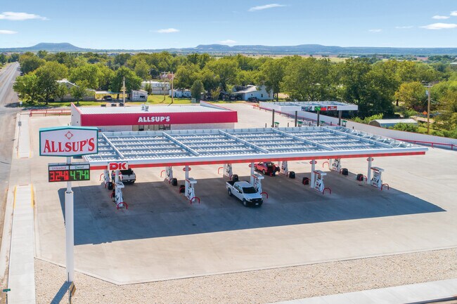
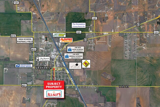
Property Record
601 Graham St, Tuscola, TX 79562
Property Detail
601 Graham St
Abilene, TX
ORIGINAL TOWN TUSCOLA, BLOCK 37, LOT E75 OF 13-15 & ALL 16-18, & N10 ABND N 5TH ST & 20 FT ALLEY
22793
Taylor
Agriculturalland
Texas
B and X Area of moderate flood hazard, usually the area between the limits of the 100-year and 500-year floods.
e75
2024
0.75 AC
2025
Abilene
013502
Other Market Areas
2,400 SF
NEARBY LISTINGS FOR SALE OR LEASE
-
-
View all Tuscola listings for sale on LoopNet.com
DEMOGRAPHICS near 601 Graham St
1 mile
3 mile
5 mile
2025 Total Population
1,356
2,558
4,892
2030 Population
1,421
2,686
5,132
Pop Growth 2025-2030
+ 4.79%
+ 5.00%
+ 4.91%
Average Age
40
40
40
2025 Total Households
486
925
1,754
HH Growth 2025-2030
+ 5.14%
+ 5.30%
+ 5.19%
Median Household Inc
$90,858
$88,931
$95,653
Avg Household Size
2.80
2.80
2.80
2025 Avg HH Vehicles
2.00
2.00
2.00
Median Home Value
$243,162
$235,929
$262,618
Median Year Built
1990
1987
1989
Nearby Places
Map Layers
Map Styles
 Street
 Aerial
Layers
 Traffic
 Biking
Places
Listings with unknown addresses are not visible on the map
- Restaurants
- Banks
- Shops
- Fitness
- Groceries
PUBLIC TRANSPORTATION
AIRPORT
Abilene Regional
Drive
Walk
Distance
Abilene Regional
27 min
20.6 mi
Freight Ports
Calhoun Port
Drive
Walk
Distance
Calhoun Port
420 min
360.0 mi
SALE & LEASE HISTORY
LISTING DATE
SALE/LEASE

Nov 04, 2022
For Sale
Nearby Properties
Address
Land Use
TOTAL SIZE
Lot Size
Zoning
Address
Land Use
TOTAL SIZE
Lot Size
Zoning
70,963 SF
62.86 AC
Address
Land Use
TOTAL SIZE
Lot Size
Zoning
11,632 SF
3.25 AC
Address
Land Use
TOTAL SIZE
Lot Size
Zoning
12,989 SF
1.95 AC
Address
Land Use
TOTAL SIZE
Lot Size
Zoning
24.18 AC
Address
Land Use
TOTAL SIZE
Lot Size
Zoning
23,400 SF
2.96 AC
Address
Land Use
TOTAL SIZE
Lot Size
Zoning
30,650 SF
4.07 AC
Address
Land Use
TOTAL SIZE
Lot Size
Zoning
5,659 SF
57.87 AC
Address
Land Use
TOTAL SIZE
Lot Size
Zoning
5,734 SF
0.86 AC
Address
Land Use
TOTAL SIZE
Lot Size
Zoning
8,784 SF
0.21 AC
Address
Land Use
TOTAL SIZE
Lot Size
Zoning
1,480 SF
11.37 AC
Address
Land Use
TOTAL SIZE
Lot Size
Zoning
9,310 SF
0.55 AC
Address
Land Use
TOTAL SIZE
Lot Size
Zoning
8,320 SF
0.90 AC
Address
Land Use
TOTAL SIZE
Lot Size
Zoning
20,100 SF
11.38 AC
Address
Land Use
TOTAL SIZE
Lot Size
Zoning
3,176 SF
0.72 AC
Address
Land Use
TOTAL SIZE
Lot Size
Zoning
23,194 SF
16.16 AC
Address
Land Use
TOTAL SIZE
Lot Size
Zoning
3,675 SF
0.30 AC
Address
Land Use
TOTAL SIZE
Lot Size
Zoning
6,600 SF
4.39 AC
Address
Land Use
TOTAL SIZE
Lot Size
Zoning
2,052 SF
0.32 AC
Address
Land Use
TOTAL SIZE
Lot Size
Zoning
2,800 SF
2.43 AC
Address
Land Use
TOTAL SIZE
Lot Size
Zoning
3,840 SF
1.60 AC
Address
Land Use
TOTAL SIZE
Lot Size
Zoning
2,320 SF
0.43 AC
Address
Land Use
TOTAL SIZE
Lot Size
Zoning
10,322 SF
3.45 AC
Address
Land Use
TOTAL SIZE
Lot Size
Zoning
4,850 SF
7.79 AC
Address
Land Use
TOTAL SIZE
Lot Size
Zoning
2,680 SF
154 AC
Address
Land Use
TOTAL SIZE
Lot Size
Zoning
1,600 SF
0.39 AC
Address
Land Use
TOTAL SIZE
Lot Size
Zoning
2,961 SF
0.58 AC
Address
Land Use
TOTAL SIZE
Lot Size
Zoning
7,551 SF
0.55 AC
Address
Land Use
TOTAL SIZE
Lot Size
Zoning
4,050 SF
0.16 AC
Address
Land Use
TOTAL SIZE
Lot Size
Zoning
10,580 SF
1.06 AC
The World's #1 Commercial Real Estate Marketplace
Connect with us
© 2026 CoStar Group
The information above has been obtained from sources believed reliable. While we do not doubt its accuracy we have not verified it and make no guarantee, warranty or representation about it. It is your responsibility to independently confirm its accuracy and completeness. Any projections, opinions, assumptions, or estimates used are for example only and do not represent the current or future performance of the property. The value of this transaction to you depends on tax and other factors which should be evaluated by your tax, financial, and legal advisors. You and your advisors should conduct a careful, independent investigation of the property to determine to your satisfaction the suitability of the property for your needs.