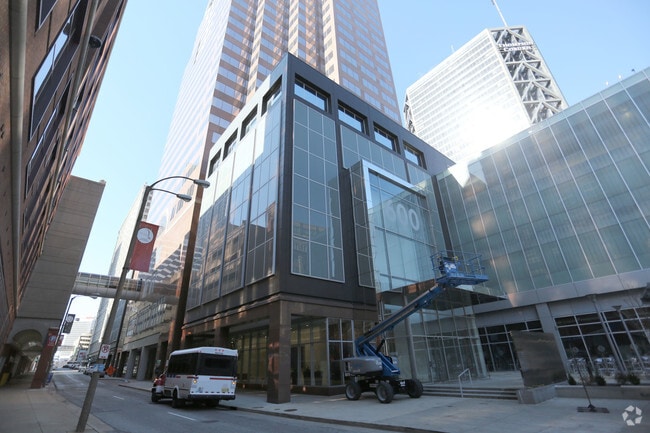
Property Record
601 Locust St, Saint Louis, MO 63101

NEARBY LISTINGS FOR SALE OR LEASE
Property Detail
601 Locust St
0127-00-0016-0
Lucass & Connors Addn
Commercialnec
C B 126 & 127 6TH ST ONE CITY CENTRE CONDOMINIUM UNIT 2 PT BLK 7 CONNORS ADDN & CHOUTEAU LUCAS ADDN
X
St. Louis City
2903850064C
Missouri
0
2.56 AC
2025
CBD
125600
St. Louis
540,266 SF
St. Louis, MO-IL
DEMOGRAPHICS near 601 Locust St
1 Mile
3 Mile
5 Mile
2024 Total Population
12,579
69,519
206,280
2029 Population
11,944
66,618
199,101
Pop Growth 2024-2029
(5.05%)
(4.17%)
(3.48%)
Average Age
37
38
39
2024 Total Households
7,465
33,700
96,039
HH Growth 2024-2029
(4.90%)
(4.30%)
(3.70%)
Median Household Inc
$57,481
$45,620
$45,277
Avg Household Size
1.50
1.90
2.00
2024 Avg HH Vehicles
1.00
1.00
1.00
Median Home Value
$186,412
$198,750
$147,873
Median Year Built
1949
1948
1948
Nearby Places
Map Layers
Map Styles
 Street
 Aerial
- Restaurants
- Banks
- Shops
- Fitness
- Groceries
PUBLIC TRANSPORTATION
TRANSIT/SUBWAY
Convention Center (Lambert Airport Shiloh-Scott - St. Louis MetroLink (MetroLink), Shrewsbury-Lansdowne I-44 Emerson Park - St. Louis MetroLink (MetroLink))
DRIVE
WALK
Distance
Convention Center (Lambert Airport Shiloh-Scott - St. Louis MetroLink (MetroLink), Shrewsbury-Lansdowne I-44 Emerson Park - St. Louis MetroLink (MetroLink))
3 min
0.2 mi
8th And Pine (Lambert Airport Shiloh-Scott - St. Louis MetroLink (MetroLink), Shrewsbury-Lansdowne I-44 Emerson Park - St. Louis MetroLink (MetroLink))
DRIVE
WALK
Distance
8th And Pine (Lambert Airport Shiloh-Scott - St. Louis MetroLink (MetroLink), Shrewsbury-Lansdowne I-44 Emerson Park - St. Louis MetroLink (MetroLink))
1 min
3 min
0.2 mi
Arch-Laclede's Landing (Lambert Airport Shiloh-Scott - St. Louis MetroLink (MetroLink), Shrewsbury-Lansdowne I-44 Emerson Park - St. Louis MetroLink (MetroLink))
DRIVE
WALK
Distance
Arch-Laclede's Landing (Lambert Airport Shiloh-Scott - St. Louis MetroLink (MetroLink), Shrewsbury-Lansdowne I-44 Emerson Park - St. Louis MetroLink (MetroLink))
2 min
9 min
0.5 mi
Stadium (Lambert Airport Shiloh-Scott - St. Louis MetroLink (MetroLink), Shrewsbury-Lansdowne I-44 Emerson Park - St. Louis MetroLink (MetroLink))
DRIVE
WALK
Distance
Stadium (Lambert Airport Shiloh-Scott - St. Louis MetroLink (MetroLink), Shrewsbury-Lansdowne I-44 Emerson Park - St. Louis MetroLink (MetroLink))
10 min
0.5 mi
East Riverfront (Lambert Airport Shiloh-Scott - St. Louis MetroLink (MetroLink), Shrewsbury-Lansdowne I-44 Emerson Park - St. Louis MetroLink (MetroLink))
DRIVE
WALK
Distance
East Riverfront (Lambert Airport Shiloh-Scott - St. Louis MetroLink (MetroLink), Shrewsbury-Lansdowne I-44 Emerson Park - St. Louis MetroLink (MetroLink))
12 min
0.6 mi
AIRPORT
St Louis Lambert International
DRIVE
WALK
Distance
St Louis Lambert International
16 min
14.2 mi
SALE & LEASE HISTORY
LISTING DATE
SALE/LEASE

Sep 25, 2016
For Lease
Nearby Properties
Address
Land Use
TOTAL SIZE
Lot Size
Zoning
Address
Land Use
TOTAL SIZE
Lot Size
Zoning
467,000 SF
11.19 AC
I
Address
Land Use
TOTAL SIZE
Lot Size
Zoning
1,037,632 SF
3.34 AC
I
Address
Land Use
TOTAL SIZE
Lot Size
Zoning
661,472 SF
7.29 AC
L
Address
Land Use
TOTAL SIZE
Lot Size
Zoning
1.72 AC
I
Address
Land Use
TOTAL SIZE
Lot Size
Zoning
1.71 AC
I
Address
Land Use
TOTAL SIZE
Lot Size
Zoning
355,000 SF
0.75 AC
I
Address
Land Use
TOTAL SIZE
Lot Size
Zoning
472,328 SF
19.85 AC
I
Address
Land Use
TOTAL SIZE
Lot Size
Zoning
10.97 AC
I
Address
Land Use
TOTAL SIZE
Lot Size
Zoning
1,165,128 SF
1.70 AC
L
Address
Land Use
TOTAL SIZE
Lot Size
Zoning
624,049 SF
20.78 AC
K
Address
Land Use
TOTAL SIZE
Lot Size
Zoning
1,189,932 SF
1.45 AC
I
Address
Land Use
TOTAL SIZE
Lot Size
Zoning
7.38 AC
I
Address
Land Use
TOTAL SIZE
Lot Size
Zoning
1,089,750 SF
8.43 AC
I
Address
Land Use
TOTAL SIZE
Lot Size
Zoning
593,701 SF
2.08 AC
I
Address
Land Use
TOTAL SIZE
Lot Size
Zoning
246,345 SF
4.17 AC
J
Address
Land Use
TOTAL SIZE
Lot Size
Zoning
1.98 AC
H
Address
Land Use
TOTAL SIZE
Lot Size
Zoning
Address
Land Use
TOTAL SIZE
Lot Size
Zoning
423,303 SF
9.97 AC
H
Address
Land Use
TOTAL SIZE
Lot Size
Zoning
702,704 SF
2.10 AC
I
Address
Land Use
TOTAL SIZE
Lot Size
Zoning
360,580 SF
26.13 AC
KJ
Address
Land Use
TOTAL SIZE
Lot Size
Zoning
570,135 SF
0.52 AC
I
Address
Land Use
TOTAL SIZE
Lot Size
Zoning
359,040 SF
1.33 AC
L
Address
Land Use
TOTAL SIZE
Lot Size
Zoning
439,346 SF
1.45 AC
I
Address
Land Use
TOTAL SIZE
Lot Size
Zoning
303,680 SF
2.09 AC
I
Address
Land Use
TOTAL SIZE
Lot Size
Zoning
190,000 SF
2.71 AC
I
Address
Land Use
TOTAL SIZE
Lot Size
Zoning
192,892 SF
4.44 AC
I
Address
Land Use
TOTAL SIZE
Lot Size
Zoning
8.54 AC
H
Address
Land Use
TOTAL SIZE
Lot Size
Zoning
15.11 AC
I
Address
Land Use
TOTAL SIZE
Lot Size
Zoning
413,353 SF
2.56 AC
L
Address
Land Use
TOTAL SIZE
Lot Size
Zoning
870,868 SF
1.53 AC
I
The World's #1 Commercial Real Estate Marketplace
Connect with us
© 2025 CoStar Group
The information above has been obtained from sources believed reliable. While we do not doubt its accuracy we have not verified it and make no guarantee, warranty or representation about it. It is your responsibility to independently confirm its accuracy and completeness. Any projections, opinions, assumptions, or estimates used are for example only and do not represent the current or future performance of the property. The value of this transaction to you depends on tax and other factors which should be evaluated by your tax, financial, and legal advisors. You and your advisors should conduct a careful, independent investigation of the property to determine to your satisfaction the suitability of the property for your needs.