Property Record
601 Main St, Dunedin, FL 34698

NEARBY LISTINGS FOR SALE OR LEASE
-
-
View all Dunedin listings for sale on LoopNet.com
Property Detail
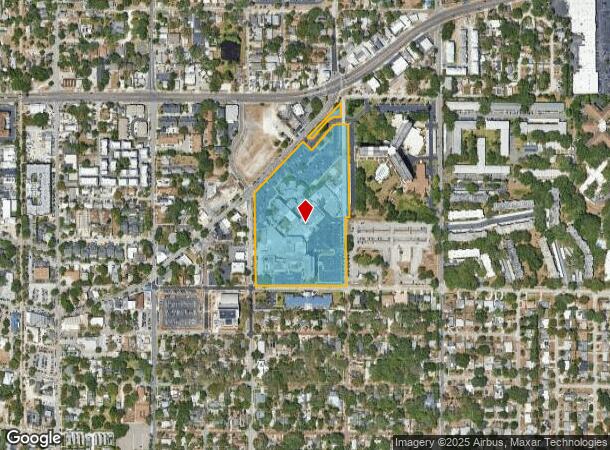
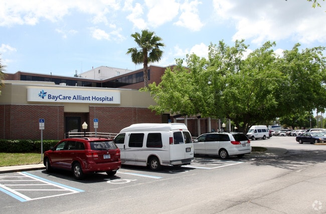
601 Main St
27-28-15-00000-440-0300
Com At Se Cor Of Sw 1/4 Of
Hospitalpublic
COM AT SE COR OF SW 1/4 OF SE 1/4 OF SE 1/4 RUN N 30 FT FOR POB TH CONT N 467.87FT TH E 25FT TH N 640.59FT TH W 50FT TH N 146.06FT TH SWLY ALG S R/W LN OF MAIN ST 880FT (S) TH S 615FT (S) TH E 615.11FT TO POB LESS RD R/W LYING WITHIN CONT 13.57AC(C)
X
Pinellas
12103C0068H
Florida
2024
13.80 AC
2025
North Pinellas
027108
Tampa/St Petersburg
362,238 SF
Tampa-St. Petersburg-Clearwater, FL
DEMOGRAPHICS near 601 Main St
1 Mile
3 Mile
5 Mile
2024 Total Population
13,274
76,957
188,817
2029 Population
13,511
77,524
189,607
Pop Growth 2024-2029
+ 1.79%
+ 0.74%
+ 0.42%
Average Age
52
49
47
2024 Total Households
6,927
36,321
85,747
HH Growth 2024-2029
+ 1.76%
+ 0.63%
+ 0.38%
Median Household Inc
$51,136
$55,196
$58,495
Avg Household Size
1.80
2.00
2.10
2024 Avg HH Vehicles
1.00
1.00
2.00
Median Home Value
$269,967
$274,073
$291,386
Median Year Built
1970
1975
1977
Nearby Places
Map Layers
Map Styles
 Street
 Aerial
- Restaurants
- Banks
- Shops
- Fitness
- Groceries
PUBLIC TRANSPORTATION
AIRPORT
St Pete-Clearwater International
DRIVE
WALK
Distance
St Pete-Clearwater International
32 min
16.8 mi
Tampa International
DRIVE
WALK
Distance
Tampa International
35 min
21.0 mi
Freight Ports
Port of Tampa Bay
DRIVE
WALK
Distance
Port of Tampa Bay
49 min
29.4 mi
Nearby Properties
Address
Land Use
TOTAL SIZE
Lot Size
Zoning
Address
Land Use
TOTAL SIZE
Lot Size
Zoning
675,202 SF
43.24 AC
Address
Land Use
TOTAL SIZE
Lot Size
Zoning
724,220 SF
22.95 AC
Address
Land Use
TOTAL SIZE
Lot Size
Zoning
460,041 SF
44.28 AC
Address
Land Use
TOTAL SIZE
Lot Size
Zoning
167,201 SF
63.11 AC
AE
Address
Land Use
TOTAL SIZE
Lot Size
Zoning
406,729 SF
29.79 AC
CP1
Address
Land Use
TOTAL SIZE
Lot Size
Zoning
412,099 SF
49.21 AC
Address
Land Use
TOTAL SIZE
Lot Size
Zoning
278,505 SF
38.67 AC
Address
Land Use
TOTAL SIZE
Lot Size
Zoning
4,250 SF
235.09 AC
Address
Land Use
TOTAL SIZE
Lot Size
Zoning
367,503 SF
20.34 AC
M2
Address
Land Use
TOTAL SIZE
Lot Size
Zoning
117,024 SF
56.52 AC
Address
Land Use
TOTAL SIZE
Lot Size
Zoning
241,170 SF
17.23 AC
Address
Land Use
TOTAL SIZE
Lot Size
Zoning
151,730 SF
49.66 AC
Address
Land Use
TOTAL SIZE
Lot Size
Zoning
191,375 SF
13.58 AC
AE
Address
Land Use
TOTAL SIZE
Lot Size
Zoning
250,113 SF
39.50 AC
Address
Land Use
TOTAL SIZE
Lot Size
Zoning
196,808 SF
12.70 AC
Address
Land Use
TOTAL SIZE
Lot Size
Zoning
7,504 SF
1.71 AC
Address
Land Use
TOTAL SIZE
Lot Size
Zoning
1.51 AC
Address
Land Use
TOTAL SIZE
Lot Size
Zoning
220,640 SF
9.02 AC
Address
Land Use
TOTAL SIZE
Lot Size
Zoning
201,208 SF
2.16 AC
Address
Land Use
TOTAL SIZE
Lot Size
Zoning
228,493 SF
21.21 AC
Address
Land Use
TOTAL SIZE
Lot Size
Zoning
173,160 SF
5.39 AC
Address
Land Use
TOTAL SIZE
Lot Size
Zoning
107,766 SF
25.15 AC
Address
Land Use
TOTAL SIZE
Lot Size
Zoning
158,400 SF
9.80 AC
Address
Land Use
TOTAL SIZE
Lot Size
Zoning
396,841 SF
9.73 AC
Address
Land Use
TOTAL SIZE
Lot Size
Zoning
415,593 SF
29.66 AC
Address
Land Use
TOTAL SIZE
Lot Size
Zoning
6,296 SF
1.03 AC
Address
Land Use
TOTAL SIZE
Lot Size
Zoning
236,952 SF
14.48 AC
Address
Land Use
TOTAL SIZE
Lot Size
Zoning
116,557 SF
12.57 AC
R4
Address
Land Use
TOTAL SIZE
Lot Size
Zoning
14,344 SF
7.89 AC
The World's #1 Commercial Real Estate Marketplace
Connect with us
© 2026 CoStar Group
The information above has been obtained from sources believed reliable. While we do not doubt its accuracy we have not verified it and make no guarantee, warranty or representation about it. It is your responsibility to independently confirm its accuracy and completeness. Any projections, opinions, assumptions, or estimates used are for example only and do not represent the current or future performance of the property. The value of this transaction to you depends on tax and other factors which should be evaluated by your tax, financial, and legal advisors. You and your advisors should conduct a careful, independent investigation of the property to determine to your satisfaction the suitability of the property for your needs.