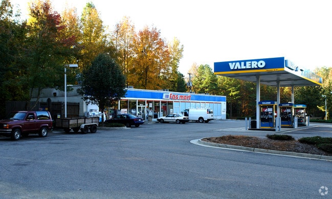
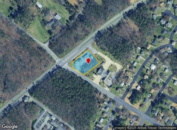
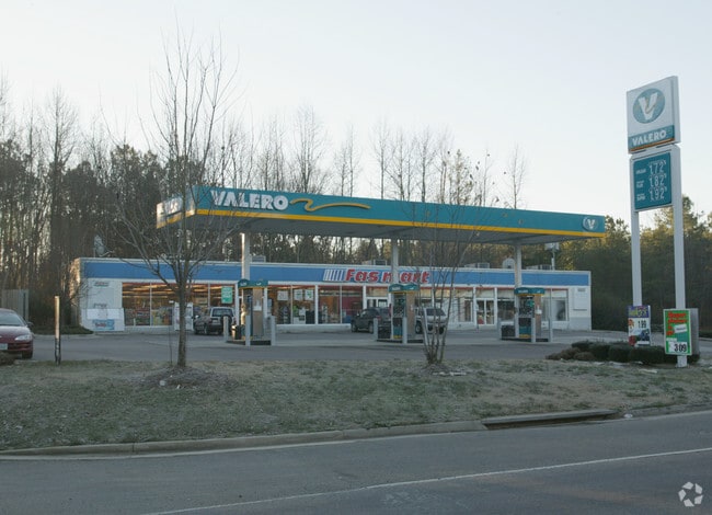
Property Record
601 N Airport Dr, Henrico, VA 23075
NEARBY LISTINGS FOR SALE OR LEASE
Property Detail
601 N Airport Dr
828-723-1981
01490A0000 0011A; AIRPORT DR & E WASH AC 1.0136 14 B1 44
Conveniencestore
Henrico
X
Virginia
51085C0445C
1.01 AC
2025
East End
2025
Richmond VA
201403
Richmond, VA
4,288 SF
DEMOGRAPHICS near 601 N Airport Dr
1 Mile
3 Mile
5 Mile
2024 Total Population
5,944
27,614
70,474
2029 Population
5,906
27,459
71,424
Pop Growth 2024-2029
(0.64%)
(0.56%)
+ 1.35%
Average Age
39
39
40
2024 Total Households
2,326
11,047
28,520
HH Growth 2024-2029
(0.73%)
(0.57%)
+ 1.32%
Median Household Inc
$55,465
$56,680
$59,853
Avg Household Size
2.50
2.50
2.40
2024 Avg HH Vehicles
2.00
2.00
2.00
Median Home Value
$161,296
$170,249
$202,529
Median Year Built
1978
1977
1980
Nearby Places
- Restaurants
- Banks
- Shops
- Fitness
- Groceries
PUBLIC TRANSPORTATION
COMMUTER RAIL
DRIVE
WALK
Distance
13 min
8.3 mi
AIRPORT
Richmond International
DRIVE
WALK
Distance
Richmond International
9 min
3.7 mi
Freight Ports
Virginia Port Authority - Richmond
DRIVE
WALK
Distance
Virginia Port Authority - Richmond
24 min
13.9 mi
Nearby Properties
Address
Land Use
TOTAL SIZE
Lot Size
Zoning
Address
Land Use
TOTAL SIZE
Lot Size
Zoning
548,680 SF
2,298.89 AC
MIXE
Address
Land Use
TOTAL SIZE
Lot Size
Zoning
143,287 SF
56.39 AC
MIXE
Address
Land Use
TOTAL SIZE
Lot Size
Zoning
60,032 SF
62 AC
B-3C
Address
Land Use
TOTAL SIZE
Lot Size
Zoning
522,399 SF
58.07 AC
M-1
Address
Land Use
TOTAL SIZE
Lot Size
Zoning
322,000 SF
15.94 AC
M-1
Address
Land Use
TOTAL SIZE
Lot Size
Zoning
181,200 SF
14.74 AC
R-5
Address
Land Use
TOTAL SIZE
Lot Size
Zoning
146,560 SF
11.09 AC
R-5
Address
Land Use
TOTAL SIZE
Lot Size
Zoning
15,680 SF
39.75 AC
R-3
Address
Land Use
TOTAL SIZE
Lot Size
Zoning
108,738 SF
6.39 AC
R-6
Address
Land Use
TOTAL SIZE
Lot Size
Zoning
91,642 SF
45.95 AC
A-1
Address
Land Use
TOTAL SIZE
Lot Size
Zoning
142,379 SF
17.69 AC
M-1
Address
Land Use
TOTAL SIZE
Lot Size
Zoning
137,051 SF
16.39 AC
B-3C
Address
Land Use
TOTAL SIZE
Lot Size
Zoning
69,248 SF
5.24 AC
B-3C
Address
Land Use
TOTAL SIZE
Lot Size
Zoning
53,530 SF
4.50 AC
M-1C
Address
Land Use
TOTAL SIZE
Lot Size
Zoning
144,135 SF
9.72 AC
M-1
Address
Land Use
TOTAL SIZE
Lot Size
Zoning
127,868 SF
12.85 AC
B-3C
Address
Land Use
TOTAL SIZE
Lot Size
Zoning
9.66 AC
R-5
Address
Land Use
TOTAL SIZE
Lot Size
Zoning
156,390 SF
13.37 AC
B-3C
Address
Land Use
TOTAL SIZE
Lot Size
Zoning
63,700 SF
19.50 AC
A-1
Address
Land Use
TOTAL SIZE
Lot Size
Zoning
130,638 SF
11.06 AC
R-5
Address
Land Use
TOTAL SIZE
Lot Size
Zoning
1,546 SF
43.18 AC
MIXE
Address
Land Use
TOTAL SIZE
Lot Size
Zoning
155,268 SF
11.50 AC
R-5
Address
Land Use
TOTAL SIZE
Lot Size
Zoning
149,544 SF
12.49 AC
R-5
Address
Land Use
TOTAL SIZE
Lot Size
Zoning
87,384 SF
8.05 AC
R-5
Address
Land Use
TOTAL SIZE
Lot Size
Zoning
109,728 SF
9.09 AC
R-5C
Address
Land Use
TOTAL SIZE
Lot Size
Zoning
110,915 SF
8.58 AC
B-3C
Address
Land Use
TOTAL SIZE
Lot Size
Zoning
80,815 SF
3.25 AC
M-1
Address
Land Use
TOTAL SIZE
Lot Size
Zoning
42,755 SF
103.73 AC
M-1
Address
Land Use
TOTAL SIZE
Lot Size
Zoning
100,240 SF
7.81 AC
R-5
Address
Land Use
TOTAL SIZE
Lot Size
Zoning
93,340 SF
3.21 AC
B-3C
The World's #1 Commercial Real Estate Marketplace
Connect with us
© 2025 CoStar Group
The information above has been obtained from sources believed reliable. While we do not doubt its accuracy we have not verified it and make no guarantee, warranty or representation about it. It is your responsibility to independently confirm its accuracy and completeness. Any projections, opinions, assumptions, or estimates used are for example only and do not represent the current or future performance of the property. The value of this transaction to you depends on tax and other factors which should be evaluated by your tax, financial, and legal advisors. You and your advisors should conduct a careful, independent investigation of the property to determine to your satisfaction the suitability of the property for your needs.