Property Record
601 Nw River Rd, Martindale, TX 78655


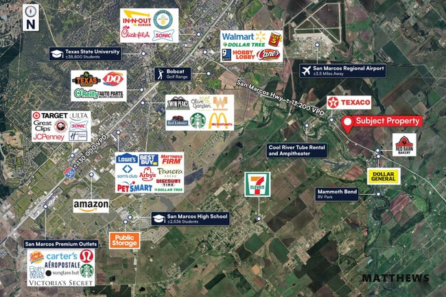
This Property Is For Sale
Property Detail
601 Nw River Rd
27897
A021 PETTUS, WILLIAM, ACRES 23.982
Farms
Caldwell
AE The base floodplain where base flood elevations are provided. AE Zones are now used on new format FIRMs instead of A1-A30 Zones.
Texas
2025
23.98 AC
2025
Caldwell County
960501
Austin
961 SF
Austin-Round Rock-San Marcos, TX
NEARBY LISTINGS FOR SALE OR LEASE
DEMOGRAPHICS near 601 Nw River Rd
1 mile
3 mile
5 mile
2025 Total Population
1,435
6,201
43,770
2030 Population
1,584
6,912
49,929
Pop Growth 2025-2030
+ 10.38%
+ 11.47%
+ 14.07%
Average Age
39
34
33
2025 Total Households
492
1,664
17,034
HH Growth 2025-2030
+ 11.18%
+ 13.16%
+ 14.91%
Median Household Inc
$45,463
$55,200
$52,359
Avg Household Size
2.90
2.70
2.40
2025 Avg HH Vehicles
3.00
2.00
2.00
Median Home Value
$270,289
$258,012
$191,623
Median Year Built
1992
1994
1999
Nearby Places
Map Layers
Map Styles
 Street
 Aerial
Transit
 Traffic
 Biking
Places
Listings with unknown addresses are not visible on the map
- Restaurants
- Banks
- Shops
- Fitness
- Groceries
PUBLIC TRANSPORTATION
COMMUTER RAIL
San Marcos Amtrak (Texas Eagle - Amtrak)
Drive
Walk
Distance
San Marcos Amtrak (Texas Eagle - Amtrak)
11 min
6.4 mi
AIRPORT
Austin-Bergstrom International
Drive
Walk
Distance
Austin-Bergstrom International
43 min
34.2 mi
Freight Ports
Calhoun Port
Drive
Walk
Distance
Calhoun Port
156 min
129.6 mi
Nearby Properties
Address
Land Use
TOTAL SIZE
Lot Size
Zoning
Address
Land Use
TOTAL SIZE
Lot Size
Zoning
13,158 SF
457.48 AC
Address
Land Use
TOTAL SIZE
Lot Size
Zoning
2,375 SF
10.48 AC
Address
Land Use
TOTAL SIZE
Lot Size
Zoning
299.60 AC
Address
Land Use
TOTAL SIZE
Lot Size
Zoning
1,250 SF
219.53 AC
Address
Land Use
TOTAL SIZE
Lot Size
Zoning
58,600 SF
1.35 AC
Address
Land Use
TOTAL SIZE
Lot Size
Zoning
300.96 AC
Address
Land Use
TOTAL SIZE
Lot Size
Zoning
337.93 AC
Address
Land Use
TOTAL SIZE
Lot Size
Zoning
29,570 SF
0.57 AC
Address
Land Use
TOTAL SIZE
Lot Size
Zoning
196.33 AC
Address
Land Use
TOTAL SIZE
Lot Size
Zoning
301.75 AC
Address
Land Use
TOTAL SIZE
Lot Size
Zoning
1,920 SF
19.11 AC
Address
Land Use
TOTAL SIZE
Lot Size
Zoning
4,685 SF
112.43 AC
Address
Land Use
TOTAL SIZE
Lot Size
Zoning
149.40 AC
Address
Land Use
TOTAL SIZE
Lot Size
Zoning
81.09 AC
Address
Land Use
TOTAL SIZE
Lot Size
Zoning
253.25 AC
Address
Land Use
TOTAL SIZE
Lot Size
Zoning
8,785 SF
9.78 AC
Address
Land Use
TOTAL SIZE
Lot Size
Zoning
3,150 SF
1.51 AC
Address
Land Use
TOTAL SIZE
Lot Size
Zoning
31,640 SF
1.36 AC
Address
Land Use
TOTAL SIZE
Lot Size
Zoning
4,157 SF
75.53 AC
Address
Land Use
TOTAL SIZE
Lot Size
Zoning
1,000 SF
90.76 AC
Address
Land Use
TOTAL SIZE
Lot Size
Zoning
Address
Land Use
TOTAL SIZE
Lot Size
Zoning
1,420 SF
4.34 AC
Address
Land Use
TOTAL SIZE
Lot Size
Zoning
2,582 SF
50.06 AC
Address
Land Use
TOTAL SIZE
Lot Size
Zoning
107.25 AC
Address
Land Use
TOTAL SIZE
Lot Size
Zoning
36.99 AC
Address
Land Use
TOTAL SIZE
Lot Size
Zoning
103.70 AC
Address
Land Use
TOTAL SIZE
Lot Size
Zoning
754 SF
71.66 AC
Address
Land Use
TOTAL SIZE
Lot Size
Zoning
11,768 SF
0.26 AC
Address
Land Use
TOTAL SIZE
Lot Size
Zoning
127.80 AC
Address
Land Use
TOTAL SIZE
Lot Size
Zoning
134.84 AC
The World's #1 Commercial Real Estate Marketplace
Connect with us
© 2026 CoStar Group
The information above has been obtained from sources believed reliable. While we do not doubt its accuracy we have not verified it and make no guarantee, warranty or representation about it. It is your responsibility to independently confirm its accuracy and completeness. Any projections, opinions, assumptions, or estimates used are for example only and do not represent the current or future performance of the property. The value of this transaction to you depends on tax and other factors which should be evaluated by your tax, financial, and legal advisors. You and your advisors should conduct a careful, independent investigation of the property to determine to your satisfaction the suitability of the property for your needs.