Property Record
601 Oneida St, Chittenango, NY 13037
NEARBY LISTINGS FOR SALE OR LEASE
-
-
View all Chittenango listings for sale on LoopNet.com
Property Detail
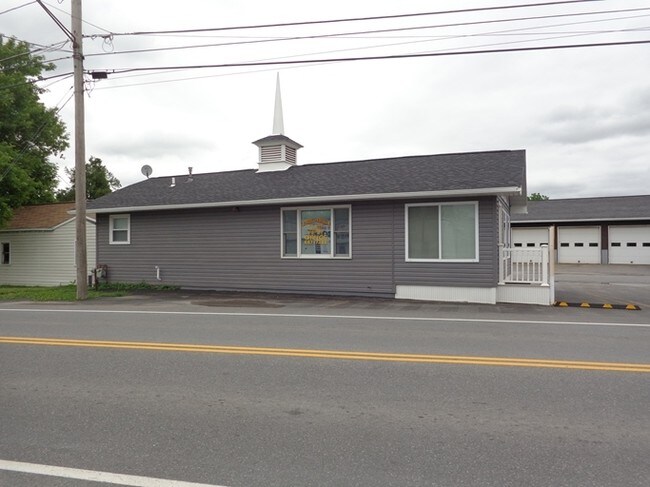
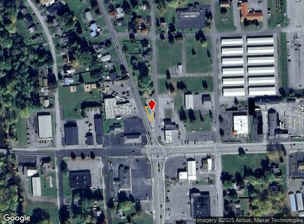
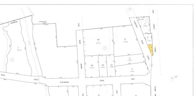
601 Oneida St
Syracuse, NY
MCNALLY'S PUB
254801-041-073-0001-009-000-0000
Madison
Storesoffices
New York
2025
9.000
2024
0.04 AC
030401
Madison County
792 SF
Syracuse
DEMOGRAPHICS near 601 Oneida St
1 Mile
3 Mile
5 Mile
2024 Total Population
2,615
7,666
12,411
2029 Population
2,562
7,532
12,252
Pop Growth 2024-2029
(2.03%)
(1.75%)
(1.28%)
Average Age
43
43
43
2024 Total Households
1,082
3,117
5,049
HH Growth 2024-2029
(2.22%)
(1.92%)
(1.45%)
Median Household Inc
$79,605
$83,580
$86,876
Avg Household Size
2.40
2.40
2.40
2024 Avg HH Vehicles
2.00
2.00
2.00
Median Home Value
$199,473
$209,357
$204,995
Median Year Built
1966
1973
1975
Nearby Places
Map Layers
Map Styles
 Street
 Aerial
- Restaurants
- Banks
- Shops
- Fitness
- Groceries
PUBLIC TRANSPORTATION
AIRPORT
Syracuse Hancock International
DRIVE
WALK
Distance
Syracuse Hancock International
38 min
21.5 mi
Nearby Properties
Address
Land Use
TOTAL SIZE
Lot Size
Zoning
Address
Land Use
TOTAL SIZE
Lot Size
Zoning
103,497 SF
23.96 AC
RES
Address
Land Use
TOTAL SIZE
Lot Size
Zoning
129,797 SF
Address
Land Use
TOTAL SIZE
Lot Size
Zoning
17,770 SF
47.91 AC
Address
Land Use
TOTAL SIZE
Lot Size
Zoning
68,425 SF
40.93 AC
Address
Land Use
TOTAL SIZE
Lot Size
Zoning
25,225 SF
47.07 AC
AG
Address
Land Use
TOTAL SIZE
Lot Size
Zoning
Address
Land Use
TOTAL SIZE
Lot Size
Zoning
42,307 SF
5.20 AC
02 - SINGL
Address
Land Use
TOTAL SIZE
Lot Size
Zoning
124,302 SF
11.44 AC
05 - COMME
Address
Land Use
TOTAL SIZE
Lot Size
Zoning
432 SF
7.28 AC
Address
Land Use
TOTAL SIZE
Lot Size
Zoning
Address
Land Use
TOTAL SIZE
Lot Size
Zoning
980 SF
0.99 AC
AG
Address
Land Use
TOTAL SIZE
Lot Size
Zoning
5,284 SF
3.90 AC
AG
Address
Land Use
TOTAL SIZE
Lot Size
Zoning
86,853 SF
22.01 AC
Address
Land Use
TOTAL SIZE
Lot Size
Zoning
1,512 SF
57.29 AC
RA
Address
Land Use
TOTAL SIZE
Lot Size
Zoning
10,920 SF
3.38 AC
03 - MULTI
Address
Land Use
TOTAL SIZE
Lot Size
Zoning
10,824 SF
37.34 AC
CB
Address
Land Use
TOTAL SIZE
Lot Size
Zoning
5,700 SF
0.95 AC
Address
Land Use
TOTAL SIZE
Lot Size
Zoning
6,600 SF
1.23 AC
Address
Land Use
TOTAL SIZE
Lot Size
Zoning
6,000 SF
2.68 AC
Address
Land Use
TOTAL SIZE
Lot Size
Zoning
13,259 SF
1.52 AC
05 - COMME
Address
Land Use
TOTAL SIZE
Lot Size
Zoning
6,844 SF
0.22 AC
AG
Address
Land Use
TOTAL SIZE
Lot Size
Zoning
12,646 SF
3.15 AC
03 - MULTI
Address
Land Use
TOTAL SIZE
Lot Size
Zoning
9,239 SF
30.58 AC
04 - FARM
Address
Land Use
TOTAL SIZE
Lot Size
Zoning
25.54 AC
Address
Land Use
TOTAL SIZE
Lot Size
Zoning
6,141 SF
3.96 AC
APT
Address
Land Use
TOTAL SIZE
Lot Size
Zoning
3,600 SF
3.34 AC
05 - COMME
Address
Land Use
TOTAL SIZE
Lot Size
Zoning
7,987 SF
0.78 AC
BUS
Address
Land Use
TOTAL SIZE
Lot Size
Zoning
6,177 SF
2.37 AC
05 - COMME
Address
Land Use
TOTAL SIZE
Lot Size
Zoning
2,936 SF
2.93 AC
05 - COMME
Address
Land Use
TOTAL SIZE
Lot Size
Zoning
9,000 SF
1.41 AC
AG
The World's #1 Commercial Real Estate Marketplace
Connect with us
© 2026 CoStar Group
The information above has been obtained from sources believed reliable. While we do not doubt its accuracy we have not verified it and make no guarantee, warranty or representation about it. It is your responsibility to independently confirm its accuracy and completeness. Any projections, opinions, assumptions, or estimates used are for example only and do not represent the current or future performance of the property. The value of this transaction to you depends on tax and other factors which should be evaluated by your tax, financial, and legal advisors. You and your advisors should conduct a careful, independent investigation of the property to determine to your satisfaction the suitability of the property for your needs.