Property Record
601 Pendleton St, Waycross, GA 31501

Save to a Folder
{{folder.Name}}
{{folder.ListingIds.length}} Properties
{{folder.ListingIds.length}} Property
Create a New Folder
Current Lease Availabilities
Property Detail
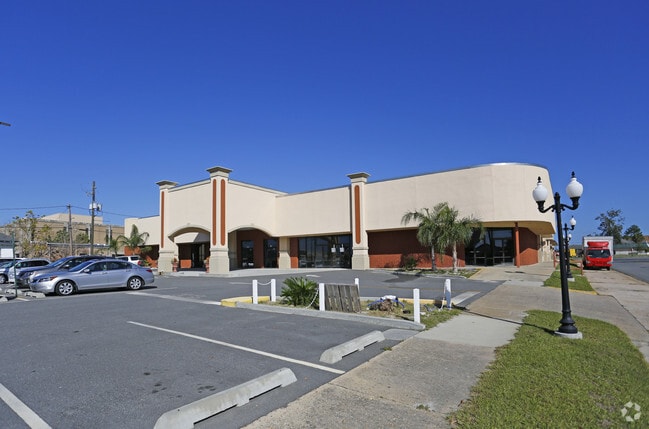
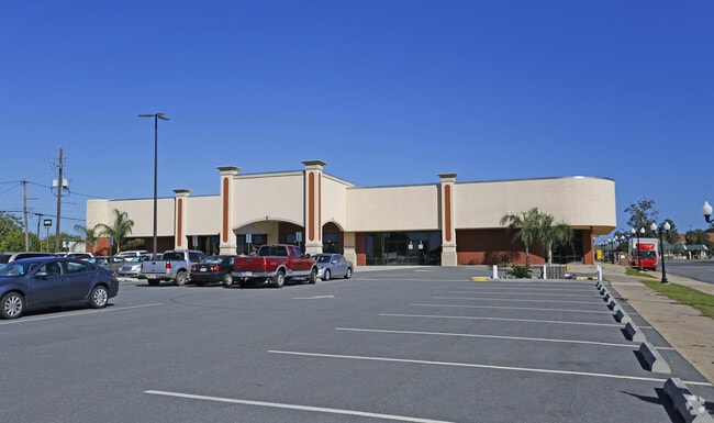
601 Pendleton St
WA0904-039
PENDLETON ST 601-615 B16 LG-N
Medicalbuilding
WARE
005
Georgia
B and X Area of moderate flood hazard, usually the area between the limits of the 100-year and 500-year floods.
1.73 AC
2025
Georgia South Area
2025
Other Market Areas
950500
Waycross, GA
30,191 SF
NEARBY LISTINGS FOR SALE OR LEASE
DEMOGRAPHICS near 601 Pendleton St
1 mile
3 mile
5 mile
2025 Total Population
6,131
22,747
30,243
2030 Population
6,377
23,005
30,607
Pop Growth 2025-2030
+ 4.01%
+ 1.13%
+ 1.20%
Average Age
38
40
40
2025 Total Households
2,381
9,004
11,793
HH Growth 2025-2030
+ 3.99%
+ 1.11%
+ 1.18%
Median Household Inc
$29,931
$40,429
$43,523
Avg Household Size
2.50
2.40
2.50
2025 Avg HH Vehicles
1.00
1.00
2.00
Median Home Value
$63,184
$94,401
$114,567
Median Year Built
1963
1972
1976
Nearby Places
Map Layers
Map Styles
 Street
 Aerial
Layers
 Traffic
 Biking
Places
Listings with unknown addresses are not visible on the map
- Restaurants
- Banks
- Shops
- Fitness
- Groceries
Nearby Properties
Address
Land Use
TOTAL SIZE
Lot Size
Zoning
Address
Land Use
TOTAL SIZE
Lot Size
Zoning
3,880 SF
141.42 AC
005
Address
Land Use
TOTAL SIZE
Lot Size
Zoning
71.65 AC
006
Address
Land Use
TOTAL SIZE
Lot Size
Zoning
21,671 SF
116.27 AC
005
Address
Land Use
TOTAL SIZE
Lot Size
Zoning
64,745 SF
13.49 AC
001
Address
Land Use
TOTAL SIZE
Lot Size
Zoning
5,474 SF
5.18 AC
005
Address
Land Use
TOTAL SIZE
Lot Size
Zoning
91,611 SF
76.30 AC
006
Address
Land Use
TOTAL SIZE
Lot Size
Zoning
120,700 SF
22.70 AC
001
Address
Land Use
TOTAL SIZE
Lot Size
Zoning
260,001 SF
14.28 AC
009
Address
Land Use
TOTAL SIZE
Lot Size
Zoning
205,040 SF
19.22 AC
002
Address
Land Use
TOTAL SIZE
Lot Size
Zoning
52,943 SF
155.98 AC
006
Address
Land Use
TOTAL SIZE
Lot Size
Zoning
3,250 SF
7.25 AC
005
Address
Land Use
TOTAL SIZE
Lot Size
Zoning
74,500 SF
24.83 AC
006
Address
Land Use
TOTAL SIZE
Lot Size
Zoning
145,392 SF
26.93 AC
002
Address
Land Use
TOTAL SIZE
Lot Size
Zoning
74,232 SF
13.77 AC
005
Address
Land Use
TOTAL SIZE
Lot Size
Zoning
46,296 SF
16 AC
006
Address
Land Use
TOTAL SIZE
Lot Size
Zoning
36,654 SF
7.50 AC
005
Address
Land Use
TOTAL SIZE
Lot Size
Zoning
61,026 SF
8 AC
006
Address
Land Use
TOTAL SIZE
Lot Size
Zoning
86,525 SF
10.46 AC
002
Address
Land Use
TOTAL SIZE
Lot Size
Zoning
286,172 SF
31.62 AC
002
Address
Land Use
TOTAL SIZE
Lot Size
Zoning
35,439 SF
3.05 AC
005
Address
Land Use
TOTAL SIZE
Lot Size
Zoning
37,800 SF
3.93 AC
005
Address
Land Use
TOTAL SIZE
Lot Size
Zoning
55,024 SF
1.55 AC
002
Address
Land Use
TOTAL SIZE
Lot Size
Zoning
36,460 SF
10.56 AC
SF
Address
Land Use
TOTAL SIZE
Lot Size
Zoning
34,492 SF
0.69 AC
005
Address
Land Use
TOTAL SIZE
Lot Size
Zoning
50,253 SF
7.13 AC
002
Address
Land Use
TOTAL SIZE
Lot Size
Zoning
23,854 SF
14.62 AC
005
Address
Land Use
TOTAL SIZE
Lot Size
Zoning
12,417 SF
10.69 AC
001
Address
Land Use
TOTAL SIZE
Lot Size
Zoning
40,016 SF
15.54 AC
006
Address
Land Use
TOTAL SIZE
Lot Size
Zoning
59,671 SF
7.75 AC
002
Address
Land Use
TOTAL SIZE
Lot Size
Zoning
51,918 SF
7.84 AC
002
The World's #1 Commercial Real Estate Marketplace
Connect with us
© 2026 CoStar Group
The information above has been obtained from sources believed reliable. While we do not doubt its accuracy we have not verified it and make no guarantee, warranty or representation about it. It is your responsibility to independently confirm its accuracy and completeness. Any projections, opinions, assumptions, or estimates used are for example only and do not represent the current or future performance of the property. The value of this transaction to you depends on tax and other factors which should be evaluated by your tax, financial, and legal advisors. You and your advisors should conduct a careful, independent investigation of the property to determine to your satisfaction the suitability of the property for your needs.