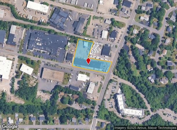
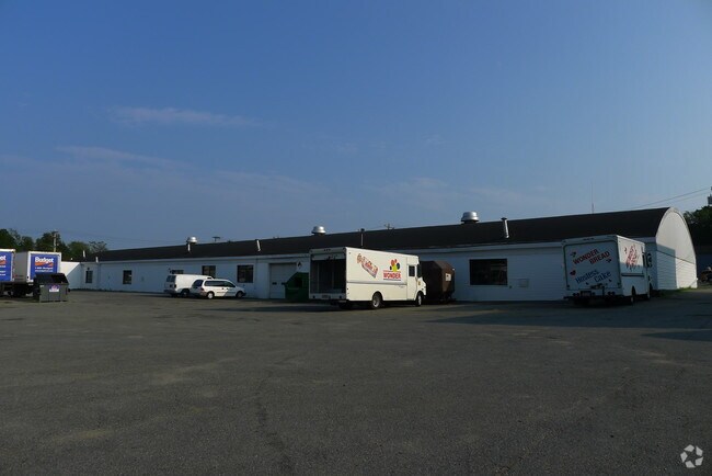
Property Record
601 Pond St, Braintree, MA 02184

NEARBY LISTINGS FOR SALE OR LEASE
Property Detail
601 Pond St
BRAI-001059-000000-000005B
Braintree
Warehouse
Norfolk
X
Massachusetts
25021C0209F
5b
2025
1.53 AC
2025
Quincy/Braintree
419800
Boston
19,780 SF
Boston-Cambridge-Newton, MA-NH
DEMOGRAPHICS near 601 Pond St
1 Mile
3 Mile
5 Mile
2024 Total Population
4,787
67,143
204,695
2029 Population
4,729
66,505
203,332
Pop Growth 2024-2029
(1.21%)
(0.95%)
(0.67%)
Average Age
43
41
41
2024 Total Households
1,733
24,897
82,174
HH Growth 2024-2029
(1.27%)
(0.94%)
(0.66%)
Median Household Inc
$108,571
$102,513
$96,949
Avg Household Size
2.70
2.60
2.40
2024 Avg HH Vehicles
2.00
2.00
2.00
Median Home Value
$488,955
$496,763
$546,228
Median Year Built
1964
1964
1962
Nearby Places
Map Layers
Map Styles
 Street
 Aerial
- Restaurants
- Banks
- Shops
- Fitness
- Groceries
PUBLIC TRANSPORTATION
COMMUTER RAIL
Braintree (Kingston/Plymouth Line - Massachusetts Bay Transportation Authority Commuter Rail (Purple Line), Middleborough/Lakeville Line - Massachusetts Bay Transportation Authority Commuter Rail (Purple Line))
DRIVE
WALK
Distance
Braintree (Kingston/Plymouth Line - Massachusetts Bay Transportation Authority Commuter Rail (Purple Line), Middleborough/Lakeville Line - Massachusetts Bay Transportation Authority Commuter Rail (Purple Line))
5 min
2.5 mi
Holbrook/Randolph (Middleborough/Lakeville Line - Massachusetts Bay Transportation Authority Commuter Rail (Purple Line))
DRIVE
WALK
Distance
Holbrook/Randolph (Middleborough/Lakeville Line - Massachusetts Bay Transportation Authority Commuter Rail (Purple Line))
6 min
3.0 mi
AIRPORT
General Edward Lawrence Logan International
DRIVE
WALK
Distance
General Edward Lawrence Logan International
26 min
15.7 mi
Freight Ports
Port of Boston
DRIVE
WALK
Distance
Port of Boston
23 min
13.5 mi
Nearby Properties
Address
Land Use
TOTAL SIZE
Lot Size
Zoning
Address
Land Use
TOTAL SIZE
Lot Size
Zoning
50.61 AC
IND
Address
Land Use
TOTAL SIZE
Lot Size
Zoning
0.25 AC
RH
Address
Land Use
TOTAL SIZE
Lot Size
Zoning
15.81 AC
Address
Land Use
TOTAL SIZE
Lot Size
Zoning
38.48 AC
B
Address
Land Use
TOTAL SIZE
Lot Size
Zoning
13.08 AC
HB
Address
Land Use
TOTAL SIZE
Lot Size
Zoning
237,086 SF
15 AC
INDB
Address
Land Use
TOTAL SIZE
Lot Size
Zoning
240,481 SF
25.23 AC
CL2
Address
Land Use
TOTAL SIZE
Lot Size
Zoning
5.38 AC
Address
Land Use
TOTAL SIZE
Lot Size
Zoning
16.08 AC
OSC
Address
Land Use
TOTAL SIZE
Lot Size
Zoning
238,217 SF
10.76 AC
INDB
Address
Land Use
TOTAL SIZE
Lot Size
Zoning
0.25 AC
I
Address
Land Use
TOTAL SIZE
Lot Size
Zoning
132,143 SF
23.70 AC
RH
Address
Land Use
TOTAL SIZE
Lot Size
Zoning
395,130 SF
6.50 AC
IND
Address
Land Use
TOTAL SIZE
Lot Size
Zoning
162,790 SF
2 AC
PUD
Address
Land Use
TOTAL SIZE
Lot Size
Zoning
18.76 AC
GBD
Address
Land Use
TOTAL SIZE
Lot Size
Zoning
167,076 SF
16 AC
A
Address
Land Use
TOTAL SIZE
Lot Size
Zoning
10.10 AC
CSBD
Address
Land Use
TOTAL SIZE
Lot Size
Zoning
38.67 AC
PUD
Address
Land Use
TOTAL SIZE
Lot Size
Zoning
80,226 SF
6.60 AC
RES
Address
Land Use
TOTAL SIZE
Lot Size
Zoning
122,808 SF
3.41 AC
Address
Land Use
TOTAL SIZE
Lot Size
Zoning
86,564 SF
8.45 AC
GBHD
Address
Land Use
TOTAL SIZE
Lot Size
Zoning
199,072 SF
10.07 AC
HB
Address
Land Use
TOTAL SIZE
Lot Size
Zoning
494,520 SF
20.80 AC
IND
Address
Land Use
TOTAL SIZE
Lot Size
Zoning
138,400 SF
55.71 AC
RM
Address
Land Use
TOTAL SIZE
Lot Size
Zoning
146,402 SF
10 AC
RES
Address
Land Use
TOTAL SIZE
Lot Size
Zoning
22.64 AC
B
Address
Land Use
TOTAL SIZE
Lot Size
Zoning
76,223 SF
19.83 AC
B
Address
Land Use
TOTAL SIZE
Lot Size
Zoning
131,359 SF
5.42 AC
INDB
Address
Land Use
TOTAL SIZE
Lot Size
Zoning
150,000 SF
11.91 AC
HBD
Address
Land Use
TOTAL SIZE
Lot Size
Zoning
114,176 SF
11.69 AC
RH
The World's #1 Commercial Real Estate Marketplace
Connect with us
© 2025 CoStar Group
The information above has been obtained from sources believed reliable. While we do not doubt its accuracy we have not verified it and make no guarantee, warranty or representation about it. It is your responsibility to independently confirm its accuracy and completeness. Any projections, opinions, assumptions, or estimates used are for example only and do not represent the current or future performance of the property. The value of this transaction to you depends on tax and other factors which should be evaluated by your tax, financial, and legal advisors. You and your advisors should conduct a careful, independent investigation of the property to determine to your satisfaction the suitability of the property for your needs.