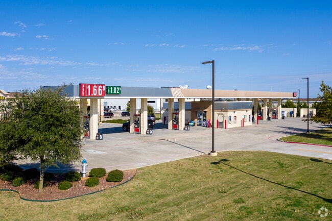
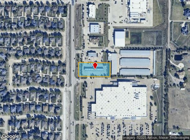
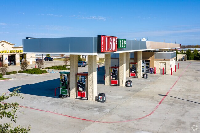
Property Record
601 S Angel Pkwy, Allen, TX 75002
NEARBY LISTINGS FOR SALE OR LEASE
Property Detail
601 S Angel Pkwy
Dallas-Fort Worth-Arlington, TX
Sc Lucas Addition (Clu)
R-10798-00A-0030-1
SC LUCAS ADDITION, BLK A, LOT 3; * REPLAT *
Commercialnec
Collin
X
Texas
48113C0100K
3
2024
1.13 AC
2025
Allen
031408
Dallas/Ft Worth
1,215 SF
DEMOGRAPHICS near 601 S Angel Pkwy
1 Mile
3 Mile
5 Mile
2024 Total Population
10,137
68,315
186,807
2029 Population
12,239
82,803
227,974
Pop Growth 2024-2029
+ 20.74%
+ 21.21%
+ 22.04%
Average Age
38
39
39
2024 Total Households
3,107
21,937
64,202
HH Growth 2024-2029
+ 20.92%
+ 21.42%
+ 22.47%
Median Household Inc
$134,677
$111,649
$110,060
Avg Household Size
3.20
3.10
2.90
2024 Avg HH Vehicles
2.00
2.00
2.00
Median Home Value
$378,701
$357,353
$401,717
Median Year Built
2002
1998
2003
Nearby Places
Map Layers
Map Styles
 Street
 Aerial
- Restaurants
- Banks
- Shops
- Fitness
- Groceries
PUBLIC TRANSPORTATION
AIRPORT
Dallas Love Field
DRIVE
WALK
Distance
Dallas Love Field
42 min
29.0 mi
Dallas-Fort Worth International
DRIVE
WALK
Distance
Dallas-Fort Worth International
47 min
36.9 mi
Nearby Properties
Address
Land Use
TOTAL SIZE
Lot Size
Zoning
Address
Land Use
TOTAL SIZE
Lot Size
Zoning
1,089,284 SF
90.69 AC
Address
Land Use
TOTAL SIZE
Lot Size
Zoning
709,804 SF
32.68 AC
Address
Land Use
TOTAL SIZE
Lot Size
Zoning
414,198 SF
72.67 AC
Address
Land Use
TOTAL SIZE
Lot Size
Zoning
382,360 SF
68.99 AC
Address
Land Use
TOTAL SIZE
Lot Size
Zoning
325,956 SF
17.33 AC
A-0
Address
Land Use
TOTAL SIZE
Lot Size
Zoning
250,510 SF
14.63 AC
PD-19
Address
Land Use
TOTAL SIZE
Lot Size
Zoning
288,865 SF
23.35 AC
Address
Land Use
TOTAL SIZE
Lot Size
Zoning
209,750 SF
10.23 AC
COMM
Address
Land Use
TOTAL SIZE
Lot Size
Zoning
185,911 SF
12.72 AC
MF-2
Address
Land Use
TOTAL SIZE
Lot Size
Zoning
164,541 SF
8.73 AC
MF 7. ACS
Address
Land Use
TOTAL SIZE
Lot Size
Zoning
122,630 SF
12.36 AC
PD
Address
Land Use
TOTAL SIZE
Lot Size
Zoning
110,005 SF
20 AC
C
Address
Land Use
TOTAL SIZE
Lot Size
Zoning
84,523 SF
9.69 AC
Address
Land Use
TOTAL SIZE
Lot Size
Zoning
93,954 SF
14.14 AC
Address
Land Use
TOTAL SIZE
Lot Size
Zoning
180,359 SF
20.92 AC
Address
Land Use
TOTAL SIZE
Lot Size
Zoning
104,241 SF
5.18 AC
PD-46
Address
Land Use
TOTAL SIZE
Lot Size
Zoning
181,968 SF
7.07 AC
CBD
Address
Land Use
TOTAL SIZE
Lot Size
Zoning
112,324 SF
12.98 AC
Address
Land Use
TOTAL SIZE
Lot Size
Zoning
74,536 SF
6.75 AC
Address
Land Use
TOTAL SIZE
Lot Size
Zoning
112,324 SF
13.77 AC
Address
Land Use
TOTAL SIZE
Lot Size
Zoning
78,414 SF
27.33 AC
Address
Land Use
TOTAL SIZE
Lot Size
Zoning
78,784 SF
6.38 AC
Address
Land Use
TOTAL SIZE
Lot Size
Zoning
87,247 SF
9.14 AC
Address
Land Use
TOTAL SIZE
Lot Size
Zoning
150,784 SF
12.08 AC
Address
Land Use
TOTAL SIZE
Lot Size
Zoning
101,781 SF
7.30 AC
MF-12
Address
Land Use
TOTAL SIZE
Lot Size
Zoning
81,024 SF
5.94 AC
MF 7. ACS
Address
Land Use
TOTAL SIZE
Lot Size
Zoning
94,004 SF
5.22 AC
SC
Address
Land Use
TOTAL SIZE
Lot Size
Zoning
80,496 SF
12 AC
Address
Land Use
TOTAL SIZE
Lot Size
Zoning
120,536 SF
6.33 AC
Address
Land Use
TOTAL SIZE
Lot Size
Zoning
89,681 SF
6.81 AC
The World's #1 Commercial Real Estate Marketplace
Connect with us
© 2026 CoStar Group
The information above has been obtained from sources believed reliable. While we do not doubt its accuracy we have not verified it and make no guarantee, warranty or representation about it. It is your responsibility to independently confirm its accuracy and completeness. Any projections, opinions, assumptions, or estimates used are for example only and do not represent the current or future performance of the property. The value of this transaction to you depends on tax and other factors which should be evaluated by your tax, financial, and legal advisors. You and your advisors should conduct a careful, independent investigation of the property to determine to your satisfaction the suitability of the property for your needs.