Property Record
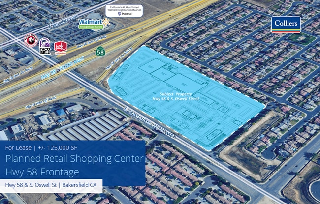
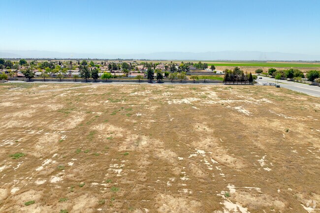
601 S Oswell St, Bakersfield, CA 93307

NEARBY LISTINGS FOR SALE OR LEASE
-
-
View all Bakersfield listings for lease on LoopNet.com
Property Detail
601 S Oswell St
Bakersfield, CA
6140 Ph 1
173-400-03-00-6
TRACT 6140 , BLOCK PH1, LOT P 62
Commercialacreage
Kern
X
California
06029C2325E
p
2024
12.58 AC
2025
Southeast Bakersfield
002403
Bakersfield
DEMOGRAPHICS near 601 S Oswell St
1 Mile
3 Mile
5 Mile
2024 Total Population
10,971
93,436
220,068
2029 Population
11,005
93,303
219,928
Pop Growth 2024-2029
+ 0.31%
(0.14%)
(0.06%)
Average Age
32
32
33
2024 Total Households
2,800
25,684
65,165
HH Growth 2024-2029
+ 0.21%
(0.19%)
(0.06%)
Median Household Inc
$50,967
$41,579
$43,836
Avg Household Size
3.90
3.50
3.30
2024 Avg HH Vehicles
2.00
2.00
2.00
Median Home Value
$241,966
$216,799
$229,082
Median Year Built
1999
1970
1970
Nearby Places
Map Layers
Map Styles
 Street
 Aerial
- Restaurants
- Banks
- Shops
- Fitness
- Groceries
PUBLIC TRANSPORTATION
COMMUTER RAIL
Bakersfield (San Joaquins - Amtrak)
DRIVE
WALK
Distance
Bakersfield (San Joaquins - Amtrak)
9 min
4.9 mi
AIRPORT
Meadows Field
DRIVE
WALK
Distance
Meadows Field
22 min
12.3 mi
Freight Ports
The Port of Hueneme
DRIVE
WALK
Distance
The Port of Hueneme
157 min
126.0 mi
SALE & LEASE HISTORY
LISTING DATE
SALE/LEASE

Jul 09, 2025
For Lease
Feb 12, 2024
For Lease
Nearby Properties
Address
Land Use
TOTAL SIZE
Lot Size
Zoning
Address
Land Use
TOTAL SIZE
Lot Size
Zoning
18,000 SF
35.01 AC
M-2
Address
Land Use
TOTAL SIZE
Lot Size
Zoning
825 SF
9.60 AC
M-3
Address
Land Use
TOTAL SIZE
Lot Size
Zoning
112,052 SF
3.14 AC
R3
Address
Land Use
TOTAL SIZE
Lot Size
Zoning
127,308 SF
8.25 AC
R-2
Address
Land Use
TOTAL SIZE
Lot Size
Zoning
161,946 SF
17.84 AC
C2 PD
Address
Land Use
TOTAL SIZE
Lot Size
Zoning
79,987 SF
3.22 AC
SP
Address
Land Use
TOTAL SIZE
Lot Size
Zoning
50,445 SF
2.53 AC
C2
Address
Land Use
TOTAL SIZE
Lot Size
Zoning
10.31 AC
Address
Land Use
TOTAL SIZE
Lot Size
Zoning
2.14 AC
C2
Address
Land Use
TOTAL SIZE
Lot Size
Zoning
17,567 SF
19.39 AC
M2
Address
Land Use
TOTAL SIZE
Lot Size
Zoning
19,350 SF
2.05 AC
Address
Land Use
TOTAL SIZE
Lot Size
Zoning
1.06 AC
R-1
Address
Land Use
TOTAL SIZE
Lot Size
Zoning
0.41 AC
R1
Address
Land Use
TOTAL SIZE
Lot Size
Zoning
74,890 SF
3.61 AC
SP
Address
Land Use
TOTAL SIZE
Lot Size
Zoning
74,890 SF
3.75 AC
SP
Address
Land Use
TOTAL SIZE
Lot Size
Zoning
68,264 SF
6.56 AC
C2
Address
Land Use
TOTAL SIZE
Lot Size
Zoning
4.94 AC
R-3
Address
Land Use
TOTAL SIZE
Lot Size
Zoning
46,522 SF
3.35 AC
R2
Address
Land Use
TOTAL SIZE
Lot Size
Zoning
22,944 SF
6.51 AC
R2
Address
Land Use
TOTAL SIZE
Lot Size
Zoning
11.05 AC
C2/PCD
Address
Land Use
TOTAL SIZE
Lot Size
Zoning
95,258 SF
5.34 AC
PUD
Address
Land Use
TOTAL SIZE
Lot Size
Zoning
171,948 SF
10.93 AC
M-3
Address
Land Use
TOTAL SIZE
Lot Size
Zoning
9,627 SF
12.37 AC
C2
Address
Land Use
TOTAL SIZE
Lot Size
Zoning
93,070 SF
7.98 AC
PUD
Address
Land Use
TOTAL SIZE
Lot Size
Zoning
97,900 SF
6.98 AC
M-2 PD
Address
Land Use
TOTAL SIZE
Lot Size
Zoning
44,779 SF
2.17 AC
M2
Address
Land Use
TOTAL SIZE
Lot Size
Zoning
Address
Land Use
TOTAL SIZE
Lot Size
Zoning
41,089 SF
5.96 AC
C-2 PD
Address
Land Use
TOTAL SIZE
Lot Size
Zoning
28,864 SF
4.78 AC
R-2
Address
Land Use
TOTAL SIZE
Lot Size
Zoning
39,175 SF
12.21 AC
M2
The World's #1 Commercial Real Estate Marketplace
Connect with us
© 2025 CoStar Group
The information above has been obtained from sources believed reliable. While we do not doubt its accuracy we have not verified it and make no guarantee, warranty or representation about it. It is your responsibility to independently confirm its accuracy and completeness. Any projections, opinions, assumptions, or estimates used are for example only and do not represent the current or future performance of the property. The value of this transaction to you depends on tax and other factors which should be evaluated by your tax, financial, and legal advisors. You and your advisors should conduct a careful, independent investigation of the property to determine to your satisfaction the suitability of the property for your needs.