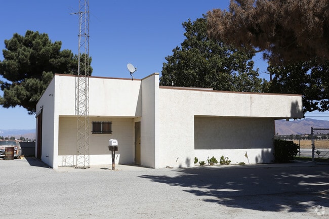
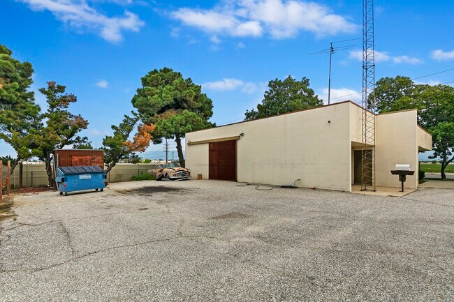
Property Record
601 S Sanderson Ave, Hemet, CA 92545

NEARBY LISTINGS FOR SALE OR LEASE
Property Detail
601 S Sanderson Ave
Riverside-San Bernardino-Ontario, CA
Parcel Map 27724
456-030-045
ACRES 2.00000000 ACREAGEQUALCODE ML LOTTYPE P PARCEL 1, 2 MAPPLATB 185 MAPPLATP 087 SUBDIVISIONNAME PM 27724
Storebuilding
Riverside
X
California
06065C2085G
1
2024
2 AC
2025
Beaumont/Hemet
043519
Inland Empire (California)
11,837 SF
DEMOGRAPHICS near 601 S Sanderson Ave
1 mile
3 mile
5 mile
2024 Total Population
12,460
85,594
163,907
2029 Population
13,082
90,791
173,301
Pop Growth 2024-2029
+ 4.99%
+ 6.07%
+ 5.73%
Average Age
44
40
38
2024 Total Households
4,837
30,547
53,126
HH Growth 2024-2029
+ 4.65%
+ 5.70%
+ 5.42%
Median Household Inc
$49,619
$48,644
$54,580
Avg Household Size
2.50
2.70
2.90
2024 Avg HH Vehicles
2.00
2.00
2.00
Median Home Value
$203,193
$232,670
$293,696
Median Year Built
1985
1983
1984
Nearby Places
Map Layers
Map Styles
 Street
 Aerial
Transit
 Traffic
 Biking
Places
Listings with unknown addresses are not visible on the map
- Restaurants
- Banks
- Shops
- Fitness
- Groceries
PUBLIC TRANSPORTATION
AIRPORT
Palm Springs International
Drive
Walk
Distance
Palm Springs International
55 min
45.9 mi
Ontario International
Drive
Walk
Distance
Ontario International
64 min
49.5 mi
SALE & LEASE HISTORY
LISTING DATE
SALE/LEASE

Sep 25, 2016
For Lease
Oct 05, 2017
For Sale
Apr 24, 2020
For Sale
Nearby Properties
Address
Land Use
TOTAL SIZE
Lot Size
Zoning
Address
Land Use
TOTAL SIZE
Lot Size
Zoning
850,640 SF
42.40 AC
Address
Land Use
TOTAL SIZE
Lot Size
Zoning
19,856 SF
128.14 AC
C1
Address
Land Use
TOTAL SIZE
Lot Size
Zoning
168,761 SF
20.67 AC
Address
Land Use
TOTAL SIZE
Lot Size
Zoning
4,550 SF
127.73 AC
Address
Land Use
TOTAL SIZE
Lot Size
Zoning
306,540 SF
7.69 AC
Address
Land Use
TOTAL SIZE
Lot Size
Zoning
5.96 AC
Address
Land Use
TOTAL SIZE
Lot Size
Zoning
94,476 SF
4.86 AC
R3
Address
Land Use
TOTAL SIZE
Lot Size
Zoning
63,960 SF
8.57 AC
R3
Address
Land Use
TOTAL SIZE
Lot Size
Zoning
21,120 SF
45.06 AC
MIX
Address
Land Use
TOTAL SIZE
Lot Size
Zoning
165,401 SF
13.45 AC
C1
Address
Land Use
TOTAL SIZE
Lot Size
Zoning
459,613 SF
18.24 AC
Address
Land Use
TOTAL SIZE
Lot Size
Zoning
9,184 SF
4.75 AC
R3
Address
Land Use
TOTAL SIZE
Lot Size
Zoning
50,160 SF
5.93 AC
R3
Address
Land Use
TOTAL SIZE
Lot Size
Zoning
27,964 SF
5.47 AC
Address
Land Use
TOTAL SIZE
Lot Size
Zoning
53,140 SF
6.74 AC
C2
Address
Land Use
TOTAL SIZE
Lot Size
Zoning
89,317 SF
5.77 AC
Address
Land Use
TOTAL SIZE
Lot Size
Zoning
40,880 SF
6 AC
R3
Address
Land Use
TOTAL SIZE
Lot Size
Zoning
66,482 SF
9.11 AC
A1
Address
Land Use
TOTAL SIZE
Lot Size
Zoning
167,396 SF
9.36 AC
Address
Land Use
TOTAL SIZE
Lot Size
Zoning
23.04 AC
Address
Land Use
TOTAL SIZE
Lot Size
Zoning
44,600 SF
6.41 AC
Address
Land Use
TOTAL SIZE
Lot Size
Zoning
1,488 SF
36.75 AC
Address
Land Use
TOTAL SIZE
Lot Size
Zoning
59,680 SF
5.80 AC
C2
Address
Land Use
TOTAL SIZE
Lot Size
Zoning
42,064 SF
4.71 AC
C1
Address
Land Use
TOTAL SIZE
Lot Size
Zoning
69,306 SF
6.02 AC
Address
Land Use
TOTAL SIZE
Lot Size
Zoning
101,172 SF
7.48 AC
Address
Land Use
TOTAL SIZE
Lot Size
Zoning
58,941 SF
9.06 AC
M1
Address
Land Use
TOTAL SIZE
Lot Size
Zoning
79,683 SF
7.97 AC
C1
Address
Land Use
TOTAL SIZE
Lot Size
Zoning
58,941 SF
7.14 AC
The World's #1 Commercial Real Estate Marketplace
Connect with us
© 2026 CoStar Group
The information above has been obtained from sources believed reliable. While we do not doubt its accuracy we have not verified it and make no guarantee, warranty or representation about it. It is your responsibility to independently confirm its accuracy and completeness. Any projections, opinions, assumptions, or estimates used are for example only and do not represent the current or future performance of the property. The value of this transaction to you depends on tax and other factors which should be evaluated by your tax, financial, and legal advisors. You and your advisors should conduct a careful, independent investigation of the property to determine to your satisfaction the suitability of the property for your needs.