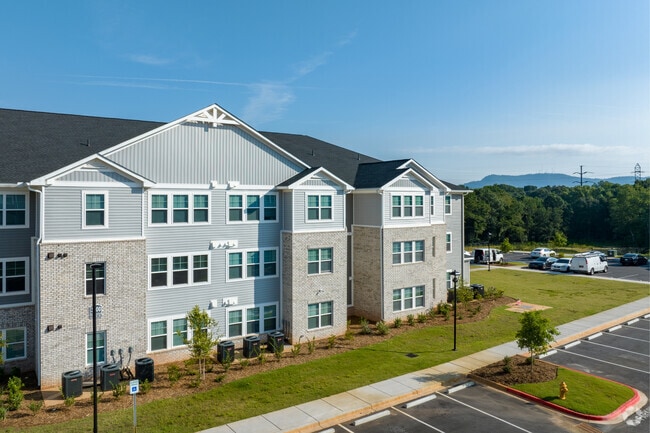
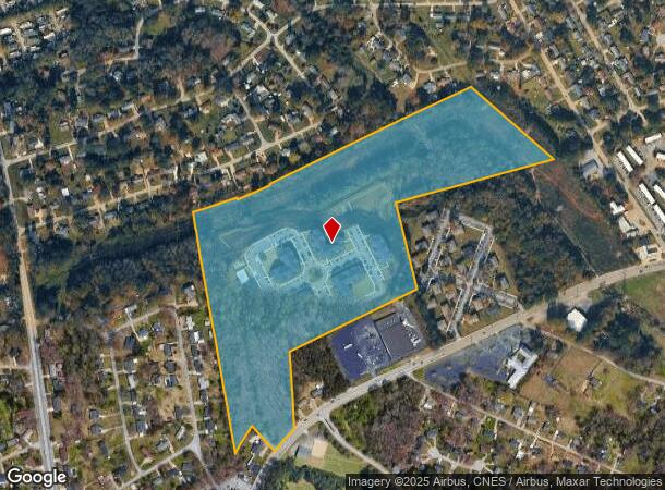
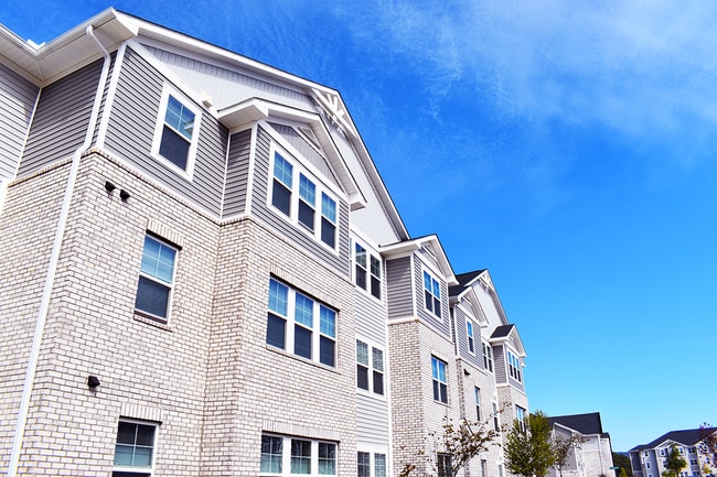
Property Record
6010 Jacks Lookout Rd, Greenville, SC 29617
NEARBY LISTINGS FOR SALE OR LEASE
Property Detail
6010 Jacks Lookout Rd
Greenville-Anderson-Mauldin, SC
Western Hills
B008.02-01-015.00
MAP B008.02
Apartment
Greenville
AE
South Carolina
45045C0314E
015.00
2025
39.90 AC
2024
Berea
003707
Greenville/Spartanburg
DEMOGRAPHICS near 6010 Jacks Lookout Rd
1 Mile
3 Mile
5 Mile
2024 Total Population
7,306
50,697
113,255
2029 Population
8,071
55,986
125,760
Pop Growth 2024-2029
+ 10.47%
+ 10.43%
+ 11.04%
Average Age
40
38
39
2024 Total Households
2,858
19,612
46,100
HH Growth 2024-2029
+ 10.71%
+ 10.68%
+ 11.39%
Median Household Inc
$44,182
$44,700
$49,636
Avg Household Size
2.40
2.40
2.30
2024 Avg HH Vehicles
2.00
2.00
2.00
Median Home Value
$158,321
$166,172
$218,475
Median Year Built
1981
1980
1984
Nearby Places
Map Layers
Map Styles
 Street
 Aerial
- Restaurants
- Banks
- Shops
- Fitness
- Groceries
PUBLIC TRANSPORTATION
COMMUTER RAIL
Greenville Amtrak Station (Crescent - Amtrak)
DRIVE
WALK
Distance
Greenville Amtrak Station (Crescent - Amtrak)
9 min
4.2 mi
AIRPORT
Greenville Spartanburg International
DRIVE
WALK
Distance
Greenville Spartanburg International
32 min
18.8 mi
Freight Ports
North Charleston Terminal
DRIVE
WALK
Distance
North Charleston Terminal
239 min
209.4 mi
Nearby Properties
Address
Land Use
TOTAL SIZE
Lot Size
Zoning
Address
Land Use
TOTAL SIZE
Lot Size
Zoning
22.97 AC
R12
Address
Land Use
TOTAL SIZE
Lot Size
Zoning
22.58 AC
RRROW
Address
Land Use
TOTAL SIZE
Lot Size
Zoning
14.41 AC
R15
Address
Land Use
TOTAL SIZE
Lot Size
Zoning
703.30 AC
RS
Address
Land Use
TOTAL SIZE
Lot Size
Zoning
20.04 AC
RM
Address
Land Use
TOTAL SIZE
Lot Size
Zoning
10.10 AC
RM
Address
Land Use
TOTAL SIZE
Lot Size
Zoning
10.17 AC
RM
Address
Land Use
TOTAL SIZE
Lot Size
Zoning
2.14 AC
RM
Address
Land Use
TOTAL SIZE
Lot Size
Zoning
2.21 AC
RMA
Address
Land Use
TOTAL SIZE
Lot Size
Zoning
Address
Land Use
TOTAL SIZE
Lot Size
Zoning
8.29 AC
I1
Address
Land Use
TOTAL SIZE
Lot Size
Zoning
4.97 AC
RM20
Address
Land Use
TOTAL SIZE
Lot Size
Zoning
32.18 AC
C2
Address
Land Use
TOTAL SIZE
Lot Size
Zoning
15.60 AC
I1
Address
Land Use
TOTAL SIZE
Lot Size
Zoning
30.52 AC
C2
Address
Land Use
TOTAL SIZE
Lot Size
Zoning
22.92 AC
R10
Address
Land Use
TOTAL SIZE
Lot Size
Zoning
8.40 AC
I1
Address
Land Use
TOTAL SIZE
Lot Size
Zoning
1.83 AC
RM
Address
Land Use
TOTAL SIZE
Lot Size
Zoning
165.20 AC
RS
Address
Land Use
TOTAL SIZE
Lot Size
Zoning
18.22 AC
RM
Address
Land Use
TOTAL SIZE
Lot Size
Zoning
16.81 AC
I1
Address
Land Use
TOTAL SIZE
Lot Size
Zoning
19.79 AC
S1
Address
Land Use
TOTAL SIZE
Lot Size
Zoning
14.46 AC
RM
Address
Land Use
TOTAL SIZE
Lot Size
Zoning
22.88 AC
C2
Address
Land Use
TOTAL SIZE
Lot Size
Zoning
5.05 AC
C2
Address
Land Use
TOTAL SIZE
Lot Size
Zoning
1.43 AC
C1N
Address
Land Use
TOTAL SIZE
Lot Size
Zoning
153.11 AC
R10
Address
Land Use
TOTAL SIZE
Lot Size
Zoning
1,410 SF
10.17 AC
R10
Address
Land Use
TOTAL SIZE
Lot Size
Zoning
15.82 AC
Address
Land Use
TOTAL SIZE
Lot Size
Zoning
100 AC
RS
The World's #1 Commercial Real Estate Marketplace
Connect with us
© 2026 CoStar Group
The information above has been obtained from sources believed reliable. While we do not doubt its accuracy we have not verified it and make no guarantee, warranty or representation about it. It is your responsibility to independently confirm its accuracy and completeness. Any projections, opinions, assumptions, or estimates used are for example only and do not represent the current or future performance of the property. The value of this transaction to you depends on tax and other factors which should be evaluated by your tax, financial, and legal advisors. You and your advisors should conduct a careful, independent investigation of the property to determine to your satisfaction the suitability of the property for your needs.